- All Categories (23920)
- Data (34)
- News (97)
- Missions (2)
- Events (31)
- Tools (9)
- Activities (6)
- Campaigns (19)
- Documents (23722)
NEWS
Discover the latest news on the European Space Agency's Earth Observation activities. Learn all about new data availability and how ESA's missions are performing.
News - Data Release news
 7 Feb 2020
2011 CryoSat Ice Baseline D reprocessed data available
We are pleased to inform the CryoSat scientific community that the reprocessed CryoSat Ice Baseline D data for all of 2011 has been published on the Science Server and is available for download.
News - Data Release news
 21 Feb 2020
2012 CryoSat Ice Baseline D reprocessed data now available
We're pleased to inform the CryoSat scientific community that the reprocessed CryoSat Ice Baseline D data for all of 2012 has been published on the Science Server and is now available for download.
News - Data Release news
 12 Mar 2020
2013 CryoSat Ice Baseline D reprocessed data available
We are pleased to inform the CryoSat scientific community that the reprocessed CryoSat Ice Baseline D data for all of 2013 has been published on the Science Server and is now available for download.
News - Data Release news
 2 Apr 2020
2014 CryoSat Ice Baseline D reprocessed data available
Reprocessed CryoSat Ice Baseline D data for all 2014 has been published on the Science Server and is available for download.
News - Data Release news
13 May 20202015 CryoSat Ice Baseline D reprocessed data now available
The reprocessed CryoSat Ice Baseline D data for all of 2015 has now been published on the Science Server.
News - Data Release news
 15 May 2020
2016 CryoSat Ice Baseline D reprocessed data now available
The reprocessed CryoSat Ice Baseline D data for 2016 has now been published on the Science Server.
News - Data Release news
12 June 20202017 CryoSat Ice Baseline D reprocessed data available
The reprocessed CryoSat Ice Baseline D data for all of 2017 is now available for download.
News - Infographics
12 Jan 2023About cs2eo.org – Accessing combined ESA and NASA altimetry data
cs2eo.org is a free, easy-to-use portal that make it easier and quicker than ever to work with combined CryoSat and ICESat altimetry data.
News - Operational News
 15 Feb 2024
Announcement for CryoSat Quaternions Product users
CryoSat users who use the Quaternions Products should be aware that the method to access these products is changing.
News - Data Release news
 14 Apr 2023
Back-processed data from 2010 now available for CryoTEMPO-EOLIS Baseline 2
Following on from the release of new Baseline 2 point and gridded products for CryoTEMPO-EOLIS, the data for several regions have now been back-processed to 2010 and are available from the CryoSat Science Server.
News - Data Release news
28 Mar 2023Brand new Cryo-TEMPO Baseline-B boosts CryoSat research
New datasets have been released for the Cryo-TEMPO thematic products.
News - Data Release news
 9 July 2020
Complete CryoSat Ice Baseline D reprocessed dataset now available
We're pleased to inform the CryoSat scientific community that the full reprocessed CryoSat Ice Baseline D data are now available on the Science Server for download
News - Success Stories
 25 Nov 2021
COP26 fuels interest in satellite data
As COP26 stimulates action to reduce global warming, the essential role of satellite data in understanding and monitoring climate change is apparent.
News - Data Release news
30 Apr 2024Cryo-TEMPO gets new Summer Sea Ice product
CryoSat’s remarkable 14-year record of global ice and sea levels got another upgrade with the release of Cryo-TEMPO baseline C, which includes lots of new features and improvements.
News - General News
 10 July 2020
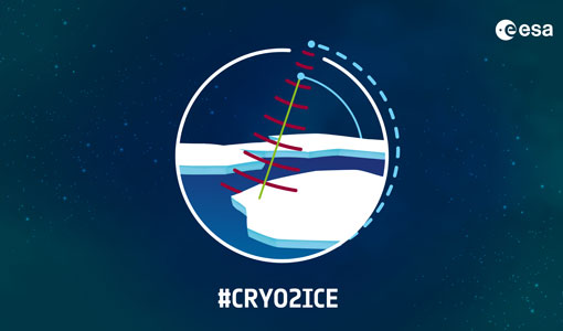
CRYO2ICE is now on Earth Online
On 16 July, ESA is kicking off the CRYO2ICE campaign that will raise the orbit of its CryoSat-2 satellite to periodically align with NASA’s ICESat-2.
News - Operational News
12 Aug 2020CRYO2ICE Orbit Raising Campaign: Data Quality Status
During the CRYO2ICE Orbit Raising Campaign, the CryoSat QC team monitored data production between the orbit manoeuvres and performed detailed checks of all Near Real Time (NRT) data generated.
News - Success Stories
 12 July 2022
CRYO2ICE over Antarctica: revealing further insight on changing ice
The CryoSat-2 satellite is currently being aligned with ICESat-2 over Antarctica, unlocking fresh possibilities in the wealth of new information being delivered by the near-synchronous orbit of the two satellites.
News - Infographics
 27 Oct 2020
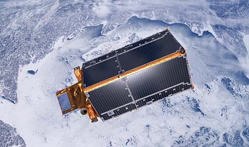
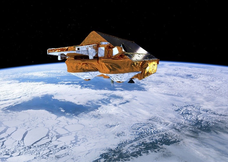
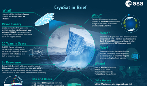
CryoSat - ESA’s cryosphere satellite mission
CryoSat - ESA's ice mission - recently celebrated ten years in space, during which it has provided invaluable data for research. To mark the anniversary we put together an infographic about the mission and its many achievements.
News - Maintenance News
 21 Feb 2024
CryoSat CalVal server downtime on 27 February 2024
Due to routine maintenance activities on 27 February 2024, between 08:00-10:00 UTC, the distribution of CryoSat L0 products and AUX files may be impacted.
News - General News
27 Apr 2023CryoSat data users - We need your feedback!
The CryoSat Quality Control (QC) team are looking for CryoSat data users to complete a quick survey about data QC.