- All Categories (24)
- Data (2)
- News (6)
- Events (9)
- Tools (1)
- Campaigns (1)
- Documents (5)
NEWS
Discover the latest news on the European Space Agency's Earth Observation activities. Learn all about new data availability and how ESA's missions are performing.
News - Thematic area articles
3 Mar 2023Monitoring water on Earth's surface
ESA's Earth observation satellites are playing a leading role in furthering our understanding of how Earth's terrestrial hydrosphere is being influenced by humankind.
News - Thematic area articles
9 Dec 2022Global understanding of Earth's land surfaces greatly boosted by satellite data
ESA perform land surface monitoring with a range of instruments onboard satellites acquiring optical and radar data. Collections of data from these missions are freely available for research purposes.
News - Thematic area articles
 2 Feb 2022
Satellite data boost global understanding of land surface
Understanding our changing land surface is essential in the study of climate change. Satellites are used to monitor changes to the material that covers Earth’s surface, so-called land cover, such as vegetation and water.
News - Infographics
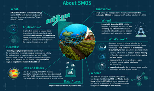 30 Mar 2021
SMOS - ESA's soil moisture and ocean salinity mission
Learn more about the Soil Moisture and Ocean Salinity (SMOS) mission in our latest infographic.
News - General News
22 Dec 2020Introducing the Newest ESA Third Party Missions
ESA's Earth Observation Programme Board has unanimously approved the integration of the Federated Satellite Systems (FSSCat) mission, the Geostationary Environment Monitoring Spectrometer (GEMS) instrument on-board the GEO-KOMPSAT-2B satellite and the Gravity Recovery and Climate Experiment Follow-On (GRACE-FO) mission, as Third Party Missions.
News - Success Stories
 22 Dec 2020
Using Satellite Data to Predict Floods and Droughts
Scientists are turning to remote sensing to fill the in-situ data gap in hydrological data models in some parts of the world.