- All Categories (23532)
- Data (27)
- News (108)
- Missions (2)
- Events (10)
- Tools (14)
- Activities (4)
- Campaigns (6)
- Documents (23361)
News - Data Release news
Cryo-TEMPO gets new Summer Sea Ice product
CryoSat’s remarkable 14-year record of global ice and sea levels got another upgrade with the release of Cryo-TEMPO baseline C, which includes lots of new features and improvements.
Document - Newsletter
Earth Online Newsletter - 19 April 2024
This issue of the Earth Online Newsletter covers a selection of the latest news and events from ESA.
News - Data Release news
New Ocean data and more boost CryoSat data platform
Eight new datasets have been added to the CS2EO platform to support, enhance, and simplify research using CryoSat data. They include the CryoSat Ocean Product, and the Cryo-TEMPO Land Ice, Sea Ice, Polar Ocean, Coastal Ocean and Inland Water datasets.
News - How to guides
HEDAVI Discover: a step-by-step guide
The Heritage Data Visualisation tool (HEDAVI) is a platform developed by the French Science Consulting for Earth Observation group, VisioTerra, which allows users to freely access over 40 years of ESA Earth Observation Heritage data, Third Party Missions and some Copernicus data.
Tools - Catalogues
CS2EO
CS2EO is a data catalogue that allows users to easily and quickly combine and download airborne and spaceborne altimetry data from CryoSat-2, ICESat-2, CryoVEx, IceBridge and CryoTEMPO-EOLIS.
Data - Sample Data (Open)
CryoSat Data Samples
Download CryoSat data samples from Baseline-B, C, and D products.
News - Data Release news
CryoSat swath data boosted with new glacier regions and gridded products
Additional products have been added to CryoTEMPO-EOLIS Baseline 2, increasing global coverage and adding to the range of available gridded data.
News - Maintenance News
CryoSat CalVal server downtime on 27 February 2024
Due to routine maintenance activities on 27 February 2024, between 08:00-10:00 UTC, the distribution of CryoSat L0 products and AUX files may be impacted.
News - Operational News
Announcement for CryoSat Quaternions Product users
CryoSat users who use the Quaternions Products should be aware that the method to access these products is changing.
News - Operational News
Delay in the availability of CryoSat Products
A technical issue occurred at the CryoSat Payload Data Ground Segment (PDGS).
News - Success Stories
CryoSat land ice data track destabilisation of Antarctic glacier
Even apparently stable glaciers in Antarctica are at risk of losing large quantities of ice due to warming seas. The warning comes after satellite data showed the Cadman glacier – previously stable for 50 years - retreated by 8 km between November 2018 and May 2021.
News - Success Stories
Discover Earth like never before: the HEDAVI tool
The Heritage Data Visualisation tool, or HEDAVI, enables the analysis of global spatio-temporal dynamics of natural and artificial environments, covering over 40 years of ESA Earth Observation Heritage data, Third Party Missions and some Copernicus data.
News - Success Stories
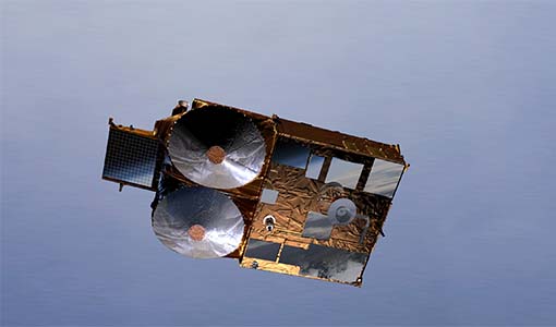
CryoSat safe and sound
A fuel leak aboard the CryoSat satellite threatened to bring the mission to an end in 2025 however operators at ESOC initiated a swap to a back-up system thus saving the satellite for years to come.
Data - Fast Registration with approval (Restrained)
ALOS PRISM L1C
This collection provides access to the ALOS-1 PRISM (Panchromatic Remote-sensing Instrument for Stereo Mapping) OB1 L1C data acquired by ESA stations (Kiruna, Maspalomas, Matera, Tromsoe) in the ADEN zone, in addition to worldwide data requested by European scientists. The ADEN zone was the area belonging to the European Data node and covered both the European and African continents, a large part of Greenland and the Middle East. The full mission archive is included in this collection, though with gaps in spatial coverage outside of the ADEN zone. With respect to the L1B collection, only scenes acquired in sensor mode with a Cloud Coverage score lower than 70% and a sea percentage lower than 80% are published: Orbits: from 2768 to 27604 Path (corresponds to JAXA track number): from 1 to 665 Row (corresponds to JAXA scene centre frame number): from 310 to 6790. The L1C processing strongly improve accuracy compared to L1B1 from several tenths of metres in L1B1 (~40 m of northing geolocation error for Forward views and ~10-20 m for easting errors) to some metres in L1C scenes (< 10 m both in north and easting errors). The collection contains only the PSM_OB1_1C EO-SIP product type, using data from PRISM operating in OB1 mode with three views (Nadir, Forward, and Backward) at 35 km wide. Most of the products contain all three views, but the Nadir view is always available and is used for the frame number identification. All views are packaged together; each view, in CEOS format, is stored in a directory named according to the JAXA view ID naming convention.
News - Data Release news
Global glacier mass change data now available from CryoSat
Measuring glacier mass changes from space is more accurate and comprehensive thanks to the CryoTEMPO-EOLIS CryoSat swath data products, which now cover glaciers worldwide.
News - Data Release news
CryoSat Ice Baseline-E Reprocessed Data - Update
Previously, quality checks of the Ice Baseline-E reprocessing products observed a discrepancy in the metadata of products with incremented version numbers (E002, E003).
News - Thematic area articles
Cloud-free collections key for land monitoring
Satellite imagery is a crucially important tool for monitoring the land, but cloud cover can often block parts of Earth’s surface from view, limiting subsequent analyses.
News - Success Stories
New CryoSat data to boost understanding of the oceans
A new CryoSat sea level anomaly product designed to enable ocean science and the development of operational marine applications has been released.
News - Data Release news
ALOS PRISM L1C European Coverage Cloud Free data collection now available for users
As part of Earthnet’s Third Party Missions Programme framework, ESA is pleased to announce that the ALOS PRISM L1C European Coverage Cloud Free data collection is now available for research purposes.
Data - Fast Registration with approval (Restrained)
ALOS PRISM L1C European Coverage Cloud Free
This collection is composed of a subset of ALOS-1 PRISM (Panchromatic Remote-sensing Instrument for Stereo Mapping) OB1 L1C products from the ALOS PRISM L1C collection (DOI: 10.57780/AL1-ff3877f) which have been chosen so as to provide a cloud-free coverage over Europe. 70% of the scenes contained within the collection have a cloud cover percentage of 0%, while the remaining 30% of the scenes have a cloud cover percentage of no more than 20%. The collection is composed of PSM_OB1_1C EO-SIP products, with the PRISM sensor operating in OB1 mode with three views (Nadir, Forward and Backward) at 35 km width.


