- All Categories (1432)
- Data (7)
- News (11)
- Missions (12)
- Events (9)
- Tools (5)
- Activities (8)
- Campaigns (2)
- Documents (1378)
Event - Workshop
Workshop on International Cooperation in Spaceborne Imaging Spectroscopy
The workshop aimed to recommend future international coordination permitting cooperation in the deployment, operation, and exploitation of space-based imaging spectrometers for terrestrial and coastal scientific and operational applications.
Document - Product Cal/Val Plan/Report
Validation Report following the 3rd MERIS data reprocessing
This document prepared by the MERIS Quality Working Group (QWG) corresponds to the Validation Report following the 3rd MERIS data reprocessing. It aims at qualifying and quantifying the accuracy of the MERIS L2 products generated with the version 8.0 of MERIS Ground Segment prototype (MEGS), delivered to the whole community through the ODESA software (http://earth.eo.esa.int/odesa/). It is equivalent to version 6.0 of the Instrument Processing Facilities (IPF) at ESRIN.
Document - Product Cal/Val Plan/Report
VALID Annual Report 2008
Validation of GOMOS version ozone profiles using ground-based lidar observations
Event - Workshop
URBIS24
URBan Insights from Space (URBIS24) Workshop will offer an insightful exploration of urban challenges and innovative EO-integrated solutions.
News - General News
Updated SMOS documentation available
Updated versions of several SMOS data documents are now available.
Document - Proceedings
Topographic mapping from small satellites- a case study of CHRIS-PROBA data
This paper presents a study on the use of various empirical models for satellite orientation and terrain modelling using multidirectional CHRIS data, and evaluates the potential of small satellites with multidirectional viewing capabilities for topographic mapping.
Document - Technical Note
The Status of the SCIAMACHY Active Thermal Control (ATC)
The Active Thermal Control System (ATC) is providing thermal stability to SCIAMACHY's optical bench module (OBM). Over the past 10 years in-orbit mission lifetime the ATC has proven extremely reliable. Although regular monitoring has revealed some degradation ??? less than what was predicted before launch ??? only a single adjustment was necessary so far to keep the OBM temperature within the specified limit. The ATC adjustment occurred in October 2008 in orbit 34643 [RD1 with referencing RD3-RD6].
Document - General Reference
The Soil Moisture and Ocean Salinity Mission - SMOS
This document outlines the SMOS mission objectives and the derived scientific mission requirements.
Document - Technical Note
The RA-2 On-Board Tracker and its Autonomous Adaptable Resolution
This technical note describes the complete functionality of the RA-2 on-board Tracker and how its Resolution Selection Logic (RSL) works. It gives a detailed analysis of the algorithm and its configuration parameters.
Document - Product Cal/Val Plan/Report
TASTE-final-report-October-2008-October-2011.pdf
The present document is the final report of the three-year Multi-TASTE project (October 2008-October 2011). Multi-TASTE has provided ESA with MULTI-mission Technical ASsistance To the validation of atmospheric composition data acquired by Envisat and Third Party Missions (TPM).
Document - General Reference
Star-in-the-sky-The-SMOS-payload-MIRAS.pdf
This is an article extracted from the ESA Bulletin Nr.137.
News - Success Stories
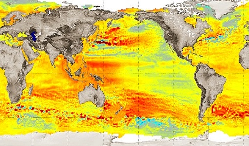
Spotlight on sea-level rise
Scientists to share findings on how satellite has revealed changes in the height of the sea, ice, inland bodies of water and more.
Document - General Reference
SMOS-over-land-New-applications-for-ESAs-water-mission.pdf
This is an article extracted from the ESA Bulletin Nr. 152.
Document - Technical Note
SMOS-Mission-Objectives-and-Scientific-Requirements.pdf
This document outlines the SMOS mission objectives and the derived scientific mission requirements.
Document - Technical Note
SMOS-L1B-Data-Processing-Model-Document
The main purpose of this document is to provide a detailed definition of the processes and algorithms contained in the Foreign Sources Correction and Image Reconstruction modules for SMOS Level-1B products.
Document - General Reference
SMOS-ESAs-Water-Mission.pdf
This brochure describes the science behind the SMOS mission and how the satellite works.

