- News
- SMOS data improve estimates of...
SMOS data improve estimates of rainfall in Africa
03 Nov 2022
Scientists have used soil moisture data from ESA’s SMOS mission to correct high-resolution satellite-based estimates of precipitation in Africa.
The improved product – which is made available in near-real time – has the potential to support numerous applications, including flood forecasting, water resources management, and crop yield predictions.
Earth observation missions have been helping to estimate rainfall for decades.
Using the visible, infrared or microwave radiation, satellite instruments measure the amount of energy that is emitted or reflected from clouds and raindrops in the atmosphere.
Today scientists use information from microwave and infrared sensors to inform datasets that detail different kinds of precipitation across the globe.
These include a unified satellite precipitation product produced by NASA called IMERG, which was the focus of the project.
Satellite-based datasets are generally able to show where and when it rains but their estimates of the amount of precipitation are subject to biases. To correct for this, scientists use measurements from ground-based rain gauge networks.
As a result, products such as IMERG are typically available in two forms.
First, a real-time product is released that relies only on the remote sensing observations or the model outputs. Following this, an adjusted version is then made available that incorporates the ground observations.
Retrieving and assimilating in-situ rain data is a lengthy process, so there is often a delay of between one and three months before the corrected product is published.
In addition, the networks of precipitation gauges in some parts of Africa are sparse, resulting in large gaps in ground-based rainfall data.
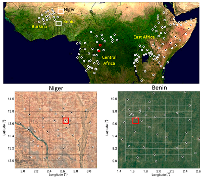
To address these challenges, scientists completed a project in which data from SMOS was used as an alternative to rain gauge measurements. It covered the whole of Africa, with a focus for assessment on the western, central and eastern regions of the continent.
Launched in 2009, SMOS forms part of ESA’s Earth Explorers programme. It uses a microwave L-band sensor to measure soil moisture across the globe at a resolution of between 35 and 50 km.
As part of the study, scientists assimilated these data into IMERG, which has a spatial resolution of around 11 km.
A key aim of the project was to determine whether relatively coarse soil moisture data could be used to improve the higher resolution rainfall product.
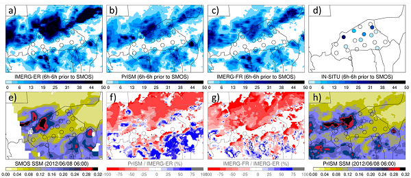
During the study, a methodology called PrISM was employed. This consists of simulating soil moisture using the IMERG product and then modifying its precipitation rate to reduce the discrepancy between the simulated data and the soil moisture observed by SMOS. This process results in a correction of the IMERG estimates in near real time.
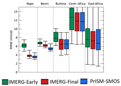
Data from the network of rain gauges was then used to determine the success of this assimilation.
It was found that the use of SMOS data almost systematically improved the IMERG estimates. In addition, the quality of the PrISM precipitation product tended towards – and sometimes outperformed – those of the debiased IMERG product that was adjusted using rain gauge data.
As a result, SMOS soil moisture measurements in Africa were reported to be a more reliable and faster alternative to rain gauge measurements for debiasing satellite-based precipitation estimates in real time.
Thierry Pellarin, research scientist at the French National Centre for Scientific Research and lead author of the study, said, “It has long been known that soil moisture measurements have great potential to correct the biases of satellite-based rainfall products. Currently, however, only two precipitation products use this information.
“Here we have shown that data from SMOS can both improve the estimations of a high-resolution rainfall product in Africa and accelerate the production of these data. This could benefit citizens by facilitating numerous important operational applications.”
References:
Citation: Pellarin, T.; Zoppis, A.;Román-Cascón, C.; Kerr, Y.H.; Rodriguez-Fernandez, N.; Panthou, G.; Philippon, N.; Cohard, J.-M. From SMOS Soil Moisture to 3-hour Precipitation Estimates at 0.1° 2022, 14, 746. https://doi.org/10.3390/rs14030746
Data available :
https://zenodo.org/record/5998113#.Y1k1BITP02w (0.1° product)
https://zenodo.org/record/4769825#.Y1k1GYTP02w (0.25° product)