- News
- Forty years of heritage data h...
Forty years of heritage data highlight warming European lakes
19 May 2020
In the last decade, climate change has taken centre stage in both the public and scientific arenas, as increasingly extreme weather and human impact on the environment have become more apparent. Debates and calls to action have fuelled interest in long-term science and environmental monitoring applications, with satellite data and remote sensing emerging as key contributors to this new wave of climatological research.
Documenting human-made changes from space and monitoring global conditions that are particularly relevant for climatological studies, remote sensing combines ground measurements and climate model results with Essential Climate Variables (ECVs) as defined by the Global Climate Observing System (GCOS) and tracked through satellite data.
However, the World Meteorological Organisation (WMO) reported that at least 30 years of data are necessary to detect statistically significant changes of ECVs.
As early as 2008, ESA recognised the importance of long time-series of datasets in determining changes in the planet's climate and launched the Long Term Data Preservation (LTDP) programme, to preserve these valuable data for future generations. The programme’s aim was to ensure that older data would continue to be accessible and usable after many years. The LTDP was extended in 2016 under a new name: the Heritage Space Programme.
In the frame of ESA's Heritage Space Programme, a new project has now consolidated and harmonised existing Advanced Very High Resolution Radiometer (AVHRR) data acquired over Europe, creating a continuous time series for essential climate variables that stretches nearly 40 years, from 1981 to 2019.
The AVHRR instrument was first carried onboard NOAA satellites starting in 1981 and later added from 2006 onwards to MetOp satellites operated by EUMETSAT. The Remote Sensing Research Group (RSGB) and the Oeschger Centre for Climate Change Research at the University of Bern, in Switzerland, have specialised in the development of algorithms and procedures to retrieve ECVs from AVHRR data, generating time series covering Europe starting from 1989.
The variables included Aerosol, Snow Cover Extent, Clouds, Albedo, Lake Ice, Active Fires and Lake Surface Water Temperature. Access to the RSGB archive, however, has been limited for external scientists. With data starting only from 1989, the RSGB archive was also missing an essential dataset of high climatological interest: the 1980s.
ESA and the University of Bern have now pooled their AVHRR data together to create a valuable data set accessible free of charge to all interested users. And thanks to an agreement struck between the University of Dundee in the UK and ESA, the gaps in data from 1981 until 1989 have been filled with data acquired by the Dundee Satellite Receiving Station. The final data set, covering Europe from 1981 to 2019, has been consolidated through a dedicated project funded by ESA and is now freely accessible through ESA’s Online Access Dissemination Service.
“Climate change is one of the big challenges being faced by humankind today,” says Mirko Albani, ESA’s Heritage Space Programme Manager. “The availability of long time series of coherent and harmonised data from space, like the AVHRR data set just generated in the frame of the Heritage Space Programme, is crucial to properly monitor, understand and react to the changes affecting our planet and our daily lives."
The high relevance of the consolidated AVHRR data set was shown in a recent scientific publication, in the Remote Sensing Journal by Gian Lieberherr and Stefan Wunderle from the Institute of Geography at the University of Bern. Their paper considered the differences of surface water temperatures of 26 European lakes using the newly generated AVHRR dataset, giving new and interesting insights into the reaction of lakes to climate change.
The final trend analysis showed a warming trend at all locations, rising from 0.2 K/decade in the 1980s to 0.8 K/decade in the 2010s. A gradient of increasing trends from south-west to north-east of Europe was discovered. The figures below show Lake Bolsena near Rome, in Italy, and Lake Inarijärvi in northern Finland, where a difference can be clearly seen, with the northern regions experiencing increased warming, in comparison to the Mediterranean area.
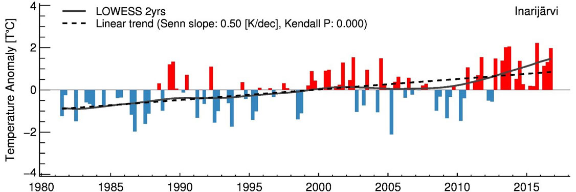
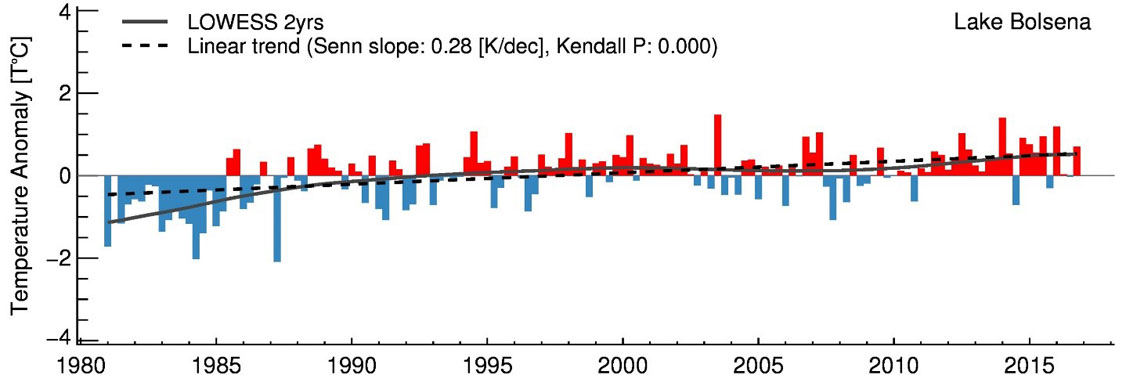
"As you can see in the image showing Lake Bolsena, the period from 1981 to 1987 is essential for the retrieval of a climate induced signal," says Stefan Wunderle, Head of the Remote Sensing Research Group and co-author of the paper. "During this period we had colder conditions, which were also observable in the temperature of ground water or in the number of snow days in lower elevations. The longer time series based on AVHRR data, therefore, give us a more detailed view of the effect of climate change on many essential climate variables."