- Campaigns
- SnowSAR Proof Of Concept
SnowSAR Proof Of Concept
Overview
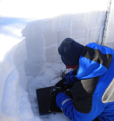
Finnish Meteorological Institute making
measurements of snow and ice properties
in a snow pit
What was the purpose of SnowSAR?
The SnowSAR field campaign forms part of the activities supporting the development of the Cold Regions Hydrology High-resolution Observatory (CoReH2O) mission. This was one of three candidate Earth Explorers undergoing a feasibility study.
The main objective of the SnowSAR campaign was the provision of radiometric calibrated airborne SAR data needed to characterise the backscattering signatures of snow and other terrain types (e.g. trees).
What was the outcome of SnowSAR?
SnowSAR provided, for the first time ever, coincident X- and Ku- SAR image data of land cover and snow fields from an airborne platform by using an instrument similar to that studied for ESA's CoReH2O satellite.
The preliminary results confirm the internal stability and reliability of the SnowSAR instrument and indicate its suitability for investigations about the backscattering signatures of snow and of Arctic landscapes in general.
These results help pave the way to understanding how radar could map the water content of snow from space.
Download the SnowSAR Final Report
| Year | 2011 |
| Geographic Site | Lapland (Finland) |
| Field of Applictaion | X- and Ku-Band SAR imagery |
| Data Size | 0.4GB |
Digital Object Identifier: https://doi.org/10.5270/esa-0b05hs0 - SnowSAR POC (Proof Of Concept): "Technical Assistance for the Development and Deployment of an X- and Ku- Band MiniSAR Airborne System "
Data
The campaign data is available online via FTPS upon submission of a data access request. An active EO Sign In account is required to submit the request.
The data can be downloaded via an FTP client (e.g., FileZilla or WinSCP) using the option "Implicit FTP over TLS".
For further information about the EO Sign In Service you can visit TellUs
Should you need support please contact EOHelp