- Campaigns
- POLARIS Proof of Concept 2008
POLARIS Proof of Concept 2008
Overview
What was the purpose of POLARIS Proof of Concept 2008?
While the a Functional Test Flight (FTF) was an instrument test, the Proof-of-Concept (PoC) campaign primarily aimed to verify the usefulness of the system for glaciological applications.
The PoC campaign took place in Greenland in May 2008, where surface melting is not yet an issue and where the weather conditions are more attractive during the Arctic winter.
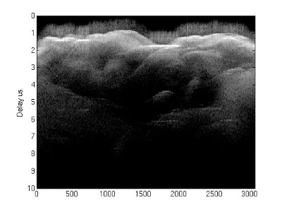
What was the outcome of POLARIS Proof of Concept 2008?
In combination with the FTF the POLARIS system was successfully integrated with the Twin Otter aircraft and the EMI test was carried out. The system functionality was tested and even if a number of errors were identified the first POLARIS image could be produced.
Download the POLARIS Proof of Concept 2008 Final Report
| Data Coverage (Year) | 2008 |
| Geographic Site | Greenland |
| Field Applicaion | P-Band ice sheet sounding |
| Data Size | More than 50 GB |
Digital Object Identifier: https://doi.org/10.5270/esa-71tv6gn - POLARIS Proof-of-Concept 2008: "P-Band Ice Sounding Radar Demonstrator Development; Campaign Report"
Data
The campaign data is available online via FTPS upon submission of a data access request. An active EO Sign In account is required to submit the request.
The data can be downloaded via an FTP client (e.g., FileZilla or WinSCP) using the option "Implicit FTP over TLS".
For further information about the EO Sign In Service you can visit TellUs
Should you need support please contact EOHelp