- Campaigns
- ESAG
ESAG
Overview
What was the purpose of ESAG?
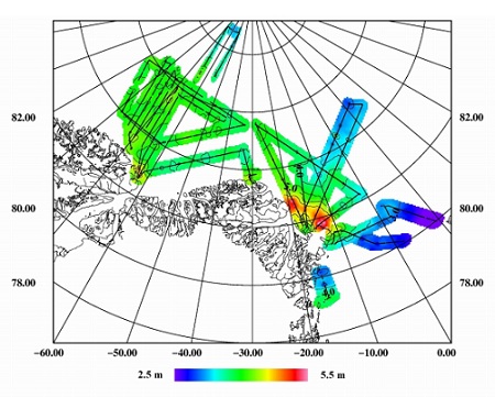
The purpose of the European Survey of Arctic Gravity (ESAG-2002) field campaign was:
- To acquire high-accuracy airborne gravity measurements of the Arctic Ocean, in support of ESA's GOCE mission, filling in voids in the existing gravity coverage in the polar region and providing control ties to older gravity surveys in the region.
- To acquire scanning laser ranging (lidar) data and profiling laser altimetry over the sea-ice north of Greenland, as a mean of measuring ice elevations, to provide background data in preparation for the ESA CryoSat mission.
What was the outcome of ESAG?
The ESAG-2002 airborne gravity and lidar data survey was highly successful, with close to 100% data recovery. Only few tracks did not yield useful laser data due to fog and low clouds. Auxiliary data including airborne video and ship-borne web cam ice images may further enhance the usefulness of the laser data, and aid in understanding radar remote sensing signatures.
The ESAG-2002 airborne gravity survey have filled an important gravity void in the Arctic Ocean, and will allow an intercomparison of older US, Canadian and German gravity surveys in the region, in order to detect possible systematic long-wavelength errors, which might degrade polar gap supplementary data for GOCE.
Download the ESAG 2002 Final Report
| Data Coverage (Year) | 2002 |
| Geographic Site | Greenland, Svalbard |
| Field of Application | Gravity field |
| Data Size | 14 |
Digital Object Identifier: https://doi.org/10.5270/esa-ejqf32r - ESAG: "European airborne gravity and lidar survey in the Arctic Ocean"
Data
The campaign data is available online via FTPS upon submission of a data access request. An active EO Sign In account is required to submit the request.
The data can be downloaded via an FTP client (e.g., FileZilla or WinSCP) using the option "Implicit FTP over TLS".
For further information about the EO Sign In Service you can visit TellUs
Should you need support please contact EOHelp