- Campaigns
- BorealScat
BorealScat
Overview
What was the purpose of BorealScat?
The main objective of “BorealScat – Technical Assistance for the Deployment of a Tower-based Radar and Geophysical Measurements during the BorealScat Experiment” was to characterise and quantify the temporal variations of radar observations of a forest stand over timescales ranging from seconds to years and to investigate the effects of environmental variables.
During the campaign, tower-based multi-polarisation, tomographic radar observations were made over the Remningstorp forest site in southern Sweden for more than a year with five-minute intervals. Together with the antenna array multi-polarisation, tomographic radar images of the forest were acquired at P-, L- and C-band. A weather station was also installed on site.

More specifically, the main objectives of the BorealScat campaign were:
- Acquisition of polarimetric, tomographic radar measurements at P-, L- and C-band over a boreal or hemi-boreal forest site to enable the analysis of temporal radar signatures in sparse forest and a highly dynamic environment including snow, freeze/thaw and leaf/needles on/off cycles
- Provide fundamental information of radar scattering mechanisms as a function of time and support the design of forest biomass retrieval algorithms at the different frequencies and using different techniques
- The long-term characterization of scattering signatures (intensity, phase and coherence) and scattering mechanisms on P/L/C-band over boreal forest on scales ranging from daily, weekly and monthly to yearly
- Coherence statistics as a function of time, environmental conditions and location within the canopy
- The identification and characterization of the main environmental effects (e.g., moisture, freezing etc.) on the radar signatures
- The validity of scattering models to characterize boreal forests as well as possible mitigation schemes to correct for nuisance effects (such as moisture variations).
What was the outcome of BorealScat?
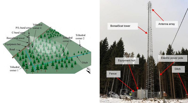
The BorealScat experiment carried out temporally dense radar observations of a hemi-boreal forest site at P- (435 MHz), L- (1270 MHz) and C-band (5400 MHz) at all four linear polarisation transmit-receive combinations (HH, HV, VH and VV). Two antenna arrays at the top of the 50-meter high tower allowed tomographic imaging of the forest below, separating scatterers at different heights within the forest.
Doppler measurements were also performed at P-, L-, and C-band. The radar design was based on a 20-channel vector network analyser (VNA) which was connected to the antennas via low-loss cables and diplexers. Trihedral corner reflectors were used for external calibration. A full measurement cycle was repeated every 5 minutes. The reported measurements started in December 2017 and stopped in August 2021.
The observed forest site was a mature, homogeneous Norway Spruce stand located at (58°27'05" N, 13°37'35" E) in the Remningstorp experimental forest west of the city Skövde in southern Sweden. The above-ground dry biomass was 250 tons/ha and the tree heights varied from 25 to 27 m. The facility included a weather station and moisture sensors in the forest.
The dataset provides a unique opportunity to study the effects of environmental variables on radar observations, the electromagnetic scattering and the steps that can be taken to improve scattering models and forest parameter estimation algorithms to mitigate these effects.
Download the BorealScat Final Report
Download the BorealScat-contract-change-notice-Final-Report
| Data Coverage (Year) | 2017 - 2021 |
| Geographic Site | Remningstorp, Sweden |
| Field of Application | P-, L- and C-band Radar Tomography |
| Release Date | February 2023 |
Digital Object Identifier: European Space Agency, 2023, BorealScat - Technical Assistance for the Deployment of a Tower-based Radar and Geophysical Measurements during the BorealScat Experiment, https://doi.org/10.57780/esa-e071d3d
Data
The campaign data is available online via FTPS upon submission of a data access request. An active EO Sign In account is required to submit the request.
The data can be downloaded via an FTP client (e.g., FileZilla or WinSCP) using the option "Implicit FTP over TLS".
For further information about the EO Sign In Service you can visit TellUs.
Should you need support please contact EOHelp.