- Campaigns
- AgriSAR 2009
AgriSAR 2009
Overview
What was the purpose of AgriSAR 2009?
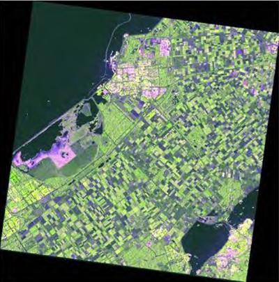
The AgriSAR 2009 campaign was defined to leverage the RADARSAT-2 mission to better understand and demonstrate the potential for GMES land monitoring user services, particularly in agriculture, based on time series of C-band SAR data from the Sentinel-1 mission.
What was the outcome of AgriSAR 2009?
Over the 2009 growing season RADARSAT-2 polarimetric data were acquired twice weekly over three diverse agriculture test sites at Barrax, Spain, Flevoland, The Netherlands and Indian Head, Saskatchewan. RapidEye optical images were also acquired over each test site. Ground surveys were conducted to provide extensive crop maps as well as crop details for selected representative fields. The RADARSAT-2 data were used to simulate Sentinel-1 Interferometric Wide Swath mode dual-pol SLC and GTC products and quad-pol GTC products at equivalent resolution. Nearly 1000 products were simulated.
Download the AgriSAR 2009 Final Report
| Data Coverage (Year) | 2009 |
| Geographic Site | Barrax (E) Flevoland (NL) Indian Head (CDN) |
| Field of application | Simulated Sentinel-1 SAR imagery for agricultural monitoring |
| Data size | More than 50 GB |
Digital Object Identifier: https://doi.org/10.5270/esa-jdg5o4g - AgriSAR 2009: "Final Report Vol1 Executive Summary, Data Acquisition, Data Simulation"
Data
The campaign data is available online via FTPS upon submission of a data access request. An active EO Sign In account is required to submit the request.
The data can be downloaded via an FTP client (e.g., FileZilla or WinSCP) using the option "Implicit FTP over TLS".
For further information about the EO Sign In Service you can visit TellUs
Should you need support please contact EOHelp