- All Categories (30523)
- Data (134)
- News (281)
- Missions (41)
- Events (75)
- Tools (40)
- Activities (47)
- Campaigns (32)
- Documents (29873)
News - Data Release news
Cryo-TEMPO gets new Summer Sea Ice product
CryoSat’s remarkable 14-year record of global ice and sea levels got another upgrade with the release of Cryo-TEMPO baseline C, which includes lots of new features and improvements.
Data - Sample Data (Open)
TerraSAR-X Sample Data
Download free TerraSAR-X sample datasets to preview products available for this mission.
News - Data Release news
New Ocean data and more boost CryoSat data platform
Eight new datasets have been added to the CS2EO platform to support, enhance, and simplify research using CryoSat data. They include the CryoSat Ocean Product, and the Cryo-TEMPO Land Ice, Sea Ice, Polar Ocean, Coastal Ocean and Inland Water datasets.
News - General News
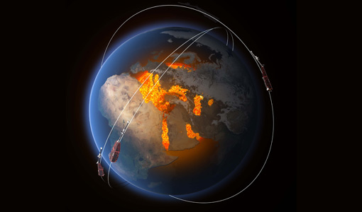
Earth scientists better exploit Swarm data with virtual workspace
The ESA-funded Swarm virtual workspace is helping scientists make the most of a decade of valuable magnetic field data.
News - General News

ESA's improved Earth system data records: what is in store for the future?
Fundamental Data Records (FDRs) are instrumental in advancing our understanding of Earth systems and for addressing societal challenges effectively. These long-term records contain uncertainty-quantified, calibrated and geo-located multi-instrument/multi-platform satellite sensor data spanning several decades to support climate-related applications.
News - Maintenance News

ESA data dissemination maintenance – 10 April 2024
A planned software maintenance activity will affect ESA’s ERS and Envisat (A)SAR data dissemination service on 10 April 2024.
News - General News

New Swarm Field Aligned Current web tool available
We are pleased to announce that a new Field Aligned Currents (FAC) web tool is available
News - How to guides
HEDAVI Discover: a step-by-step guide
The Heritage Data Visualisation tool (HEDAVI) is a platform developed by the French Science Consulting for Earth Observation group, VisioTerra, which allows users to freely access over 40 years of ESA Earth Observation Heritage data, Third Party Missions and some Copernicus data.
News - Success Stories
Ten years of Swarm data help reveal processes in Earth’s core
The tenth birthday of ESA’s three-satellite Swarm constellation has been a game changer for research into Earth’s magnetic field and core dynamics, as set out by an ESA-funded project.
News - Data Release news
CHAMP L3 magnetic data now available on Swarm dissemination server
We are pleased to announce the release of magnetic field data from CHAMP mission on Swarm dissemination server.
News - Data Release news

ICEYE Dwell mode now available to users
ICEYE Dwell mode products are now available through ESA’s Third Party Missions programme.
Tools - Catalogues
CS2EO
CS2EO is a data catalogue that allows users to easily and quickly combine and download airborne and spaceborne altimetry data from CryoSat-2, ICESat-2, CryoVEx, IceBridge and CryoTEMPO-EOLIS.
News - Announcement of Opportunity updates

Announcement of Opportunity for SAOCOM – deadline extended
The submission deadline for the ESA/CONAE Announcement of Opportunity for SAOCOM mission data has been extended until 31 December 2024.
News - Operational News
Transition from FTP to FTPS for SMOS, Aeolus and Campaign data dissemination systems
As of 15 April 2024 access to the SMOS, Aeolus and Campaign data will be changed from simple FTP to FTPS.
News - Success Stories
How scientists are unlocking the potential of SAOCOM
A team of scientists has drawn on SAOCOM data to measure the heights of forests in Argentina, marking the first time that tree canopies have been mapped using the two-satellite constellation.
News - Data Release news
Additional EFI TII Cross Track Flow dataset 0302 available for Swarm
Additional TII cross-track flow data is now available on the Swarm dissemination server for all the Swarm satellites.
News - Data Release news
FDR4ALT - ESA unveils new cutting-edge ERS/Envisat Altimeter and Microwave Radiometer Datasets
The European Space Agency (ESA) has developed a comprehensive suite of innovative Earth system data records as part of the Fundamental Data Records for Altimetry project - FDR4ALT.
News - Success Stories
Magnetic magic: 10 reasons to be excited about Swarm
In November 2023, Swarm celebrated an impressive ten years in orbit. In that time, ESA’s magnetic mission has honed in on all sorts of mysteries - from tussling magnetic blobs to animal migration.
Data - EO Sign In Authentication (Open)

Fundamental Data Records for Radiometry [MWR_FDR___]
This dataset is a Fundamental Data Record (FDR) resulting from the ESA FDR4ALT project. The Fundamental Data Record for Radiometry V1 products contain intercalibrated Top of the Atmosphere brightness temperatures at 23.8 and 36.5 GHz. The collection covers data for the ERS-1, ERS-2 and Envisat missions, and is built upon a new processing of Level 0 data, incorporating numerous improvements in terms of algorithms, flagging procedures, and corrections. Compared to existing datasets, the Radiometry FDR demonstrates notable improvements in several aspects: New solutions for instrumental effects (ERS Reflector loss, Skyhorn, and Sidelobe corrections) Native sampling rate of 7Hz with enhanced coverage The FDR4ALT products are available in NetCDF format. Free standard tools for reading NetCDF data can be used. Information for expert altimetry users is also available in a dedicated NetCDF group within the products. Please consult the FDR4ALT Product User Guide before using the data. The FDR4ALT datasets represent the new reference data for the ERS/Envisat altimetry missions, superseding any previous mission data. Users are strongly encouraged to make use of these datasets for optimal results.
Data - EO Sign In Authentication (Open)

Fundamental Data Records for Altimetry [ALT_FDR___]
This dataset is a Fundamental Data Record (FDR) resulting from the ESA FDR4ALT project. The Fundamental Data Record for Altimetry V1 products contain Level 0 and Level 1 altimeter-related parameters including calibrated radar waveforms and supplementary instrumental parameters describing the altimeter operating status and configuration through the satellite lifetime. The data record consists of data for the ERS-1, ERS-2 and Envisat missions for the period ranging from 1991 to 2012, and bases on the Level 1 data obtained from previous ERS REAPER and ENVISAT V3.0 reprocessing efforts incorporating new algorithms, flags, and corrections to enhance the accuracy and reliability of the data. For many aspects, the Altimetry FDR product has improved compared to the existing individual mission datasets: New neural-network waveform classification, surface type classification, distance to shoreline and surface flag based on GSHHG Instrumental calibration information directly available in the product Improved Orbit solutions Correction of REAPER drawbacks (i.e., time jumps and negative waveforms) The FDR4ALT products are available in NetCDF format. Free standard tools for reading NetCDF data can be used. Information for expert altimetry users is also available in a dedicated NetCDF group within the products. Please consult the FDR4ALT Product User Guide before using the data. The FDR4ALT datasets represent the new reference data for the ERS/Envisat altimetry missions, superseding any previous mission data. Users are strongly encouraged to make use of these datasets for optimal results.