- News
- Using Satellite Data to Predic...
Using Satellite Data to Predict Floods and Droughts
22 Dec 2020
In the last decades, as climate change continued to increase the risk of floods and extreme droughts, a need to develop models for monitoring wetlands and river ecosystems, especially in vulnerable areas, arose. Hydrological models can be used not only to monitor the health of rivers, but also to predict floods and support the sustainable development of human-made projects such as new dams. However, many areas around the world lack in-situ observations of surface water dynamics. Scientists are therefore turning to remote sensing to fill the data gap and improve hydrological-hydrodynamic models.
During her PhD at the Department of Environmental Engineering of the Technical University of Denmark (DTU), Cécile Kittel investigated whether Earth Observation satellite data can supplement ground-based measurements in hydrological monitoring and modelling and how they can best be integrated, not only in models, but also in hydrological tools that can be easily accessed and applied.
Her work was funded through two ESA projects, GlobWetland Africa and Earth Observation for Sustainable Development. Consultancy company DHI GRAS, which works with satellite data and water regulation projects around the world, also collaborated on her research.
"In recent years, vast amounts of new satellite data have become publicly available, offering a myriad of new possibilities," explains Cécile Kittel. "The aim of my research was to explore the value of new radar missions for hydrologic monitoring and modelling. It centred on developing a full workflow, from rainfall-runoff model to hydrodynamic simulations of channel water level, for poorly instrumented catchments, using satellite radar observations to inform the models at different stages."
Hydrodynamic models can be used to predict floods, but adequate hydraulic representation of rivers is necessary to produce simulations that can serve as valuable support for decision-making and management, particularly in regions with weak in-situ monitoring networks. By using altimetry data, scientists can check how a model is performing, if the representation of the model or the slope of the channel is captured correctly. If there are no observations, they rely on digital elevation models, but altimeter data are more precise.
Five Rivers in Africa
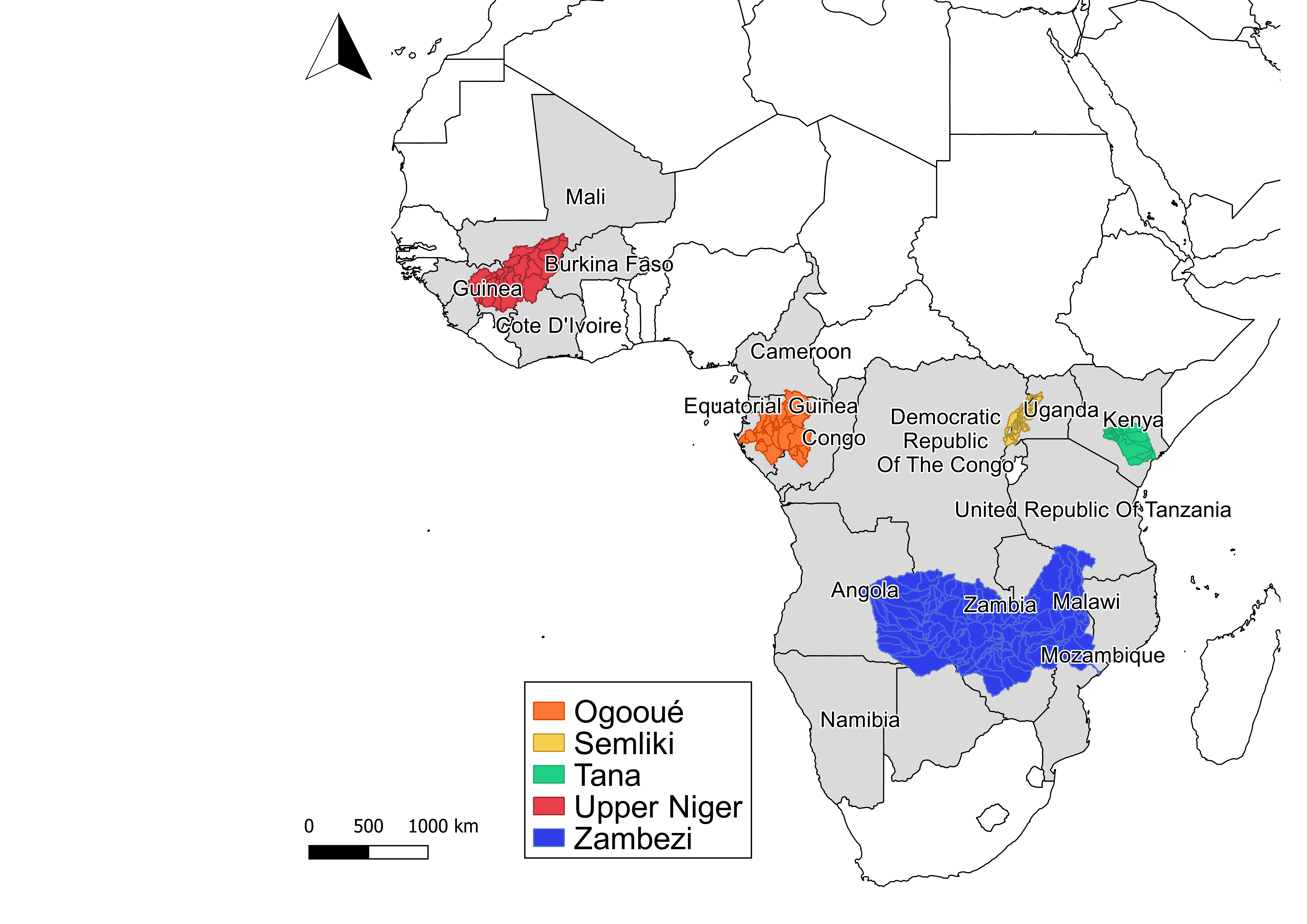
Kittel's research focused on five African rivers with very few in-situ observations: the Ogooué, Semliki, Upper Niger, Tana, and Zambezi. The rivers were chosen because they cover several parts of the African continent and are different in terms of networks, geography and climate.
The first river she looked at was the Ogooué in Gabon. Kittel used Envisat and Jason-2 data from the Hydroweb database, as well as CryoSat-2 and GRACE data to get an idea of how much water was stored in the catchment. Her research produced the first numerical model of the Ogooué catchment, which can potentially be used to look at simulations of the impact of changes such as temperature increases or drops in precipitation or flood predictions.
"With Envisat and Jason-2 it's the continuity that makes the data useful, because in many of these catchments the altimetry dataset offers a unique level monitoring network that would otherwise not have been possible, due to a lack of ground stations and the financial and physical effort needed to maintain them," says Kittel. "The same applies to CryoSat-2 that has been operational for 10 years now."
By the time she expanded her research to the Semliki, Upper Niger and Tana rivers, ESA had successfully launched Copernicus Sentinel-3 and its data had become publicly available. Kittel opted to switch from Envisat and Jason-2 to Copernicus Sentinel-3 as soon as there were enough data available for her research, but continued to work with CryoSat-2 data. Copernicus Sentinel-3 was the first altimetry mission to operate in SAR mode and to offer an improved instrument and open-loop tracking mode near-globally.
For the Zambezi River, Kittel used Copernicus Sentinel-3 and CryoSat-2 data. She created a Copernicus Sentinel-3 water surface elevation monitoring network with the observations available at around 150 virtual stations, calibrated a hydraulic model using CryoSat-2 data and then used Copernicus Sentinel-3 data as a benchmark for performance, when no other observations were available.
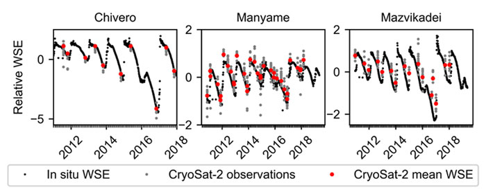
The Zambezi River also allowed Kittel to validate satellite data against ground-based observations at five locations. Copernicus Sentinel-3 outperformed past altimetry missions at in-situ stations, with deviations sometimes as low as 3 cm and consistently lower than 32 cm.
CryoSat-2 and hydraulic models
CryoSat-2 was originally designed for monitoring the cryosphere and was the first mission to operate in the high resolution modes SAR/SARIn over selected areas of interest. In hydrology, dense spatial sampling helps detect smaller scale variations in rivers, such as channel roughness, which determines how much water is needed to produce a certain discharge. This can change at smaller scale and having close observations along the river line provides more detailed information.
"The spatial sampling from CryoSat-2 really adds value to hydraulic simulations for poorly gauged catchments," says Kittel. "This type of datasets, that are not necessarily produced for hydrology can offer a lot of useful information for research like mine. I collaborated with the Hydrology Group of the School of Geographical Sciences at the University of Bristol, to combine CryoSat-2 Water Surface Elevation data with a steady-state hydraulic model of the river channel, and developed a new and efficient hydraulic model parameter calibration approach for spatially distributed parameters. This allowed us to simulate channel flow more accurately."
Cécile Kittel's research highlights the value of radar observations and data continuity in hydrological monitoring and modelling applications, particularly in poorly gauged catchments where altimetry might provide the only water level information.
By developing tools specifically adapted to the varying sampling patterns of altimetry missions, hydrological predictions can be improved. Kittel's model structure has already been implemented in the GlobWetland Africa toolbox, where it has proved a success.