- News
- New reprocessing of datasets c...
New reprocessing of datasets celebrates 30 years of ERS
22 Jul 2021
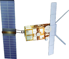
The ERS programme celebrated its 30th anniversary on 17 July. The landmark ERS-1 satellite, launched on 17 July 1991, pioneered the use of ESA’s Earth observation technology and applications that would follow with ERS-2 and ERS’ successor missions, including Envisat and the Copernicus Sentinels.
Today, we are still exploiting ERS data and experts continue to work on improving the altimeter, radiometer and SAR data the programme acquired. This is achieved through two projects.
The Fundamental Data Records for Altimetry (FDR4ALT) project aims to generate innovative Earth system data records, called Fundamental Data Records (basically level 1 altimeter and radiometer data) and Thematic Data Records (basically level 2P geophysical products), in the frame of ESA’s Heritage Space Programme (LTDP+).
These products will be based on the exploitation of measurements acquired by the altimeter and radiometer instruments onboard the ERS and Envisat satellites.
The goal is to serve the different communities involved in long-term data exploitation over the different Earth surfaces: ocean, coastal, inland water, ice sheets, sea ice and atmosphere.
FDR4ALT is led by CLS (Collecte Localisation Satellites), and is composed of a large consortium of experts from all around Europe. For each surface, the experts will use our current knowledge acquired over 30 years of experience, to improve the ERS altimetric and radiometric data as much as possible.
FDR4ALT final products will be available at the end of 2022. Find out more about the project.
The SAR ARD project aims to generate a new SAR product, processed to a minimum set of requirements and organised into a form that allows immediate analysis with a minimum of additional user effort and interoperability both through time and with other datasets.
The project also plans to improve the SAR algorithm, including usage of the new Copernicus DEM (Digital Elevation Model), the Radiometric Terrain Correction and to improve the current geolocation accuracy.
This project follows the Sentinel-1 and Sentinel-2 ARD products approach, to be able to extend the SAR database to also include ESA Heritage Missions like ERS, and to allow the interoperability between different instruments, and between operational and completed missions.
Through these reprocessing activities, data from ESA's first dedicated Earth observation mission continues to be relevant today, and offers valuable long-term references for ongoing studies in a wide range of fields.