- News
- ICEYE data familiarization pha...
ICEYE data familiarization phase for the Earthnet TPM programme continues with new ICEYE-X2 data
01 Mar 2019
The ICEYE data familiarization phase freely offers ICEYE imagery over several demonstration sites and is continuing this by presenting to the user community the new ICEYE-X2 products in place of older ICEYE-X1 data: this data is more representative of higher quality achieved by the new ICEYE microsatellite.
ICEYE-X2 features a range of technology improvements to increase the versatility and quality of the imaging data compared to ICEYE-X1. Improvements relate to items such as component choices, subsystem interfaces, software code, operations procedures, communication links, and optimisation of power management. ICEYE-X2 possesses various imaging modes to provide imagery at high resolution and alternatively with a very wide swath to support different types of use cases.
The data will be accessible directly via the ICEYE delivery system. This can also be reached via the ICEYE product description and detailed information about the satellite is also available.
ICEYE-X2 Satellite and Data
ICEYE-X2 was launched in December 2018. It has three imaging modes (Stripmap, Scansar, Spotlight), 35 km swath width and spatial resolution of 3 m for SM, 20 m for SC, 1 m for SL.
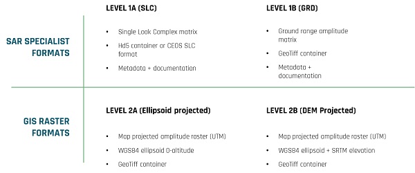
Main products are summarised in below image:

Data offer
Through the data familiarization SAR ORTHO products (level 2A) acquired in Stripmap mode are made available: this product is represented by a single Geotiff file that contains information about backscatter amplitude from each ground resolution cell, projected into a map coordinate system, compatible with modern GIS toolchains.
Altogether six demonstration sites are offered for the data quality assessment focusing on several potential applications such as urban, agricultural and vessel tracking.
Las Vegas (Acquisition date: 6 January 2019) and Tanzania over Zanzibar (21 January 2019) as urban test sites; Argentina near Cordoba (22 January 2019), Argentina near Rosario (13 January 2019), Vietnam with Ho Chi Minh City included (10 January 2019) as example of agricultural site; Vessel tracking test site is represented by a frame over Tokyo bay (27 December 2018).