- News
- GEOSS Portal now more user-ori...
GEOSS Portal now more user-oriented
14 Sep 2020
The recently completed ESA managed project EDGE (European Direction in GEOSS Common Infrastructure Enhancements), co-funded by the European Commission DG RTD under grant no 776136, has developed into being more results- and user-oriented, now offering to experiment discovery, access and use of information and services, thus allowing stakeholders to acquire relevant knowledge to make well-informed decisions.
The GEOSS Portal is a unique internet access point for Earth observations worldwide. Until recently, the main focus of the portal, as an integral part of the GEOSS Platform, was data-centric.
Since early 2005, ESA has been a member of the Group on Earth Observations (GEO). This is a partnership comprising 100 national governments and over 100 participating organisations who envision a future where decisions and actions are informed by coordinated, comprehensive and sustained Earth observations, for the benefit of humankind.
Nowadays, one of ESA's main roles regards the evolution and operations of the GEOSS Portal, already implementing quite a number of practical examples involving relevant stakeholders from EC, ESA, GEO and other initiatives, covering different and cross thematic areas, including Climate Change, Disaster Risk Reduction, Sustainable Development Goals (SDG), and many others.
EDGE started in October 2017 and ended in May 2020, with the main objective of evolving two of the GEOSS Platform components, namely the GEOSS Portal and the Discovery and Access Broker (GEO-DAB) – the latter implemented and operated by the Italian National Research Council (CNR-IIA) - it also provided valuable inputs to the GEOSS Infrastructure Development Task Team (GIDTT) for further evolving GEOSS at large. It is this team that shall additionally look into how to further evolve GEOSS.
The GEOSS Platform was enhanced following a user-centric approach, involving relevant stakeholders via a series of dedicated workshops (e.g. GEO Data Provider and User Community) and direct connections. In total, 40 scenarios and over 100 requirements for evolving the GEOSS Platform and GEOSS at large were identified.
Based on these requirements collection, a range of new EO resources are now accessible to users. In the last two years, 33 new data sources were connected and another 22 were updated.
In addition, new access protocols have been implemented and graphical visualisation (the GUI) was enhanced – e.g. with icons, panels, layers, maps. Filtering, based on sophisticated and community-specific search criteria via views has been evolved, with tools for developers introduced (e.g., APIs, Widgets and Mirror Sites), user feedback mechanism improved, coupling with social media and collaboration mechanisms to enhance engagement with users.
In particular, in situ data were targeted to complement the already extensive satellite-based collection of datasets. The GEOSS Platform currently connects 192 data sources, with 83 of them providing non-satellite datasets, and another 74 providing both satellite and non-satellite datasets.
Josef Aschbacher, Director of the Earth Observation Programmes directorate in ESA, considers the followed user-centric approach most relevant for best responding to what the user actually needs, "This contribution to GEO shows our common interest and potential of European collaboration and Earth observation for the benefit of Earth."
Considering it from different perspectives, EDGE evolved the Platform in various ways. For instance, type of resources (data, information, services, knowledge), functional or capabilities (discovery, access, use), from types of communities (different and cross thematic areas) and users (developers, value adders, data scientists, application scientists, decision- and policy makers), application (generation of knowledge, reproducibility of science, monitoring, prevention, comparison, etc.), scale (local, regional, global), number of resources available, graphical display, user experience and so on.
Following are some examples illustrating such developments. They refer to the EDGE documentation, which provides an overview of all implemented examples.
1. Search for Natural Phenomena and Inspection on Map
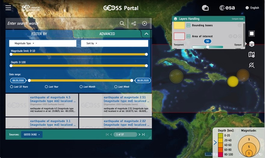
Search for earthquakes with specific search criteria and application of filters for magnitude range, depth and date range, and visualisation of chosen layers on a map with legends.
Enhanced:
- Resource registration
- Graphical display customised for specific communities and users
- Search and filter capabilities using views
See: Experiment access to earthquakes
2. Support to Implementation of UN Agenda for Sustainable Development

Search for SDG 15 Land Degradation, exploration of related targets and indicators, access and inspection of related services, computation of results and comparison with results from other sources, in this case with official values provided by the UN Statistics Division.
- Search and navigation across different types of resources (data, information, services)
- Linked information
- Service execution and linking to cloud resources (e.g. DIAS)
- Graphical display.
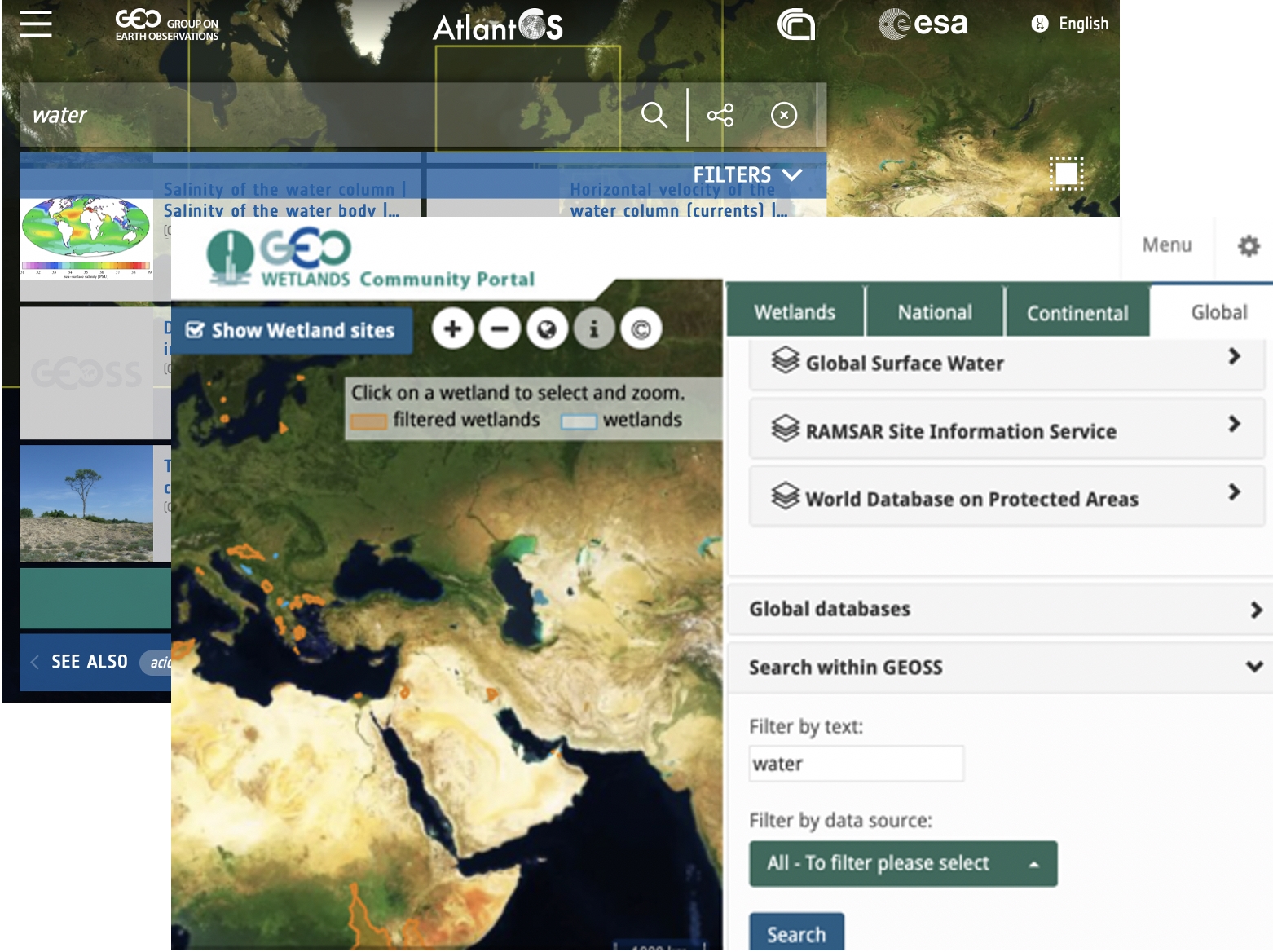
3. Enabling Reuse and Customisation of GEOSS Platform Capabilities by Developers
See:
- Video: search for SDG 15 and navigation to targets and indicators
- Video: Use of European Model Trends
- Experiment the European Model: Login and run it.
- Experiment search navigate down to targets and indicators
- Knowledge generation using satellite earth observations to support sustainable development goals.
Search and access to data and other resources from community portals either starting from scratch or integrated into an existing portal customised to the specific needs of the relevant community and users.
Enhanced:
- GEOSS Platform reuse capabilities both available as widgets and as mirror sites
- GEOSS Platform community specific filter capabilities via views and enhanced graphical display.
See:
The set of experimented examples considers GEO Flagships (GOS4M, Sen2Agri), GEO Initiatives (GEO Essential, GEO-GNOME, GTN-H), GEO Community activities (Envidat, AtlantOS), Copernicus Services, ESA Exploitation Platforms, Regional GEO's (AmeriGEO, EuroGEO, DBAR/AOGEO), EC H2020 projects, ERA-PLANET activities and various other initiatives. Operationally available results are already implemented in the GEOSS Portal. Proofs of concepts can be accessed for a short period of time. Relevant EDGE deliverables are available via the GEO web-site.
Contacts:
- European Space Agency: Joost van Bemmelen – email: Joost.van.Bemmelen@esa.int, Guido Colangeli – email: g.colangeli@rheagroup.com
- CNR-IIA: Paolo Mazzetti – email: paolo.mazzetti@cnr.it
- EC DG JRC: Stefano Nativi – email: Stefano.NATIVI@ec.europa.eu
Links:
- Proofs of Concept (also available via GEOSS Portal – Hamburger menu)
- EDGE deliverables available from GEO website news: "Visit the newly enhanced GEOSS Platform with improvements from project EDGE" 7 September 2020
- Knowledge generation using satellite Earth observations to support sustainable development goals (SDG): A use case on Land degradation, G. Giuliani, P. Mazzetti, M. Santoro, S. Nativi, J. van Bemmelen, G. Colangeli, A. Lehmann, International Journal of Applied Earth Observation and Geoinformation, Volume 88, 06.2020.