- News
- CryoSat - Geographical Mode Ma...
CryoSat - Geographical Mode Mask 4.0 released
12 Sep 2019
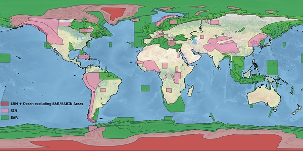
A new CryoSat Geographical Mode Mask (v 4.0) is operational from Week 34 2019 (19 August - 26 August) onwards. The mask is the basis of the CryoSat mission planning and defines the mode switching of the SIRAL instrument while the satellite revolves around the Earth.
- Synthetic Aperture Radar (SAR) (green) is operated over sea-ice areas and over some ocean basins and coastal zones.
- SAR Interferometric (SARIn) (purple) mode is used over steeply sloping ice-sheet margins, over some geostrophic ocean currents and over small ice caps and areas of mountain glaciers. It is also used over some major hydrological river basins.
- Low Resolution Mode (LRM) is operated over areas of the continental ice sheets (red), over oceans and over land not covered by other modes.
