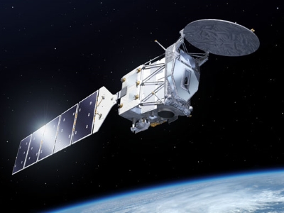
- EarthCARE
- Mission
- EarthCARE Objectives
EarthCARE Objectives
The objective of the EarthCARE mission is to make global observations of clouds, aerosols and radiation.
To achieve this challenging objective the satellite will carry four scientific instruments and circle Earth in a Sun-synchronous polar orbit crossing the equator in the early afternoon to optimise daylight conditions.
EarthCARE aims to quantify cloud-aerosol-radiation interactions so they may be included correctly in climate and numerical weather forecasting models.
The mission will achieve these objectives by measuring globally the vertical structure and horizontal distribution of cloud and aerosol fields together with outgoing radiation.
The scientific objectives of the mission are:
- To observe vertical profiles of natural and anthropogenic aerosols on a global scale, their radiative properties and interaction with clouds
- To observe vertical distributions of atmospheric liquid water and ice on a global scale, their transport by clouds and their radiative impact
- To observe cloud distribution, cloud-precipitation interactions and the characteristics of vertical motions within clouds
- To retrieve profiles of atmospheric radiative heating and cooling through the combination of the retrieved aerosol and cloud properties
The mission will achieve these objectives by measuring globally the vertical structure and horizontal distribution of cloud and aerosol fields together with outgoing radiation.
Specifically, EarthCARE will measure:
- Properties of aerosol layers: occurrence, extinction profiles, boundary layer height, distinction of aerosol types
- Properties of cloud fields: cloud boundaries and multilayer clouds, height-resolved fractional cloud cover and overlap, occurrence of liquid/ice/super-cooled layers, vertical profiles of ice water content and effective particle size, vertical profiles of liquid water and effective droplet size, and small-scale (<1 km) fluctuations of these properties.
- Vertical velocities to characterise cloud convective motion and ice sedimentation
- Drizzles rain rates and estimates of heavier rainfall rates
- Reflected solar and emitted thermal radiances at the top of the atmosphere
Science
This video describes the scientific objectives of the upcoming EarthCARE mission, and how the mission will achieve its goals.
Incoming sunlight fuels our climate. It covers the ultraviolet spectrum, peaks in the visible and extends into the shortwave infrared, to wavelengths of about 4 micrometre. Part of the radiation is absorbed, scattered and reflected inside the atmosphere before it reaches Earth's surface. Clouds partly shield the surface from solar radiation by reflecting radiation back into space.
Earth emits thermal infrared radiation into space, cooling the planet. Also thermal radiation is reflected by clouds, trapping outgoing thermal radiation, which leads to heating. Whether the net effect results in cooling or heating, depends on the microphysical and 3D structure of the cloud.
The properties of clouds and their extent vary enormously. They range from almost invisible thin layers, yet radiatively significant, to deep cumulonimbus towers or huge cyclone systems. Through their direct impact on atmospheric heating rates, they are strongly coupled to atmospheric temperature, humidity and dynamics.
Put simply, an increase in atmospheric temperature might lead to higher rates of water evaporation and increased convective activity, which would lead to increased cloud formation, in turn, leading to higher reflection of incoming solar radiation. Comprehensive global observational datasets of the 3D structure and composition of clouds are necessary to improve our understanding of these processes to model them properly in numerical atmospheric models.
Aerosols play a smaller role in atmospheric radiation compared to clouds, but certain aerosols act as cloud condensation nuclei necessary for the formation of clouds. It is important to quantify and distinguish between different types of atmospheric aerosol in the context of cloud research.
Finally, the measured clouds and aerosols needs to be linked to atmospheric radiation. For this purpose, the observed scenes of clouds and aerosols need to be complemented by measurements of the reflected solar and emitted thermal radiation.
EarthCARE will collect global simultaneous observations of cloud and aerosol profiles together with solar and thermal radiation to include these parameters in numerical weather and climate models.
As an added benefit, EarthCARE aerosol data will be valuable for air-quality analyses and services. EarthCARE cloud profile observations will be assimilated into numerical weather prediction models, to quantify the impact of this new type of observation on weather forecasts
EarthCARE will measure the 3D structure of cloud and aerosols, together with collocated observations of solar (shortwave) and terrestrial (thermal) radiation. For this purpose, the satellite carries four scientific instruments, two active instruments – a lidar and a radar – to measure the vertical distribution of clouds and aerosols, one passive instrument – an imager – to collect cloud and aerosol information across the satellite ground track and a broadband radiometer for measuring outgoing reflected solar and emitted thermal at the top of the atmosphere.
The lidar and radar are referred to as active instruments, as they actively emit light targeted at the atmosphere. The targets in the atmosphere scatter this light back to the satellite where it is received and analysed. From the received backscattered signals, atmospheric constituents are estimated.
The lidar emits a linearly polarised pulse at a wavelength of 355 nm. Rayleigh scattering of atmospheric molecules causes the backscattered signal to be broadened in wavelength compared to the (cloud and aerosol) particle backscatter. The use of a high spectral resolution filter in the lidar receiver distinguishes molecular and particle backscatter. Furthermore, the polarisation change of the backscattered signal is measured, which provides information of the type of scattering cloud or aerosol particle. The lidar is sensitive to aerosol and thin clouds, but attenuated in thicker clouds.
The radar emits microwave pulses at 94 GHz. This frequency is sensitive to clouds and precipitation and penetrates through clouds where the lidar signal is attenuated. The combination of lidar and radar allows for the observation of the full cloud profile. Furthermore, the radar utilises the Doppler Effect providing information on convective motions as well as ice and rain fall speed, leading to improved drizzle, rainfall, and snowfall rates.
While the lidar and radar collect vertical profiles below the satellite track, additional information of the cloud and aerosol scene is required in the across-track direction. This is provided by an imager, with a swath width of 150 km. The primary objective of the imager is to provide cloud scene context. Through synergistic processing of lidar, radar and imager observation, however, 3D cloud and aerosol scenes will be constructed over a swath width of about 30 km. Using radiative transfer modelling, these scenes will be used to calculate atmospheric heating rates as well as the reflected solar and emitted thermal radiation corresponding to these scenes.
These calculations will be compared to the measurements of the fourth EarthCARE instrument, the broadband radiometer. This instrument has three fixed viewing directions: nadir, forward and backward. In each direction, the reflected solar and emitted thermal radiation is measured. Matching up the calculated and observed solar and thermal radiation allows the impact of the observed clouds and aerosols on solar and thermal radiation to be linked and verified.