 The Dead Sea
The Dead Sea, also called the Salt Sea, is a salt lake bordering Jordan to the east, and Israel to the west. Its surface and shores are 427 metres below sea level, Earth's lowest elevation on land. The Dead Sea is 306 m deep, the deepest hypersaline lake in the world. With 34.2% salinity (in 2011), it is also one of the world's saltiest bodies of water, though Lake Vanda in Antarctica (35%), Lake Assal (Djibouti) (34.8%), Lagoon Garabogazköl in the Caspian Sea (up to 35%) and some hypersaline ponds and lakes of the McMurdo Dry Valleys in Antarctica (such as Don Juan Pond (44%) have reported higher salinities. It is 9.6 times as salty as the ocean. This salinity makes for a harsh environment in which animals cannot flourish, hence its name. The Dead Sea is 50 kilometres long and 15 kilometres wide at its widest point. It lies in the Jordan Rift Valley, and its main tributary is the Jordan River. The Dead Sea has attracted visitors from around the Mediterranean basin for thousands of years. Biblically, it was a place of refuge for King David. It was one of the world's first health resorts (for Herod the Great), and it has been the supplier of a wide variety of products, from balms for Egyptian mummification to potash for fertilisers. People also use the salt and the minerals from the Dead Sea to create cosmetics and herbal sachets. The Dead Sea seawater has a density of 1.240 kg/L, which makes swimming in its waters similar to floating. More information is available on Wikipedia

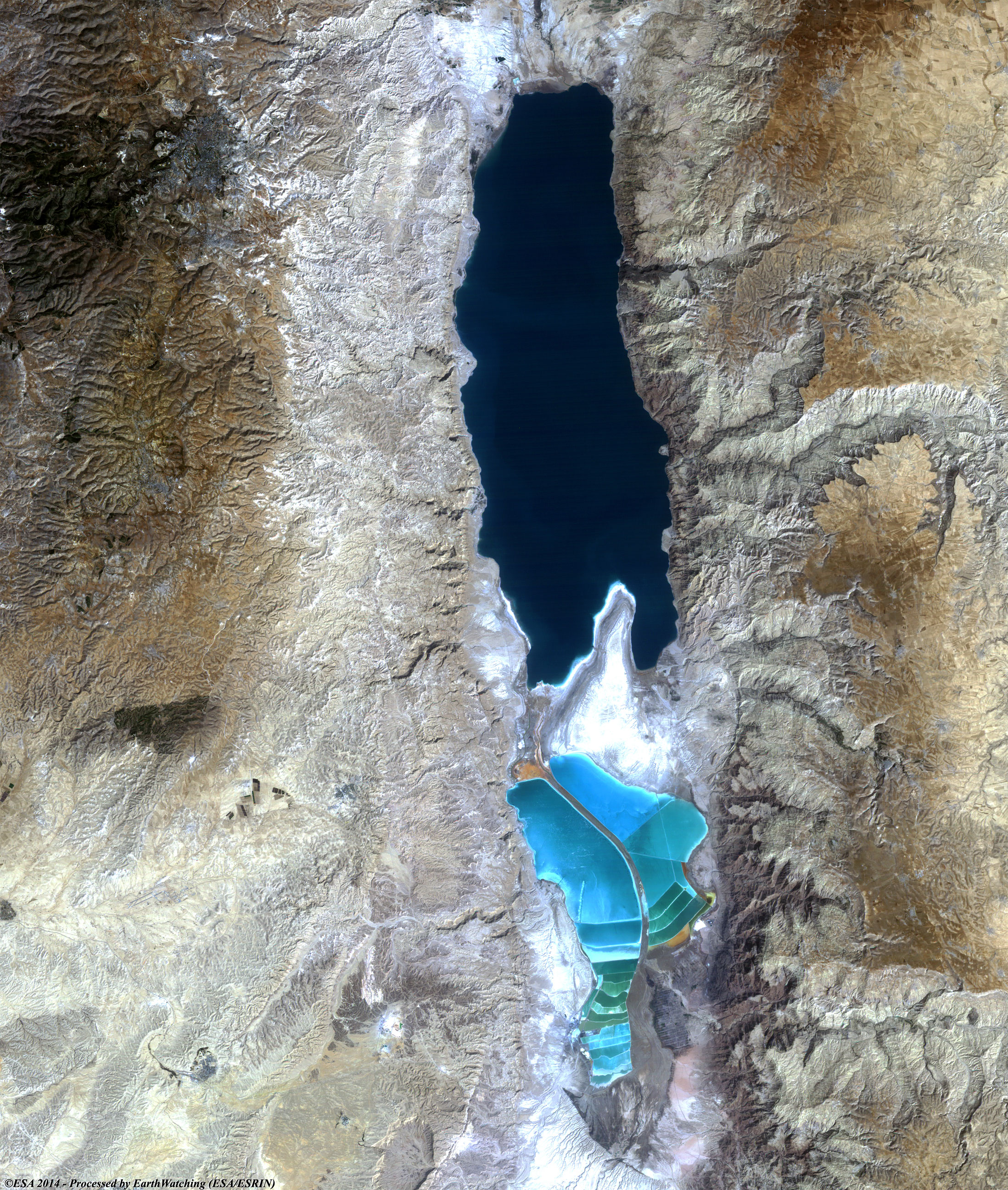
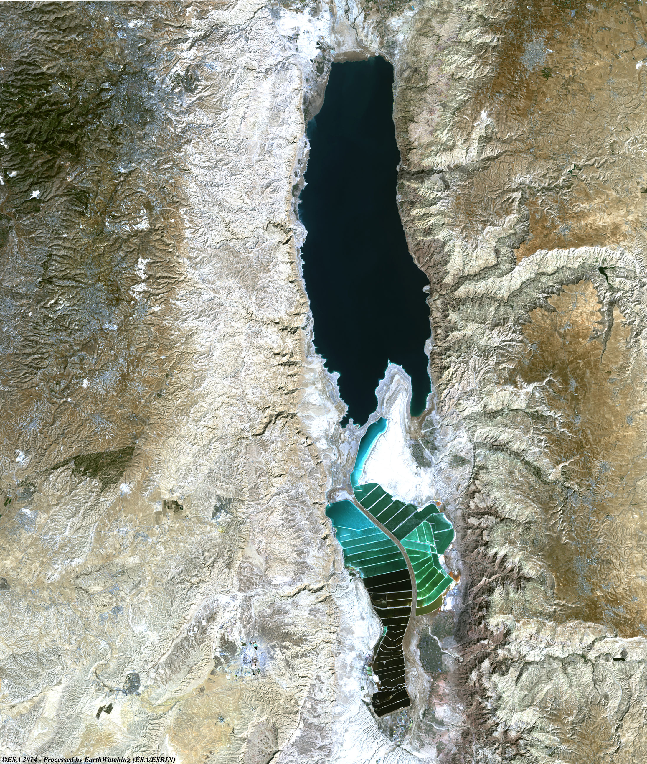
Today we feature the Dead Sea, situated between Israel and Jordan, and forming part of the border between the two countries. The Dead Sea is fed mainly by the Jordan River, which enters the lake from the north. Several smaller streams also enter the sea, chiefly from the east. The lake has no outlet, and the heavy inflow of fresh water is carried off solely by evaporation, which is rapid in the hot desert climate. Due to large-scale projects by Israel and Jordan to divert water from the Jordan River for irrigation and other water needs, the surface of the Dead Sea has been dropping dangerously for at least the past 50 years. Environmental groups, led by Friends of the Earth, launched a "Let the Dead Sea Live" campaign in 2001 to preserve the lake and its unique environmental qualities. In September 2002 Israel and Jordan agreed to construct a 320-km pipeline that would link the Dead Sea with the Gulf of Aqaba, to slow down the process of evaporation of the lake's waters. If the shrinkage is allowed to continue, it is likely that the Dead Sea might disappear altogether by 2050. These images acquired by the Landsat 5 and 8 satellites both acquired in October have a time window of acquisition (before / after) of thirty years and aim to show the difference of the coasts of the Dead Sea from 1984 until today. In fact the two images show how the lake, especially on the south coast, has suffered a significant reduction in the amount of water over the past thirty years. Another aim of these images is to promote the opportunity to download Landsat data through the ESA portals, where images captured every day are made available in near real time to the users and the scientific community. Landsat full resolution data products are freely available for immediate download at: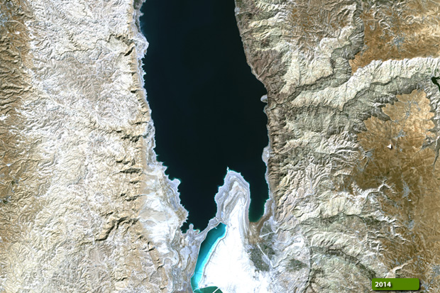 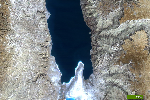 View Landsat 5 TM high resolution image (JPG 1.8 MB) View Landsat 8 OLI high resolution image (JPG 2 MB)
|
|||||||||||||||||||||