 Tehran, Iran
Tehran is the capital of Iran and Tehran Province. With a population of around 9 million in the city and 16 million in the wider metropolitan area, Tehran is the most populous city in Iran and Western Asia, and the second-largest metropolitan area in the Middle East. It is ranked 29th in the world by the population of its metropolitan area. In the Classical era, part of the present-day city of Tehran was occupied by a Median city that in the Avesta occurs as Rhaga. It was destroyed by the Mongols in the early 13th century, and remains now as a city in Tehran Province, located towards the southern end of the modern-day city of Tehran. Tehran was first chosen as the capital of Iran by Agha Mohammad Khan of the Qajar dynasty in 1796, in order to remain within close reach of Iran's territories in the Caucasus, before being separated from Iran as a result of the Russo-Persian Wars, and to avoid the vying factions of the previously ruling Iranian dynasties. The capital has been moved several times throughout history, and Tehran is the 32nd national capital of Iran. The city was the seat of the Qajars and Pahlavis, the two last imperial dynasties of Iran. It is home to many historical collections, such as the royal complexes of Golestan, Sa'dabad, and Niavaran, as well as the country's most important governmental buildings of the modern period. Large scale demolition and rebuilding began in the 1920s, and Tehran has been a destination for the mass migrations from all over Iran since the 20th century. The most famous landmarks of the city include the Azadi Tower, a memorial built during the Pahlavi period, and the Milad Tower, the world's 17th tallest freestanding structure, which was built in 2007. Tabiat Bridge, which was completed in 2014, is considered the third contemporary symbol of the city. The majority of the people of Tehran are Persian-speaking people, and roughly 99% of the population understand and speak Persian; but there are also large populations of other Iranian ethnicities in the city such as Azerbaijanis, Armenians, Lurs and Kurds who speak Persian as their second language. Tehran is served by the Mehrabad and Khomeini international airports, a central railway station, the rapid transit rail system of the Tehran Metro, as well as a trolleybus and a BRT system, and has a large network of highways. There have been plans to relocate Iran's capital from Tehran to another area; due mainly to air pollution and the city's exposure to earthquakes. To date, no definitive plans have been approved. A 2016 survey of 230 cities by consultant Mercer ranked Tehran 203rd for quality of living. According to the Global Destinations Cities Index in 2016, Tehran is among the top ten fastest growing destinations. More information is available on Wikipedia

Tehran or Teheran, capital and largest city of Iran, and capital of Tehran province, is located in the northern part of the country. Tehran is Iran's administrative, economic, and cultural centre as well as the major industrial and transport centre of the region. The city sits on the slopes of the Elburz Mountains, about 1,173m above sea level, on the northwestern fringes of the Kavir desert. Although the name Tehran means "warm place", the climate has marked seasonal contrasts, with short springs and autumns separating cold winters and hot, dry summers. Tehran is one of the largest urban centres in the Middle East. In the 1980s the metropolitan region grew rapidly, partly due to surging birthrates following the 1979 Islamic Revolution, but also because of increased migration from rural to urban areas, as well as an influx of refugees from the Iran-Iraq War and fighting in Afghanistan. The density of the inner city forced many of these migrants to settle in outlying areas. The aim of these images acquired by the Landsat family, with a time window (before/after) of 28 years, is to show how Tehran has changed since 1988. The skyline of the city has developed with new areas constructed, particularly in the north west of the city and new infrastructure; such as the area where the airport is now located in the south. Another aim of these images is to promote the opportunity to download Landsat data through the ESA portals (or third party mission free catalogue), where images captured every day are made available in near real time to the users and the scientific community. Landsat full resolution data products are freely available for immediate download at: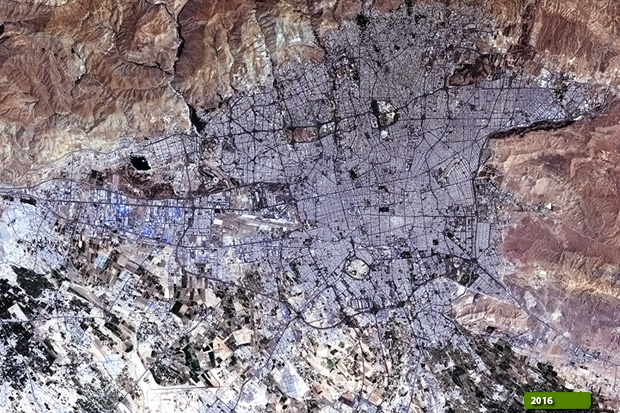 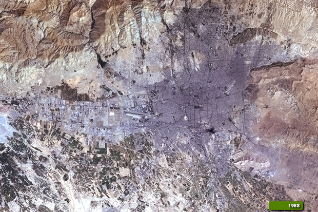 View Landsat 4 TM high resolution image (JPG 6.3 MB) View Landsat 8 OLI high resolution image (JPG 6.9 MB)
|
|||||||||||||||||||||