 Bucharest, Romania
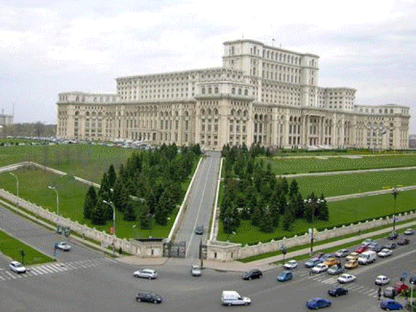
Bucharest is the capital municipality, cultural, industrial, and financial centre of Romania. It is the largest city in Romania and a primate city, located in the southeast of the country, lies on the banks of the Dâmbovi?a River, less than 70 km north of the Danube River. Bucharest was first mentioned in documents in 1459. It became the capital of Romania in 1862 and is the centre of Romanian media, culture and art. Its architecture is a mix of historical (neo-classical), interbellum (Bauhaus and art deco), communist-era and modern. In the period between the two World Wars, the city's elegant architecture and the sophistication of its elite earned Bucharest the nickname of "Little Paris". Although buildings and districts in the historic city centre were heavily damaged or destroyed by war, earthquakes, and above all Nicolae Ceauşescu's program of systematisation, many survived. In recent years, the city has been experiencing an economic and cultural boom. According to the 2011 census, 1,883,425 inhabitants live within the city limits, a decrease from the figure recorded at the 2002 census. The urban area extends beyond the limits of Bucharest proper and has a population of about 1.9 million people. Adding the satellite towns around the urban area, the proposed metropolitan area of Bucharest would have a population of 2.27 million people. According to Eurostat, Bucharest has a larger urban zone of 2,151,880 residents. According to unofficial data, the population is more than 3 million. Bucharest is the 6th largest city in the European Union by population within city limits, after London, Berlin, Madrid, Rome, and Paris. Economically, Bucharest is the most prosperous city in Romania and is one of the main industrial centres and transportation hubs of Eastern Europe. The city has big convention facilities, educational institutes, cultural venues, traditional "shopping arcades" and recreational areas. The city proper is administratively known as the "Municipality of Bucharest", and has the same administrative level as that of a national county, being further subdivided into six sectors, each governed by a local mayor. More information is available on Wikipedia
Today we feature the city of Bucharest. Situated on the banks of the Dâmboviţa River (a tributary of the Danube), approximately 64 km north of the Danube. The city lies on a generally level plain and, including suburban districts, occupies an area of about 300 sq km. Bucharest is the a major industrial centre, and accounts for one-fifth of Romania's industrial production. Industries include heavy machinery, aviation, precision machinery, agricultural tools, furniture, electronic components and equipment, chemicals, textiles, leather goods, wire, soap, cosmetics, and processed food. Bucharest is also the financial and trade centre of Romania. These images acquired by the Landsat 5 and 8 satellites have a time window of acquisition (before / after) of thirty years and aim to show the urban difference from 1984 until today. In fact the two images show how the areas around the city have experienced large urban development during this period. Another aim of these images is to promote the opportunity to download Landsat data through the ESA portals, where images captured every day are made available in near real time to the users and the scientific community. Landsat full resolution data products are freely available for immediate download at: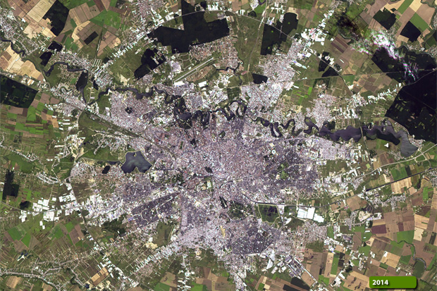 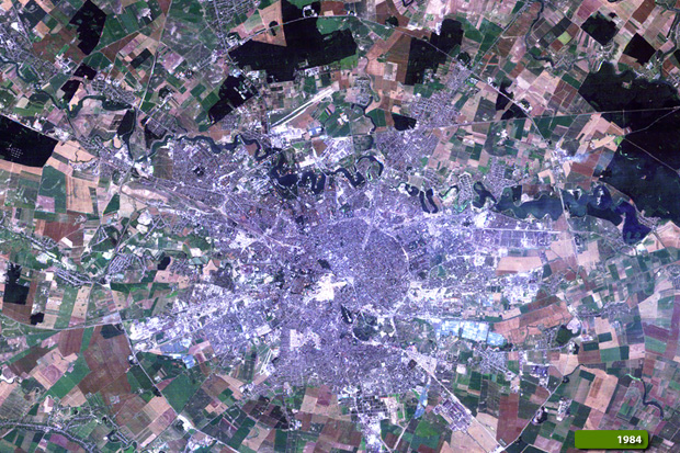 View Landsat 5 TM high resolution image (JPG 1.5 MB) View Landsat 8 OLI high resolution image (JPG 1.6 MB)
|
|||||||||||||||||||||