- All Categories (116)
- News (9)
- Missions (19)
- Events (9)
- Activities (2)
- Documents (77)
MISSIONS
Explore the European Space Agency's Earth Observation satellite missions. Learn all about ESA's dedicated Earth Explorers or collaborations with other agencies through the Third Party Missions programme.
Mission - Earth Explorers

GOCE
Explorer (GOCE) mission mapped Earth's geoid very accurately, opening a window into Earth's interior structure as well as the currents
Mission - Heritage Missions

SAR (ERS) Processor Releases
It should be noted that for SAR, each product ordered is processed directly from the raw data, using the current version
Mission - Heritage Missions

PALSAR
A small percentage of ALOS-1 PALSAR products processed by the current installed ESA IPF are affected by a known quality issue
Mission - Heritage Missions

PALSAR Processor Releases
The current ALOS-1 PALSAR IPF integrated within the ESA On-The-Fly system is v4.16p9, installed on 24 January 2017.
Mission - Earth Explorers
GOCE Objectives
Thanks to this current, the coastal waters of Europe are 4°C warmer than waters at equivalent latitudes in the north Pacific
Mission - Heritage Missions
SAR (ERS)
Processor Releases It should be noted that for SAR, each product ordered is processed directly from the raw data, using the current
Mission - Earth Explorers
EGG
This opened a window into Earth's interior structure, as well as the currents circulating within the depths of its oceans
Mission - Heritage Missions

ERS Radar Course 1
Therefore, microwaves easily penetrate clouds, and images can be acquired independently of the current weather conditions
Mission - Earth Explorers
SSTI ANTEX Data
data were generated from 154 days in 2009 GOCE SSTI-B PCVs data were generated from the available data in 2010-2012 The current
Mission - Heritage Missions
GOCE re-entry dataset
with further dynamical and environmental information such as on-board magnetometer measurements of Earth's magnetic field, currents
Mission - Heritage Missions
PALSAR Quality Control Reports
Find out more Quality Disclaimer A small percentage of ALOS-1 PALSAR products processed by the current installed ESA IPF
Mission - Earth Explorers
GOCE Overview
height mapped by altimeters and the knowledge of the precise ocean geoid that has improved our understanding of surface currents
Mission - Third Party Missions

ALOS-1 Mission Objectives
Oceanography and coastal zone-related research (oil spill, high-resolution DEM) Coastal zones, sea surface wind, wave height, wave current
Mission - Heritage Missions
PALSAR Products Information
The service currently provides access from ESA's archive to the following PALSAR L1 high-resolution data products.
Mission - Heritage Missions
SAR (ERS) Interferometry
addition, components of the interferometric signal such as anomalous signal path lengths introduced by atmospheric effects are currently
Mission - Heritage Missions
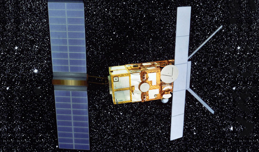
SAR (ERS) Overview
Scientists are studying the radar backscatter from the ocean surface related to wind and current fronts, to eddies and to
Mission - Heritage Missions
ERS Radar Course 2
Therefore, microwaves easily penetrate clouds, and images can be acquired independently of the current weather conditions
Mission - Heritage Missions
ERS Radar Course 3
Therefore, microwaves easily penetrate clouds, and images can be acquired independently of the current weather conditions
Mission - Heritage Missions

ERS Overview
global scale, the two ERS satellites expanded our understanding of the interaction between the oceans and atmosphere, ocean currents