- All Categories (25)
- News (9)
- Missions (2)
- Events (2)
- Tools (1)
- Activities (3)
- Documents (8)
News - Events and Proceedings
Φ-Week Triumphs
Opening Session Title: Φ-Week's Opening Session Description: During the fourth edition of ESA’s Φ -Week, Josef Aschbacher, current
Event - Meeting
VH-RODA and CEOS SAR workshop
The workshop provided an open forum for the presentation and discussion of current status and future developments related
News - Success Stories
TPM data help advance plastic litter detection from space
detection and tracking of large marine litter based on high-resolution remote sensing time series, machine learning, and ocean current
Document - General Reference
Third Party Missions Brochure
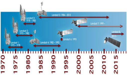
This brochure summarises ESA's Third Party Missions programme, providing a timeline and examples of content related to some of the missions.
Mission - Third Party Missions
Thematic Mapper (TM) Processor Releases
GCP displacement B TM radiometric calibration Update to radiometric calibration strategy for TM reflective bands (Dark Current
Document - Technical Note
Technical Note on Quality Assessment for Landsat 1-7
Technical Note on Quality Assessment for Landsat 1-7
News - Success Stories
Space data unearths small-scale mining in Burkina Faso
Burkina Faso is currently the fastest-growing and fifth-largest gold producer in Africa, with ASM providing a livelihood
Activity - Quality
SLAP
Currently, in excess of 701,000 Level 1 TM and 84,000 Level 1 ETM+ products have been reprocessed and released under the
News - Thematic area articles
Satellite data central to ocean monitoring
microwave monitoring instruments, optical imagers, and infrared radiometers, which can map ocean variables related to ocean currents
News - Success Stories
Pléiades unlocks information about rock glaciers in central Himalaya
says lead researcher, Tobias Bolch, at the School of Geography and Sustainable Development, University of St Andrews, UK, currently
Mission - Third Party Missions
Multi Spectral Scanner (MSS) Processor Releases
GCP displacement B TM radiometric calibration Update to radiometric calibration strategy for TM reflective bands (Dark Current
News - Success Stories
Monitoring the health of wheat crops from space
“In the current research, we aimed to detect more subtle signs of disease that manifest in earlier growth stages, giving
Document - Product Document
LANDSAT_Products_Description_Document.pdf
This document acts as a User Guide to the Landsat MSS, TM and ETM+ archives, focussing more specifically on the Landsat TM and ETM+ products from the Kiruna, Maspalomas and Matera archives (including from the Matera, Fucino, Neustralitz, O’Higgins, Malindi, Libreville and Bishkek ground stations) that have been generated as part of the ESA archive bulk-reprocessing project.
News - Thematic area articles
How to use space data to probe humankind’s ancient past
SkySat captures Angkor Wat in Cambodia TPMs that are currently providing high resolution or very high resolution imagery
News - Thematic area articles
How satellite data empower sustainable urban growth
Some 56% of the world's population currently reside in cities and the number of urban inhabitants is expected to double by
Document - General Reference
Heritage Missions brochure
This brochure describes ESA's Heritage Space Programme and includes infographics describing some of the missions in the programme.
News - Success Stories
Heritage data trains neural networks to detect urban sprawl
Since they’ve been trained identically, they can help monitor both current and past urban changes.
Tools - Visualisation
HEDAVI
ESA’s Heritage EO data currently cover more than 30 years of observations and enable the analysis of spatio-temporal dynamics
Activity - General activities
GSCB and LTDP
Envisat data are used in many fields of Earth science, including atmospheric pollution, fire extent, sea ice motion, ocean currents


