- All Categories (354)
- News (6)
- Missions (10)
- Events (8)
- Documents (330)
Mission - Earth Explorers

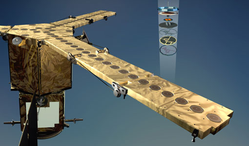
GOCE
Explorer (GOCE) mission mapped Earth's geoid very accurately, opening a window into Earth's interior structure as well as the currents
Event - Workshop

IDEAS+ Cal/Val Workshop 7
Regular workshops are held every nine months with the whole IDEAS+ Task 3-Cal/Val team in order to review the status of current
Mission - Earth Explorers
SMOS product availability
+ NIR + Long LO + FTT LO + Electrical Stability LO + NIR + Long + FTT LO + Short LO + Long + Short Current
News - General News
ESA's excellent Earth Explorer missions extended to 2025
Acting like the spinning conductor in a bicycle dynamo, it generates electrical currents and thus the continuously changing
Event - Training

EO Summer School 4
Keynote lectures on global change issues are also given to discuss the current state of the science of global change and
Mission - Earth Explorers
GOCE Objectives
Thanks to this current, the coastal waters of Europe are 4°C warmer than waters at equivalent latitudes in the north Pacific
Mission - Earth Explorers

SMOS Objectives
SMOS Science The SMOS mission is a direct response to the current lack of global observations of soil moisture and ocean
Event - Training
EO Summer School 3
In line with observations it shows anti-cyclonically rotating surface currents and cyclonically rotating bottom currents.
Event - Training
EO Summer School 5
Keynote lectures on global change issues are also given to discuss the current state of the science of global change and
News - Data Release news
New version of the SMOS-CryoSat level 4 sea ice thickness product is now available
The current version 205 replaces the previous baseline version 204.
Mission - Earth Explorers
EGG
This opened a window into Earth's interior structure, as well as the currents circulating within the depths of its oceans
News - Thematic area articles

Satellite data central to ocean monitoring
microwave monitoring instruments, optical imagers, and infrared radiometers, which can map ocean variables related to ocean currents
Mission - Earth Explorers
SSTI ANTEX Data
data were generated from 154 days in 2009 GOCE SSTI-B PCVs data were generated from the available data in 2010-2012 The current
Mission - Earth Explorers
Products Information
For an optimal exploitation of the current SMOS L2 data set V620 consult the read-me-first notes available for V620 soil
Event - Workshop
Understanding the Carbon and Water Cycles using SMOS Data and Models
main land interactions and their impacts on the Earth system and climate by exploiting SMOS observations; To review the current
Document - General Reference

The Nine Candidate Earth Explorer Missions - Topography Mission
This report for assessment addresses the Topography mission when it was selected with other nine Earth Explorer missions as a potential candidate for Phase A study.
Document - Proceedings

EO-Summer-School-6-ESA-explorer-mission-GOCE-earth-gravity-from-space.pdf
This presentation from ESA's EO Summer School 6 presents the ESA explorer mission GOCE earth gravity from space
Mission - Heritage Missions
GOCE re-entry dataset
with further dynamical and environmental information such as on-board magnetometer measurements of Earth's magnetic field, currents
Mission - Earth Explorers
SMOS Overview
Mission Background The SMOS mission is a direct response to the current lack of global observations of soil moisture and
Mission - Earth Explorers
GOCE Overview
height mapped by altimeters and the knowledge of the precise ocean geoid that has improved our understanding of surface currents