- All Categories (37)
- News (5)
- Missions (8)
- Events (4)
- Activities (2)
- Campaigns (2)
- Documents (16)
Mission - Earth Explorers

GOCE
Explorer (GOCE) mission mapped Earth's geoid very accurately, opening a window into Earth's interior structure as well as the currents
Activity - Quality

EDAP
The following missions are currently being considered as part of the Automatic Identification System (AIS) and Radio Frequency
News - General News
ESA's excellent Earth Explorer missions extended to 2025
Acting like the spinning conductor in a bicycle dynamo, it generates electrical currents and thus the continuously changing
Activity - Quality
SLAP
Currently, in excess of 701,000 Level 1 TM and 84,000 Level 1 ETM+ products have been reprocessed and released under the
Mission - Earth Explorers
GOCE Objectives
Thanks to this current, the coastal waters of Europe are 4°C warmer than waters at equivalent latitudes in the north Pacific
Document - General Reference

The Earth Observation Handbook, 2010 Update - Key Tables
This is the 2010 update of the CEOS Earth Observation Handbook. You can browse the live database at http://database.eohandbook.com/ or download the printable PDF of key tables based on the 2010 database contents for a handy reference.
Event - Workshop

IDEAS-QA4EO Cal/Val Workshop #2
Format - Virtual meeting (Webex), reports from all IDEAS-QA4EO members + discussion session Goal - Reviewing current status
Document - General Reference
Introduction-CryoSat-2-ICESat-2-Resonant-Orbits.pdf
This presentation describes the CRYO2ICE campaign.
Mission - Earth Explorers
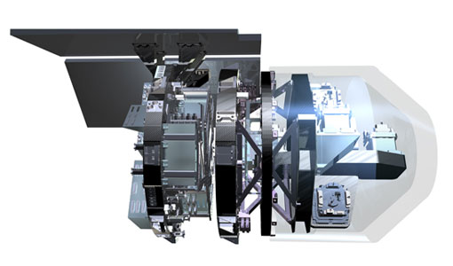
EGG
This opened a window into Earth's interior structure, as well as the currents circulating within the depths of its oceans
Document - Technical Note

Guidelines-for-the-SAR-Delay-Doppler-L1b-Processing.pdf
The purpose of this document is to present the major theoretical guidelines for a standard SAR (aka Delay Doppler) Processing from low-level data (FBR, aka L1a) to multi-looked waveforms (L1b) in case of the Closed-Burst instrument transmission mode (CryoSat-2 and Sentinel-3 case).
Mission - Earth Explorers
SSTI ANTEX Data
data were generated from 154 days in 2009 GOCE SSTI-B PCVs data were generated from the available data in 2010-2012 The current
Document - Proceedings

Dragon Programme Mid-Term Results
Proceedings of the 2005 Dragon Symposium held on 27 June - 1 July 2005 in Santorini, Greece.
Document - Proceedings
EO-Summer-School-6-ESA-explorer-mission-GOCE-earth-gravity-from-space.pdf
This presentation from ESA's EO Summer School 6 presents the ESA explorer mission GOCE earth gravity from space
Document - General Reference
BIOMASS-Report-for-Mission-Selection-An-Earth-Explorer-to-observe-forest-biomass.pdf
The objective of the BIOMASS Mission is to determine the global distribution of forest biomass by reducing the uncertainty in the calculation of carbon stock and fluxes associated with the terrestrial biosphere.
Document - General Reference
SMOS-ESAs-Water-Mission-Fact-sheet.pdf
This document provided a series of information on the SMOS mission.
Mission - Heritage Missions
GOCE re-entry dataset
with further dynamical and environmental information such as on-board magnetometer measurements of Earth's magnetic field, currents
Document - General Reference
SPECTRA-Surface-Processes-and-Ecosystem-Changes-Through-Response-Analysis.pdf
This report describes the SPECTRA mission, one of the candidate Earth Explorers in the second cycle in 2001.
News - Data Release news
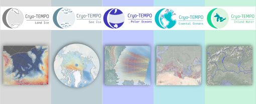
New CryoSat-2 Thematic Products Now Available
The current product release represents the culmination of Phase 1 of the Cryo-TEMPO activities, which began in October 2020
Mission - Earth Explorers
GOCE Overview
height mapped by altimeters and the knowledge of the precise ocean geoid that has improved our understanding of surface currents
Campaign
CryoVEx ICESat-2 Summer 2019
The CReSIS radar is a classic nadir-looking altimeter, i.e. the current system configuration does not support acquisition