- All Categories (76)
- News (5)
- Missions (6)
- Events (3)
- Tools (2)
- Documents (60)
Mission - Earth Explorers

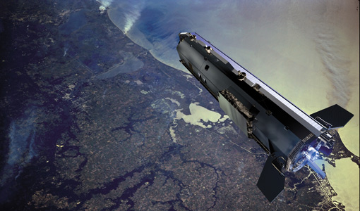
GOCE
Explorer (GOCE) mission mapped Earth's geoid very accurately, opening a window into Earth's interior structure as well as the currents
Document - General Reference

Earth-Explorers-Satellites-to-understand-our-changing-Earth.pdf
This eight-page brochure provides an overview of the Earth Explorers currently in orbit and those under development.
Tools - Analysis

GOCE User Toolbox
Data output formats The current data formats that GUT can provide in output are: netCDF (Climate and Forecast Metadata Convention
News - Data Release news

GOCE EGG L1b reprocessed data published
The GOCE L2 data, including the gravity field models, are currently being regenerated and will be available in Q2 2019.
Mission - Earth Explorers
GOCE Objectives
Thanks to this current, the coastal waters of Europe are 4°C warmer than waters at equivalent latitudes in the north Pacific
Document - General Reference
GOCE-Obtaining-a-Portrait-of-Earths-Most-Intimate-Features.pdf
This is an article extracted from the ESA Bulletin Nr. 133.
Document - Proceedings

4th-International-GOCE-User-Workshop.pdf
Proceedings of the 4th International GOCE User Workshop held on 31 March - 1 April 2011 at the Technische Universitat Munich, Germany
Document - Software Verification Plan/Report

GUTS-Promo-Leaflet.pdf
This leaflet summarizes the results of the GOCE User ToolboxSpecifications Study (GUTS).
Document - General Reference
Meteosat-Second-Generation-New-Horizons-for-Weather-and-Climate.pdf
This brochure gives a general overview on the mission and its application.
Document - General Reference
The MSG System - consisting of a Space Segment and a Ground Segment, designed to provide data, based on a series of three satellites called MSG-1, -2 and -3
This article was published in the ESA Bulletin Nr. 111.
Document - General Reference
Earth-Explorers.pdf
This flyer gives a quick overview of the 6 Earth Explorers missions.
Document - General Reference
The Nine Candidate Earth Explorer Missions - Gravity Field and Steady-State Ocean Circulation Mission
This report for assessment addresses the Earth Explorer Gravity Field and Steady-State Ocean Circulation (GOCE) mission at the time when it was selected with other 9 Earth Explorer missions as potential candidate for Phase A study.
Document - General Reference
The In-Orbit Commissioning of MSG-1
This article was published in the ESA Bulletin Nr. 114.
Document - Proceedings
2nd-MSG-RAO-Workshop.pdf
Proceedings of the 2nd MSG RAO Workshop, held on 9-10 September 2004 in Salzburg, Austria
Document - Software Verification Plan/Report
GUT-Tutorial.pdf
The objective of the GUT tutorial, together with the GUT Algorithm Description and User Guide (RD3), is to assist you in getting acquainted with the GOCE User Toolbox, whose objective is to help you take major benefit from the GOCE data for your own application.
Tools - Analysis
GOCEXML2ASCII
GOCEXML2ASCII is a command-line tool, currently running on Linux. A port to Mac is under evaluation.
Mission - Earth Explorers
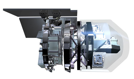
EGG
This opened a window into Earth's interior structure, as well as the currents circulating within the depths of its oceans
Document - General Reference
The Four Candidate Earth Explorer Core Missions - GOCE
The Living Planet Programme document (ESA SP-1227, available to be ordered on this Library in the General Information section) describes the plans for the Agency's new strategy for Earth Observation in the post-2000 time frame. Out of the nine Earth Explorer Core Missions identified in 1996, four Core Missions were selected for Phase-A studies, which began in 1998. In particular this is volume 1 describing in detail the Gravity Field and Steady-State Ocean Circulation Mission.
Document - General Reference
GOCE-ESAs-Gravity-Mission.pdf
This brochure describes the science behind the GOCE mission and how the satellite works.
News - Thematic area articles

Satellite data central to ocean monitoring
microwave monitoring instruments, optical imagers, and infrared radiometers, which can map ocean variables related to ocean currents