- All Categories (31)
- News (7)
- Missions (8)
- Events (2)
- Activities (2)
- Campaigns (1)
- Documents (11)
Activity - Quality
SCIRoCCo
Author: The SCIRoCCo Team Abstract: The ERS Scatterometers in the Global Climate Observing System report describes the current
News - Thematic area articles

How satellite data help to shape society
Title: Current drought situation in Ebro basin Description: The SMOS soil-moisture-based drought monitor is updated monthly
News - General News
ESA's excellent Earth Explorer missions extended to 2025
Acting like the spinning conductor in a bicycle dynamo, it generates electrical currents and thus the continuously changing
Mission - Heritage Missions

SAR (ERS) Processor Releases
It should be noted that for SAR, each product ordered is processed directly from the raw data, using the current version
Event - Training

EO Summer School 4
Keynote lectures on global change issues are also given to discuss the current state of the science of global change and
Document - General Reference

The Earth Observation Handbook, 2010 Update - Key Tables
This is the 2010 update of the CEOS Earth Observation Handbook. You can browse the live database at http://database.eohandbook.com/ or download the printable PDF of key tables based on the 2010 database contents for a handy reference.
Document - General Reference
Introduction-CryoSat-2-ICESat-2-Resonant-Orbits.pdf
This presentation describes the CRYO2ICE campaign.
Mission - Heritage Missions
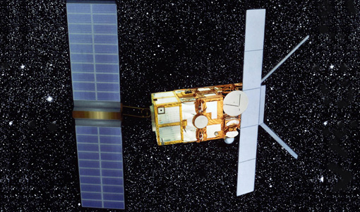
SAR (ERS)
Processor Releases It should be noted that for SAR, each product ordered is processed directly from the raw data, using the current
Document - Technical Note

Guidelines-for-the-SAR-Delay-Doppler-L1b-Processing.pdf
The purpose of this document is to present the major theoretical guidelines for a standard SAR (aka Delay Doppler) Processing from low-level data (FBR, aka L1a) to multi-looked waveforms (L1b) in case of the Closed-Burst instrument transmission mode (CryoSat-2 and Sentinel-3 case).
Mission - Heritage Missions

ERS Radar Course 1
Therefore, microwaves easily penetrate clouds, and images can be acquired independently of the current weather conditions
Document - Proceedings

Dragon Programme Mid-Term Results
Proceedings of the 2005 Dragon Symposium held on 27 June - 1 July 2005 in Santorini, Greece.
Document - General Reference
BIOMASS-Report-for-Mission-Selection-An-Earth-Explorer-to-observe-forest-biomass.pdf
The objective of the BIOMASS Mission is to determine the global distribution of forest biomass by reducing the uncertainty in the calculation of carbon stock and fluxes associated with the terrestrial biosphere.
Document - General Reference
SMOS-ESAs-Water-Mission-Fact-sheet.pdf
This document provided a series of information on the SMOS mission.
Document - General Reference
SPECTRA-Surface-Processes-and-Ecosystem-Changes-Through-Response-Analysis.pdf
This report describes the SPECTRA mission, one of the candidate Earth Explorers in the second cycle in 2001.
News - Data Release news
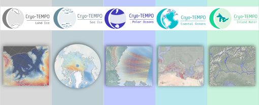
New CryoSat-2 Thematic Products Now Available
The current product release represents the culmination of Phase 1 of the Cryo-TEMPO activities, which began in October 2020
Campaign

CryoVEx ICESat-2 Summer 2019
The CReSIS radar is a classic nadir-looking altimeter, i.e. the current system configuration does not support acquisition
Document - General Reference
The four Candidate Earth Explorer Core Missions - Land-Surface Processes and Interactions Mission
This report describes the Land-Surface Processes and Interactions Mission, one of the four Candidate Earth Explorers in 1999.
Document - General Reference
The Nine Candidate Earth Explorer Missions - Land-Surface Processes and Interactions Mission
This report for assessment addresses the Land-Surface Processes and Interactions mission when it was selected with other nine Earth Explorer missions as a potential candidate for Phase A study.
Document - General Reference
Healing-the-Earth-Earth-Observation-Supporting-International-Environmental Conventions.pdf
This article is extracted from ESA Bulletin Nr. 128.
News - Success Stories

Heritage data trains neural networks to detect urban sprawl
Since they’ve been trained identically, they can help monitor both current and past urban changes.