- All Categories (77)
- Data (4)
- News (26)
- Missions (2)
- Events (11)
- Tools (5)
- Activities (2)
- Documents (27)
NEWS
Discover the latest news on the European Space Agency's Earth Observation activities. Learn all about new data availability and how ESA's missions are performing.
News - Infographics
19 Mar 2024Explore sample data products from Third Party Missions
ESA’s Third Party Missions programme consists of over 50 satellite missions from commercial and public organisations worldwide.
News - General News
27 Feb 2024Go-to guide to Third Party Mission data offering
ESA’s latest Third Party Missions Data Access Guide has been published, providing technical details and information on available data collections for all current or past Third Party Missions.
News - Data Release news
13 Feb 2024Sample data products from ESA’s Third Party Missions
Samples of data products from a range of Third Party Missions are now available to download, offering a preview of what these missions provide.
News - Thematic area articles
7 Dec 2023How to use space data to probe humankind’s ancient past
Data disseminated by ESA’s Third Party Missions (TPM) programme are enabling archaeological investigations that could help to unravel the mysteries of past societies and cultures.
News - Success Stories
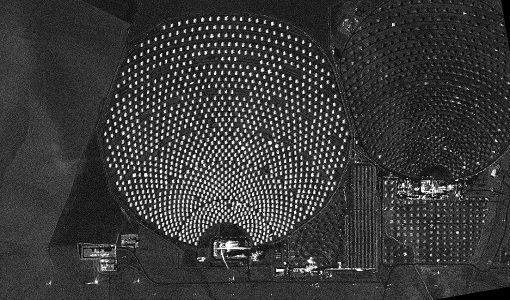
17 Aug 2023Commercial and international data for fire monitoring
As climate change sparks a surge in the frequency and intensity of wildfires, satellite data disseminated through ESA’s Third Party Missions (TPM) programme are helping scientists to track and investigate these potentially damaging natural events.
News - Infographics
22 Feb 2023Twin satellites - TerraSAR-X and TanDEM-X
DLR's TerraSAR-X and TanDEM-X are twin satellites flying in close formation to acquire SAR data of unique geometric accuracy. Operating together, the missions deliver data that are used to generate Digital Elevation Models of Earth.
News - General News
16 Feb 2023International collaboration: Summarising ESA’s Third Party Missions
ESA’s Third Party Missions programme consists of more than 50 missions from around the world. Learn more about the Third Party Missions in this video.
News - Success Stories
30 Jan 2023Showcasing success stories from ESA's Third Party Missions
ESA’s Third Party Missions programme consists of more than 50 missions from around the world.
News - Data Release news
 6 Oct 2022
PAZ ESA archive now open to users
The PAZ ESA archive collection is now freely available for researchers worldwide through ESA's Third Party Missions programme.
News - Thematic area articles
 29 Sept 2022
How satellite data help to shape society
Data from ESA’s Earth observation archives are improving understanding of the interactions between human activities and the environment, helping to power green economic development and boosting prosperity in Europe and beyond.
News - Success Stories
 25 Aug 2022
Tracking mountainous glaciers using TanDEM-X
Ice melting from mountain glaciers is one of the largest contributors to sea-level rise outside the large ice sheets of Antarctica and Greenland. New research leveraging the vast data from the TanDEM-X mission, has successfully mapped glacial elevation change over multiple mountainous regions of the world.
News - Events and Proceedings
 25 May 2022
National missions in the spotlight at the Living Planet Symposium
In the framework of ESA’s Third Party Missions (TPM) programme, the agency offers access to the full data archives of almost 50 satellite missions, which are owned by organisations around the world.
News - Thematic area articles
 18 May 2022
How ESA uses space data to explore deep Earth
As anthropogenic activities continue to unbalance our environment, scientists strive to fully understand the intricate interactions within Earth’s system.
News - Success Stories
 17 Mar 2022
New open-source Python library improves rapid mapping services
In emergency services, rapid response is paramount. ICube-SERTIT’s Rapid Mapping Service provides near real-time delivery of geo-information to help emergency services respond quickly to disasters such as flooding, fires and landslides. A new Python open-source library, called EOReader, speeds up this mapping response by enabling the easy opening of imagery from multiple satellite sensors, both optical and synthetic aperture radar (SAR).
News - Success Stories
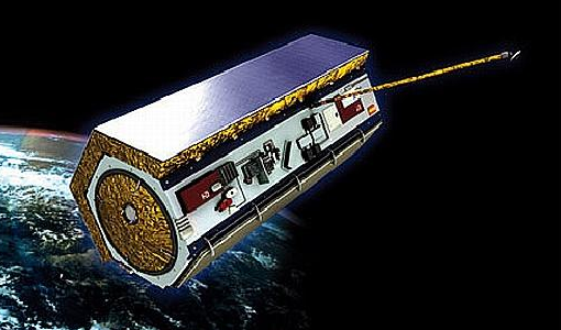
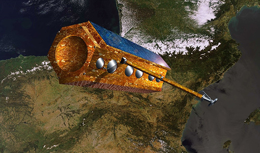 17 Feb 2022
PAZ - Spain's radar success
One way of collecting images in unfavourable weather is to use Synthetic Aperture Radar (SAR). PAZ is one such Earth observation mission capable of delivering all-weather imagery thanks to its X-band SAR.
News - Infographics
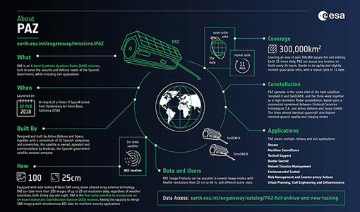 15 Feb 2022
An overview of the PAZ SAR satellite mission
Learn more about the PAZ mission, a Spanish X-Band SAR satellite and part of ESA's Third Party Missions programme, in our latest infographic.
News - Data Release news
 18 Jan 2022
New imaging modes added to PAZ collection
Two new imaging modes, Wide ScanSAR and Staring Spotlight, have been added to the PAZ offering and are now available to users for research and application development following submission of a project proposal subject to evaluation and acceptance by ESA and the data owner.
News - Data Release news
 7 Dec 2021
TerraSAR-X/TanDEM-X WorldDEM data now available to users
WorldDEM products have been added to the TerraSAR-X/TanDEM-X offering and are now available to users for research and application development following submission of a project proposal subject to evaluation and acceptance by ESA and the data owner.
News - Infographics
 8 Nov 2021
An overview of ESA's Third Party Missions programme
ESA’s Third Party Missions programme consists of almost 50 satellite missions, which are owned by organisations around the world. ESA has agreements with these organisations to acquire, process, and distribute data from their missions
News - Success Stories
 8 Oct 2021
Earth Observation data to improve navigation risk modelling and shipping routes
With the increased frequency of shipping activities, such as tourism and transport of freights, navigation safety has become a major concern. Even if new technologies have already supplied aids to pilots for navigation risk reduction, the International Maritime Organisation (IMO) reports that the majority of accidents could have been avoided by providing suitable input to the navigation decision-making process — this is where Earth Observation data can represent complementary information, to improve traffic monitoring and guidance along safe routes.