- All Categories (241)
- News (24)
- Missions (1)
- Events (16)
- Tools (1)
- Activities (5)
- Campaigns (13)
- Documents (181)
NEWS
Discover the latest news on the European Space Agency's Earth Observation activities. Learn all about new data availability and how ESA's missions are performing.
News - Data Release news
 5 Mar 2018
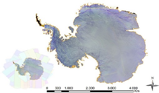
PROBA-V data available over Antarctica
Due to a huge amount of interest, it was decided to acquire PROBA-V data over Antarctica from November 2017 to February 2018.
News - Data Release news
 7 Mar 2019
PROBA-V 2018-2019 Antarctica data now available
For the second consecutive austral summer season, PROBA-V observed Antarctica and its ongoing changes.
News - Operational News
 15 May 2019
PROBA-V global land cover maps released
Copernicus Global Land Service team have released their new set of global land cover layers for the year 2015.
News - Infographics
21 Apr 2020PROBA-V - ESA's vegetation monitoring mission
ESA's vegetation-monitoring mission - Proba-V - will end operations in June 2020 after seven years.
News - Success Stories
 30 Apr 2020
Mission continuity
Long-term availability of Earth observation data from a given instrument is crucial to many data users and their research—but just how does it work?
News - Operational News
 10 Aug 2020
New experimental phase for PROBA-V
PROBA-V has begun a new experimental phase that will continue through to October 2021.
News - Data Release news
 15 Dec 2020
New Campaign datasets available
A new set of datasets is available, acquired during airborne campaigns conducted between 2014 and 2019
News - Success Stories
 25 Nov 2021
COP26 fuels interest in satellite data
As COP26 stimulates action to reduce global warming, the essential role of satellite data in understanding and monitoring climate change is apparent.
News - Data Release news
 27 Jan 2022
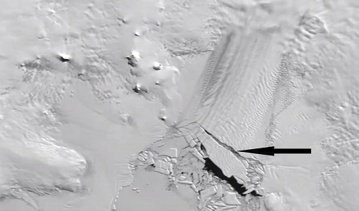
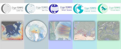
New CryoSat-2 Thematic Products Now Available
As of January 2022, ESA has started releasing new CryoSat-2 Thematic Products, dedicated to five distinct areas: Sea Ice, Land Ice, Polar Oceans, Coastal Oceans and Inland Waters.
News - Thematic area articles
 2 Feb 2022
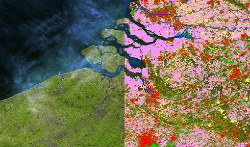
Satellite data boost global understanding of land surface
Understanding our changing land surface is essential in the study of climate change. Satellites are used to monitor changes to the material that covers Earth’s surface, so-called land cover, such as vegetation and water.
News - Thematic area articles
 30 June 2022
Transforming space data into climate action
ESA’s Earth observation activities are playing a key role in the revitalised global drive to combat climate change.
News - General News
14 July 2022Campaign using surface reflectance data to support validation of Earth observation products
Scientists from around the world are set to take part in a drone monitoring campaign and inter-comparison exercise that will deliver surface reflectance data to support the validation of Earth observation products.
News - Thematic area articles
9 Dec 2022Global understanding of Earth's land surfaces greatly boosted by satellite data
ESA perform land surface monitoring with a range of instruments onboard satellites acquiring optical and radar data. Collections of data from these missions are freely available for research purposes.
News - Thematic area articles
3 Mar 2023Monitoring water on Earth's surface
ESA's Earth observation satellites are playing a leading role in furthering our understanding of how Earth's terrestrial hydrosphere is being influenced by humankind.
News - General News
21 Mar 2023ESA's excellent Earth Explorer missions extended to 2025
Since 2009, ESA’s Earth Explorer missions have pioneered breakthrough technologies and transformed our understanding of Earth’s system, from its core to the outer stretches of the atmosphere.
News - Data Release news
11 Apr 2023PROBA-V ‘Collection 2’ - Reprocessed Dataset available
The improved PROBA-V data (Collection 2) has been released. Data is available via the PROBA-V MEP and Terrascope platforms so users can freely exploit the data using Virtual machines, Jupyter Notebooks, and the new viewing application.
News - Events and Proceedings
21 Apr 2023Scientists to showcase value of Earth observation data at EGU
Remote sensing scientists are getting ready to present innovative and exciting applications of satellite data at the European Geosciences Union general assembly which will take place from 24 to 28 April in Vienna, Austria.
News - Thematic area articles
25 Apr 2023Remote sensing data map impacts of natural hazards
As climate change increases the frequency and severity of natural disasters, remote sensing data can warn about extreme events and help tackle emergency situations.
News - Success Stories
8 May 2023PROBA-V data improve surface albedo products in Africa
As ESA’s PROBA-V satellite marks its 10-year launch milestone, data tasked during the mission’s lifetime are still being used to assess changes in land cover.
News - Spotlight on EO community
13 June 2023Meet one of ESA's first Africa Programme Research Fellows
Research Fellow, Dr Gladys Mosomtai, from the International Centre of Insect Physiology and Ecology (icipe), works on applying Earth observation data to better understand the spread of infectious disease in livestock, in Kenya.