- All Categories (16971)
- Data (19)
- News (42)
- Missions (2)
- Events (37)
- Tools (6)
- Activities (10)
- Campaigns (2)
- Documents (16853)
NEWS
Discover the latest news on the European Space Agency's Earth Observation activities. Learn all about new data availability and how ESA's missions are performing.
News - Data Release news
 5 Mar 2018
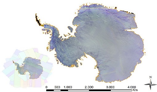
PROBA-V data available over Antarctica
Due to a huge amount of interest, it was decided to acquire PROBA-V data over Antarctica from November 2017 to February 2018.
News - Operational News
 4 Jan 2019
Envisat-ERS (A)SAR - Enhanced Dissemination Service
ESA is pleased to announce the release of several new features as part of the ESA On-The-Fly data processing and dissemination service.
News - Data Release news
 7 Mar 2019
PROBA-V 2018-2019 Antarctica data now available
For the second consecutive austral summer season, PROBA-V observed Antarctica and its ongoing changes.
News - Operational News
 15 May 2019
PROBA-V global land cover maps released
Copernicus Global Land Service team have released their new set of global land cover layers for the year 2015.
News - Data Release news
 12 July 2019
Updated Precise Orbit data (POD) for the full ERS-1 and ERS-2 mission available
The Precise Orbit files (ERS.ORB.POD) for the entire ERS-1 and ERS-2 mission periods have been reprocessed with up-to-date standards.
News - Infographics
21 Apr 2020PROBA-V - ESA's vegetation monitoring mission
ESA's vegetation-monitoring mission - Proba-V - will end operations in June 2020 after seven years.
News - Success Stories
 30 Apr 2020
Mission continuity
Long-term availability of Earth observation data from a given instrument is crucial to many data users and their research—but just how does it work?
News - Operational News
 10 Aug 2020
New experimental phase for PROBA-V
PROBA-V has begun a new experimental phase that will continue through to October 2021.
News - Infographics
 3 Dec 2020
Envisat - ESA's versatile Earth observation satellite
Learn more about ESA's Envisat mission - the largest Earth observation satellite ever built - in a new infographic.
News - Success Stories
 15 Mar 2021
1 km resolution aerosol optical thickness retrieved from PROBA-V
The ESA SPAR@MEP project aims to deliver a long-term data record (LTDR) of aerosol optical properties and surface reflectance from SPOT-VGT and PROBA-V observations.
News - Data Release news
 17 June 2021
ESA's (A)SAR dissemination service enhanced with Envisat ASAR MR L1 data
With integration of four additional Envisat ASAR Level 1 collections, ESA is now providing access to the complete Envisat and ERS (A)SAR imagery data archive via the ESA (A)SAR Online Dissemination service.
News - Data Release news
 29 Sept 2021
Release of new Envisat DORIS Precise Orbit data
A new version of the Envisat Precise Orbit products has been generated by the Centre de Traitement Doris Poseidon (CTDP) using the Geophysical Data Records F standards (GDR-F). The new dataset (DOR_VOR_AX vF) is now available to users in Envisat format from the ESA dissemination service.
News - Success Stories
 13 Dec 2021
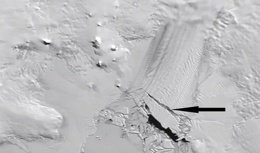
Ship trails in the Bay of Biscay observed using PROBA-V imagery
Ship trails have been perceived as convincing evidence of aerosol-cloud interaction. Ship emissions have been proven to contribute by about 1.9% and 2.9% to the increase in the global total and fine-mode aerosol optical thickness (AOT) respectively over a five year period (Peters et al. 20212).
News - Thematic area articles
 2 Feb 2022
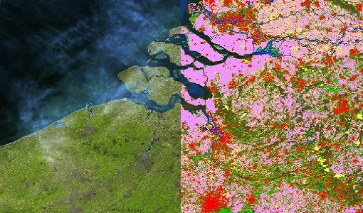
Satellite data boost global understanding of land surface
Understanding our changing land surface is essential in the study of climate change. Satellites are used to monitor changes to the material that covers Earth’s surface, so-called land cover, such as vegetation and water.
News - Success Stories
 1 Mar 2022
How Envisat helped to shape global understanding of Earth’s systems
Twenty years have passed since a ground-breaking European spacecraft designed to deliver unprecedented insight into the planet’s changing environment was lofted into orbit.
News - Thematic area articles
 2 Mar 2022
How space data are transforming the global food system
European Earth observation activities are accelerating a data-driven transformation in the agriculture sector that is helping farmers adapt to the dual challenges of climate change and population increase.
News - Spotlight on EO community
 4 Mar 2022
Introducing Mirko Albani
In this short introduction, ESA's Heritage Missions Programme Manager describes what he likes most about ESA's long term archive of satellite mission data and his role in the programme.
News - Spotlight on EO community
12 Apr 2022Interviewing Mirko Albani
ESA’s Heritage Space Programme Manager describes the goals of the programme, some of the challenges involved in preserving and improving 40 years of historical Earth observation data, and his passion for curating this long-term archive.
News - Events and Proceedings
 26 May 2022
Data preservation takes centre stage at Living Planet Symposium
Against the backdrop of the famed Rhine River, world-class scientists and Earth observation data-users are gathered this week in the historical city of Bonn, at the Living Planet Symposium (LPS).
News - Events and Proceedings
 13 June 2022
Highlights from Living Planet Symposium
As remote sensing scientists and data-users from around the world converged at the Living Planet Symposium (LPS) in Bonn recently, a common thread was evident in many scientific sessions and meetings – the right environmental data can accelerate our understanding of the rapid changes in Earth’s system.