- All Categories (292)
- Data (4)
- News (31)
- Missions (2)
- Events (19)
- Tools (13)
- Activities (8)
- Campaigns (2)
- Documents (213)
NEWS
Discover the latest news on the European Space Agency's Earth Observation activities. Learn all about new data availability and how ESA's missions are performing.
News - Events and Proceedings
 25 Oct 2021
Φ-Week Triumphs
In its fourth edition, Φ-Week presented the scientific community with amazing opportunities and projects—thus running alongside innovation at 360 degrees.
News - Success Stories
 5 July 2019
What's happening to Greenland's ice?
Heatwave conditions catapulted Greenland into an early Arctic summer in June, prompting widespread melting across its icesheet surface.
News - Success Stories
30 Aug 2023Synergy of space data helps modernise irrigation systems
The growing demands on agriculture, coupled with the climate crisis, are pressurising Earth’s valuable freshwater resources and making assessment of water practices ever more important.
News - Success Stories
 25 Sept 2018
Spotlight on sea-level rise
Scientists to share findings on how satellite has revealed changes in the height of the sea, ice, inland bodies of water and more.
News - Success Stories
 13 Dec 2021
Ship trails in the Bay of Biscay observed using PROBA-V imagery
Ship trails have been perceived as convincing evidence of aerosol-cloud interaction. Ship emissions have been proven to contribute by about 1.9% and 2.9% to the increase in the global total and fine-mode aerosol optical thickness (AOT) respectively over a five year period (Peters et al. 20212).
News - General News
 27 Sept 2018
Satellite Radar Altimetry: past and future
Satellite radar altimetry measurements yield a wealth of information that can be used for a wide range of applications.
News - Thematic area articles
 2 Feb 2022
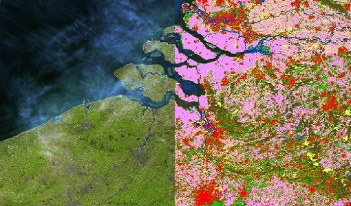
Satellite data boost global understanding of land surface
Understanding our changing land surface is essential in the study of climate change. Satellites are used to monitor changes to the material that covers Earth’s surface, so-called land cover, such as vegetation and water.
News - Thematic area articles
25 Apr 2023Remote sensing data map impacts of natural hazards
As climate change increases the frequency and severity of natural disasters, remote sensing data can warn about extreme events and help tackle emergency situations.
News - General News
 29 Apr 2021
Quality Reports Advanced Search Portal takes off
The Quality Reports Advanced Search (QRAS) Portal is a system that provides a set of functionalities for searching, filtering, visualising and downloading of Earth Observation reports data, from multiple missions.
News - General News
4 Oct 2023PROBA-V’s companion explores low-cost remote sensing
With the launch of PROBA-V’s Companion CubeSat (PV-CC), ESA supports a future where clusters of cheaper, small satellites could complement full-scale missions for Earth observation.
News - General News
 26 Oct 2021
PROBA-V, ready to close its green eyes
While the operational lifetime of the global PROBA-V mission already ended on 30 June 2020 after more than 7 years in orbit, its vegetation instrument remained capturing the European and African land mass in experimental mode ever since.
News - Data Release news
11 Apr 2023PROBA-V ‘Collection 2’ - Reprocessed Dataset available
The improved PROBA-V data (Collection 2) has been released. Data is available via the PROBA-V MEP and Terrascope platforms so users can freely exploit the data using Virtual machines, Jupyter Notebooks, and the new viewing application.
News - Operational News
 15 May 2019
PROBA-V global land cover maps released
Copernicus Global Land Service team have released their new set of global land cover layers for the year 2015.
News - Success Stories
8 May 2023PROBA-V data improve surface albedo products in Africa
As ESA’s PROBA-V satellite marks its 10-year launch milestone, data tasked during the mission’s lifetime are still being used to assess changes in land cover.
News - Data Release news
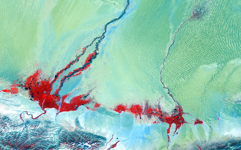
 5 Mar 2018
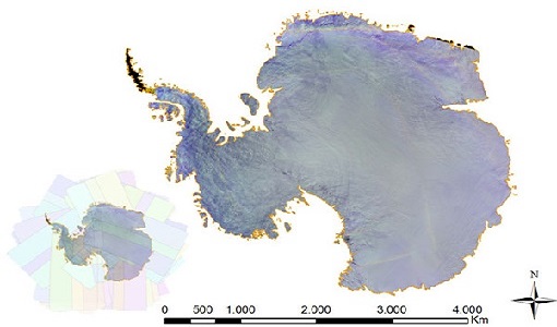
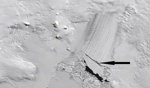
PROBA-V data available over Antarctica
Due to a huge amount of interest, it was decided to acquire PROBA-V data over Antarctica from November 2017 to February 2018.
News - Data Release news
 7 Mar 2019
PROBA-V 2018-2019 Antarctica data now available
For the second consecutive austral summer season, PROBA-V observed Antarctica and its ongoing changes.
News - Infographics
21 Apr 2020PROBA-V - ESA's vegetation monitoring mission
ESA's vegetation-monitoring mission - Proba-V - will end operations in June 2020 after seven years.
News - Success Stories
 17 Mar 2022
New open-source Python library improves rapid mapping services
In emergency services, rapid response is paramount. ICube-SERTIT’s Rapid Mapping Service provides near real-time delivery of geo-information to help emergency services respond quickly to disasters such as flooding, fires and landslides. A new Python open-source library, called EOReader, speeds up this mapping response by enabling the easy opening of imagery from multiple satellite sensors, both optical and synthetic aperture radar (SAR).
News - Operational News
 10 Aug 2020
New experimental phase for PROBA-V
PROBA-V has begun a new experimental phase that will continue through to October 2021.
News - Data Release news
 15 Dec 2020
New Campaign datasets available
A new set of datasets is available, acquired during airborne campaigns conducted between 2014 and 2019