- All Categories (983)
- Data (19)
- News (26)
- Missions (1)
- Events (24)
- Tools (4)
- Activities (8)
- Campaigns (1)
- Documents (900)
NEWS
Discover the latest news on the European Space Agency's Earth Observation activities. Learn all about new data availability and how ESA's missions are performing.
News - Success Stories
 16 May 2019
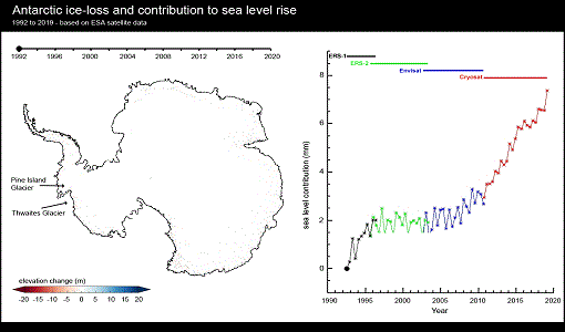
A quarter of glacier ice in West Antarctica is now unstable
Scientists have discovered warming ocean waters have caused ice to thin so rapidly that 24% of glacier ice in West Antarctica is now affected.
News - Events and Proceedings
 26 May 2022
Data preservation takes centre stage at Living Planet Symposium
Against the backdrop of the famed Rhine River, world-class scientists and Earth observation data-users are gathered this week in the historical city of Bonn, at the Living Planet Symposium (LPS).
News - Operational News
 4 Jan 2019
Envisat-ERS (A)SAR - Enhanced Dissemination Service
ESA is pleased to announce the release of several new features as part of the ESA On-The-Fly data processing and dissemination service.
News - Infographics
 16 July 2021
ERS - ESA’s first Earth observation satellites
To mark the 30th anniversary of ERS, we've released a new infographic summarising the mission.
News - Success Stories
 19 July 2021
ERS Heritage Data allow for 30 years of science
At their time of launch thirty years ago, the two ERS satellites were the most sophisticated Earth observation spacecraft ever developed and launched by Europe.
News - Data Release news
 13 June 2019
ERS-1 Scatterometer L2 dataset processed with ASPS v10.04 is available online
The reprocessed dataset together with corresponding ERS-2 data is now available.
News - Success Stories
 13 May 2019
ESA's Earth Explorers surpassing expectations
In this video, learn how each Earth Explorer mission is contributing to Earth science, and changing the way we look at our beloved planet.
News - General News
 8 Apr 2024
ESA's improved Earth system data records: what is in store for the future?
Fundamental Data Records (FDRs) are instrumental in advancing our understanding of Earth systems and for addressing societal challenges effectively. These long-term records contain uncertainty-quantified, calibrated and geo-located multi-instrument/multi-platform satellite sensor data spanning several decades to support climate-related applications.
News - Data Release news
8 Mar 2024FDR4ALT - ESA unveils new cutting-edge ERS/Envisat Altimeter and Microwave Radiometer Datasets
The European Space Agency (ESA) has developed a comprehensive suite of innovative Earth system data records as part of the Fundamental Data Records for Altimetry project - FDR4ALT.
News - Events and Proceedings
9 Apr 2024Featuring the power of Earth observation data at EGU
The European Geosciences Union General Assembly 2024 brings together geoscientists from all over the world, aiming to provide a forum where scientists and early career researchers can present their work and discuss their ideas with experts, in all fields of geoscience.
News - Thematic area articles
 29 Sept 2022
How satellite data help to shape society
Data from ESA’s Earth observation archives are improving understanding of the interactions between human activities and the environment, helping to power green economic development and boosting prosperity in Europe and beyond.
News - Spotlight on EO community
 12 Apr 2022
Interviewing Mirko Albani
ESA’s Heritage Space Programme Manager describes the goals of the programme, some of the challenges involved in preserving and improving 40 years of historical Earth observation data, and his passion for curating this long-term archive.
News - Spotlight on EO community
4 Mar 2022Introducing Mirko Albani
In this short introduction, ESA's Heritage Missions Programme Manager describes what he likes most about ESA's long term archive of satellite mission data and his role in the programme.
News - Success Stories
 30 Apr 2020
Mission continuity
Long-term availability of Earth observation data from a given instrument is crucial to many data users and their research—but just how does it work?
News - Thematic area articles
3 Mar 2023Monitoring water on Earth's surface
ESA's Earth observation satellites are playing a leading role in furthering our understanding of how Earth's terrestrial hydrosphere is being influenced by humankind.
News - Data Release news
 15 Dec 2020
New Campaign datasets available
A new set of datasets is available, acquired during airborne campaigns conducted between 2014 and 2019
News - Data Release news
 20 June 2018
New ERS-2 GOME Level 1 v5.1 dataset available online
A new GOME Level 1b dataset has been generated for the 16-year mission period bringing relevant quality improvements for the revised calibration approach, compensating aging and instrument degradation, and provide enhanced accessibility.
News - Data Release news
 22 July 2021
New reprocessing of datasets celebrates 30 years of ERS
The ERS programme celebrated its 30th anniversary on 17 July. Today, we are still exploiting ERS data and experts continue to work on improving the altimeter, radiometer and SAR data the programme acquired.
News - Thematic area articles
 31 Mar 2022
Satellite data central to ocean monitoring
Over 95% of Earth’s water is found in our oceans, and yet sadly, oceans are under stress from climate change and pollution. Monitoring our oceans is vital for Earth’s survival and satellites are the primary means of long-term and independent observation of our vast ocean bodies and their associated coastal zones.
News - General News
 27 Sept 2018
Satellite Radar Altimetry: past and future
Satellite radar altimetry measurements yield a wealth of information that can be used for a wide range of applications.