- All Categories (85)
- Data (6)
- News (44)
- Missions (4)
- Events (4)
- Tools (10)
- Activities (2)
- Documents (15)
NEWS
Discover the latest news on the European Space Agency's Earth Observation activities. Learn all about new data availability and how ESA's missions are performing.
News - Data Release news
 1 Mar 2019
ICEYE data familiarization phase for the Earthnet TPM programme continues with new ICEYE-X2 data
The ICEYE data familiarization phase freely offers ICEYE imagery over several demonstration sites
News - General News
 29 July 2019
Three new Third Party Missions under evaluation
ICEYE, PlanetScope and Spire under evaluation. Interested users can investigate suitability of the data for scientific and R&D activities.
News - Success Stories
1 Apr 2020New life for Landsat historical data
45 years of data, more than 1.8 million images, these are the numbers of an adventure started 48 years ago with the launch of the first Landsat satellite.
News - General News
 18 June 2020
ICEYE data available for assessment
The SAR user community is invited to participate to the call to assess the suitability of the ICEYE constellation, for science and EO-based applications.
News - General News
 29 Sept 2020
ESA's new DataCube service is now available
ESA is pleased to announce the deployment of a new service, called ESA PDGS-DataCube, enabling multi-temporal and pixel-based access to a subset of the data available in the European Space Agency dissemination services.
News - General News
 29 Sept 2020
ESA’s Earth Observation Catalogue and its services
EO-CAT is the EO Catalogue tool allowing users to search ESA and Third Party Mission collections.
News - Data Release news
 12 Feb 2021
New reprocessed Landsat data on a new dissemination server
The full ESA Landsat archive has been reprocessed with the latest version of the processor to provide a homogenous dataset covering MSS, TM and ETM+ data.
News - General News
 10 June 2021
Introducing the newest Third Party Mission: ICEYE
ESA's Earth Observation Programme Board has approved the integration of the ICEYE mission, as a Third Party Mission (TPM) within the framework of the ESA Earthnet programme.
News - Infographics
 23 Sept 2021
ESA Third Party Missions timeline
We've released a new timeline to illustrate the history of the ESA Third Party Missions.
News - Success Stories
 8 Oct 2021
Earth Observation data to improve navigation risk modelling and shipping routes
With the increased frequency of shipping activities, such as tourism and transport of freights, navigation safety has become a major concern. Even if new technologies have already supplied aids to pilots for navigation risk reduction, the International Maritime Organisation (IMO) reports that the majority of accidents could have been avoided by providing suitable input to the navigation decision-making process — this is where Earth Observation data can represent complementary information, to improve traffic monitoring and guidance along safe routes.
News - Events and Proceedings
 25 Oct 2021
Φ-Week Triumphs
In its fourth edition, Φ-Week presented the scientific community with amazing opportunities and projects—thus running alongside innovation at 360 degrees.
News - Infographics
 8 Nov 2021
An overview of ESA's Third Party Missions programme
ESA’s Third Party Missions programme consists of almost 50 satellite missions, which are owned by organisations around the world. ESA has agreements with these organisations to acquire, process, and distribute data from their missions
News - Infographics
 7 Dec 2021
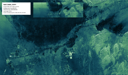
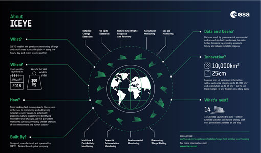
ICEYE – A persistent monitoring SAR constellation
Learn more about the ICEYE mission, a constellation of SAR satellites and part of ESA's Third Party Missions programme, in our latest infographic.
News - Success Stories
 20 Dec 2021
ICEYE, the World’s First SAR New Space Constellation
ICEYE is a revolutionary Finnish company that developed and launched the world’s first under-100 kilogram synthetic-aperture radar (SAR) satellites into orbit.
News - Infographics
 28 Jan 2022
Timeline to over 40 years of historical satellite missions
ESA's Heritage Space Programme preserves historical data from over 40 years of Earth observation missions.
News - Thematic area articles
 2 Mar 2022
How space data are transforming the global food system
European Earth observation activities are accelerating a data-driven transformation in the agriculture sector that is helping farmers adapt to the dual challenges of climate change and population increase.
News - Success Stories
 17 Mar 2022
New open-source Python library improves rapid mapping services
In emergency services, rapid response is paramount. ICube-SERTIT’s Rapid Mapping Service provides near real-time delivery of geo-information to help emergency services respond quickly to disasters such as flooding, fires and landslides. A new Python open-source library, called EOReader, speeds up this mapping response by enabling the easy opening of imagery from multiple satellite sensors, both optical and synthetic aperture radar (SAR).
News - Thematic area articles
 31 Mar 2022
Satellite data central to ocean monitoring
Over 95% of Earth’s water is found in our oceans, and yet sadly, oceans are under stress from climate change and pollution. Monitoring our oceans is vital for Earth’s survival and satellites are the primary means of long-term and independent observation of our vast ocean bodies and their associated coastal zones.
News - Events and Proceedings
 8 June 2022
VHR Data Quality in the limelight
In recent years, the satellite landscape has steadily expanded with a variety of very high resolution (VHR) commercial satellites, also emerging from new space providers. A result of this growth is an increased need to address data quality assurance.
News - Data Release news
 28 July 2022
Spot Extended Area mode added to ICEYE on-demand portfolio
As an evolution of Spot mode, Spot Extended Area products are now available with the same resolution of Spot data (ground resolution of 1 m) but enabling to cover the area of 225 km2 (15 x 15 km) in a single SAR image.