- All Categories (16911)
- Data (27)
- News (37)
- Missions (1)
- Events (36)
- Tools (9)
- Activities (6)
- Campaigns (2)
- Documents (16793)
NEWS
Discover the latest news on the European Space Agency's Earth Observation activities. Learn all about new data availability and how ESA's missions are performing.
News - General News
 27 Sept 2018
Satellite Radar Altimetry: past and future
Satellite radar altimetry measurements yield a wealth of information that can be used for a wide range of applications.
News - Operational News
 4 Jan 2019
Envisat-ERS (A)SAR - Enhanced Dissemination Service
ESA is pleased to announce the release of several new features as part of the ESA On-The-Fly data processing and dissemination service.
News - Success Stories
 16 May 2019
A quarter of glacier ice in West Antarctica is now unstable
Scientists have discovered warming ocean waters have caused ice to thin so rapidly that 24% of glacier ice in West Antarctica is now affected.
News - Data Release news
 12 July 2019
Updated Precise Orbit data (POD) for the full ERS-1 and ERS-2 mission available
The Precise Orbit files (ERS.ORB.POD) for the entire ERS-1 and ERS-2 mission periods have been reprocessed with up-to-date standards.
News - Success Stories
 30 Apr 2020
Mission continuity
Long-term availability of Earth observation data from a given instrument is crucial to many data users and their research—but just how does it work?
News - Infographics
 3 Dec 2020
Envisat - ESA's versatile Earth observation satellite
Learn more about ESA's Envisat mission - the largest Earth observation satellite ever built - in a new infographic.
News - Data Release news
 17 June 2021
ESA's (A)SAR dissemination service enhanced with Envisat ASAR MR L1 data
With integration of four additional Envisat ASAR Level 1 collections, ESA is now providing access to the complete Envisat and ERS (A)SAR imagery data archive via the ESA (A)SAR Online Dissemination service.
News - Data Release news
 29 Sept 2021
Release of new Envisat DORIS Precise Orbit data
A new version of the Envisat Precise Orbit products has been generated by the Centre de Traitement Doris Poseidon (CTDP) using the Geophysical Data Records F standards (GDR-F). The new dataset (DOR_VOR_AX vF) is now available to users in Envisat format from the ESA dissemination service.
News - Thematic area articles
 2 Feb 2022
Satellite data boost global understanding of land surface
Understanding our changing land surface is essential in the study of climate change. Satellites are used to monitor changes to the material that covers Earth’s surface, so-called land cover, such as vegetation and water.
News - Success Stories
 1 Mar 2022
How Envisat helped to shape global understanding of Earth’s systems
Twenty years have passed since a ground-breaking European spacecraft designed to deliver unprecedented insight into the planet’s changing environment was lofted into orbit.
News - Spotlight on EO community
 4 Mar 2022
Introducing Mirko Albani
In this short introduction, ESA's Heritage Missions Programme Manager describes what he likes most about ESA's long term archive of satellite mission data and his role in the programme.
News - Success Stories
9 Mar 202210 years of Envisat data help to illuminate ocean processes
A decade after Envisat beamed its final image to the planet, the pioneering ESA mission is continuing to foster improved understanding of Earth’s systems.
News - Spotlight on EO community
12 Apr 2022Interviewing Mirko Albani
ESA’s Heritage Space Programme Manager describes the goals of the programme, some of the challenges involved in preserving and improving 40 years of historical Earth observation data, and his passion for curating this long-term archive.
News - Events and Proceedings
 26 May 2022
Data preservation takes centre stage at Living Planet Symposium
Against the backdrop of the famed Rhine River, world-class scientists and Earth observation data-users are gathered this week in the historical city of Bonn, at the Living Planet Symposium (LPS).
News - Thematic area articles
 30 June 2022
Transforming space data into climate action
ESA’s Earth observation activities are playing a key role in the revitalised global drive to combat climate change.
News - Thematic area articles
 16 Aug 2022
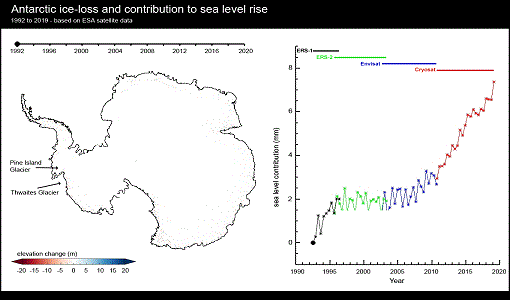
Satellites reveal changes to Earth’s icy zones
ESA’s Earth observation activities are helping scientists investigate the influence of climate change on widespread ice-losses across the planet.
News - Thematic area articles
 29 Sept 2022
How satellite data help to shape society
Data from ESA’s Earth observation archives are improving understanding of the interactions between human activities and the environment, helping to power green economic development and boosting prosperity in Europe and beyond.
News - Success Stories
 6 Oct 2022
Decades of satellite data reveal the risks of climate tipping points
Decades-long time series that draw on ESA’s Earth observation archives are enabling scientists to uncover the threat of sudden and potentially irreversible changes to the icy parts of the planet.
News - Thematic area articles
 2 Nov 2022
Satellites investigate Earth’s terrestrial hydrosphere
ESA’s Earth observation satellites are playing a leading role in furthering our understanding of how Earth’s water cycle is being influenced by humankind.
News - Success Stories
 10 Nov 2022
Long-term satellite data show wind farms can affect local air currents
Decades of satellite data have allowed for the first long-term study of the impact of offshore wind farms on downstream wind flow in coastal areas.