- All Categories (1160)
- Data (13)
- News (61)
- Missions (2)
- Events (21)
- Tools (14)
- Activities (2)
- Campaigns (3)
- Documents (1044)
NEWS
Discover the latest news on the European Space Agency's Earth Observation activities. Learn all about new data availability and how ESA's missions are performing.
News - Data Release news
 16 May 2018
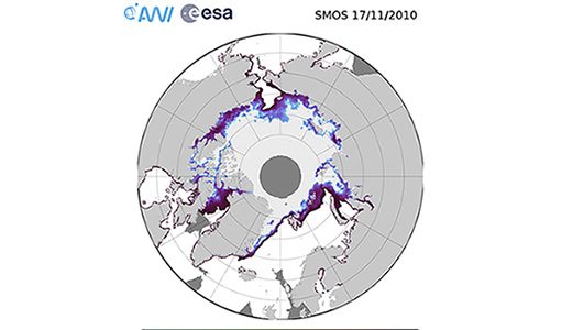
Eight years of SMOS Arctic sea ice thickness level now available from SMOS Data dissemination portal
Daily maps of sea ice thickness based on SMOS Observations, covering the winter seasons in the Arctic for the period of October-April from year 2010/2011 to year 2017/2018, are now available.
News - Success Stories
 13 May 2019
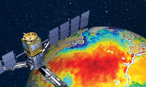
ESA's Earth Explorers surpassing expectations
In this video, learn how each Earth Explorer mission is contributing to Earth science, and changing the way we look at our beloved planet.
News - Success Stories
 14 May 2019
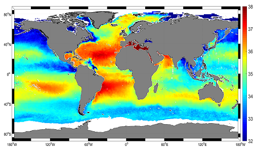
Mapping salty waters
The length and precision with which climate scientists can track the salinity, or saltiness, of the oceans is set to improve dramatically.
News - Events and Proceedings
 21 Oct 2019
Special event for 10th anniversary of SMOS
Earth Explorers for Climate - The contribution from SMOS - an event to mark the 10th anniversary of SMOS mission.
News - Data Release news
24 Mar 2020ALOS PALSAR WB1 Collection now available online
Area Observation Mode (Burst Mode 1) collection, which will complete the existing ALOS PALSAR data offer.
News - Data Release news
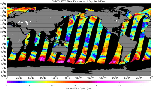
17 Apr 2020New SMOS sea surface wind speed products now available
The SMOS Wind Data Service provides, in near real time (NRT), surface wind speed over the ocean derived from the brightness temperature measurements of SMOS.
News - Success Stories
 24 Mar 2021
Water mission takes on space weather
Adding to SMOS’ list of talents, new findings show that what was considered noise in the mission’s data can actually be used to monitor solar activity and space weather, which can damage communication and navigation systems.
News - Infographics
 30 Mar 2021
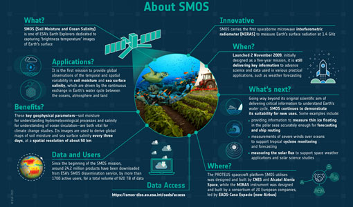
SMOS - ESA's soil moisture and ocean salinity mission
Learn more about the Soil Moisture and Ocean Salinity (SMOS) mission in our latest infographic.
News - Data Release news
28 May 2021SMOS level 1 and level 2 products new baseline is now available
New versions of the SMOS processors for level 1 and 2 were deployed in the operational ground segment on 25 May 2021.
News - Data Release news
24 June 2021Static Maps for ALOS African coverage available for users
ALOS Africa is a dataset of the best available (cloud minimal, below 10%) African coverage acquired by AVNIR-2 in OBS mode and PRISM in OB1 mode (all Backward, Nadir and Forward views, in separated products), two different collections one for each instrument.
News - Data Release news
 3 Aug 2021
New SMOS Level 1 Near Real Time processing baseline released
A new version of the SMOS level 1 Near Real Time processor - version 724 - was deployed in the operational ground segment on 2 August 2021.
News - Data Release news
 3 Aug 2021
New SMOS Level 2 Near Real Time Neural Network Soil Moisture baseline is released
A new version of the SMOS level 2 Near Real Time processor - version 300 - was deployed in the operational ground segment on 2 August 2021.
News - Data Release news
 4 Aug 2021
New SMOS Near Real Time Sea Surface Wind Speed new baseline is released
A new version of the SMOS Sea Surface Wind Speed processor - version 300 - was deployed at IFREMER and ESA operational ground segments on 4 August 2021.
News - Data Release news
 1 Sept 2021
ALOS AVNIR-2 L1C data collection now available
Through the Online Dissemination server, ESA offers registered users access to the ALOS-1 AVNIR-2 (Advanced Visible and Near Infrared Radiometer type 2) L1C data acquired by ESA stations in the ADEN zone, plus some worldwide data requested by European scientists.
News - Data Release news
18 Nov 2021SMOS sea ice thickness Arctic winter season 2021/2022 data available
SMOS Sea Ice thickness level 3 and level 4 data products are now available for the Arctic winter season 2021/2022.
News - General News
21 Dec 2021Updated SMOS documentation available
Updated versions of several SMOS data documents are now available.
News - Data Release news
 18 Jan 2022
SMOS sea ice thickness reprocessed data now available
The reprocessed SMOS level 3 and 4 sea ice thickness products over the Arctic are now available from the ESA SMOS Dissemination Service.
News - Thematic area articles
 2 Feb 2022
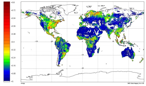
Satellite data boost global understanding of land surface
Understanding our changing land surface is essential in the study of climate change. Satellites are used to monitor changes to the material that covers Earth’s surface, so-called land cover, such as vegetation and water.
News - Thematic area articles
 2 Mar 2022
How space data are transforming the global food system
European Earth observation activities are accelerating a data-driven transformation in the agriculture sector that is helping farmers adapt to the dual challenges of climate change and population increase.
News - Data Release news
 24 Mar 2022
SMOS L2 Sea Surface Salinity products documentation updates
SMOS L2 Sea Surface Salinity product validation report is now available.