- All Categories (14938)
- Data (84)
- News (101)
- Missions (53)
- Events (52)
- Tools (8)
- Activities (11)
- Campaigns (19)
- Documents (14610)
MISSIONS
Explore the European Space Agency's Earth Observation satellite missions. Learn all about ESA's dedicated Earth Explorers or collaborations with other agencies through the Third Party Missions programme.
Mission - Earth Explorers

SMOS
The Soil Moisture and Ocean Salinity (SMOS) mission is dedicated to making global observations of soil moisture over land and salinity over oceans.
Mission - Earth Explorers

FLEX
The FLEX mission will provide global maps of vegetation fluorescence, which can be converted into an indicator of photosynthetic activity.
Mission - Earth Watch

PROBA-V
The PROBA-V mission provides multispectral images to study the evolution of the vegetation cover on a daily and global basis.
Mission - Third Party Missions

PROBA-1
PROBA-1 is a technology demonstration satellite that later became an operational Earth observation mission.
Mission - Earth Explorers

GOCE
ESA's Gravity field and Ocean Circulation Explorer (GOCE) mission mapped Earth's geoid very accurately, opening a window into Earth's interior structure as well as the currents circulating within the depths of its oceans.
Mission - Heritage Missions

Envisat
Envisat was ESA's successor to ERS. Envisat carried ten instruments aboard for a wide range of Earth observing fields. The mission was operational from 2002 to 2012.
Mission - Heritage Missions

ERS
The ERS programme was composed of two missions, ERS-1 and ERS-2, which together observed the Earth for 20 years, from 1991 to 2011.
Mission - Heritage Missions
MOS-1/1B
MOS-1 and 1B, Japan’s first marine observation satellites, were designed to monitor ocean currents, sea surface temperature, atmospheric water vapour, ocean chlorophyll levels, precipitation, and land vegetation.
Mission - Heritage Missions
KOMPSAT-1
KOMPSAT-1 (Korean Multi-Purpose Satellite), also known as Arirang-1, was a South Korean Earth observation satellite which was launched on 21 December 1999. KOMPSAT-1 operated for eight years until satellite operations ceased on 30 December 2007 due to a loss of contact.
Mission - Third Party Missions
FSSCat
The FSSCat mission was an innovative concept that consisted of two federated 6-Unit Cubesats, called ³Cat-5/A and ³Cat-5/B, which operated in support of the Copernicus Land and Marine Environment services.
Mission - Third Party Missions
Pléiades Neo
Pléiades Neo is a very high resolution optical constellation of two identical satellites phased at 180° from each other.
Mission - Third Party Missions

SAOCOM
The SAOCOM (SAtélite Argentino de Observación COn Microondas) satellite series represents Argentina's approved polarimetric L-band SAR constellation of two spacecraft. It's objective is to provide an effective Earth observation and disaster monitoring capability.
Mission - Copernicus Sentinels

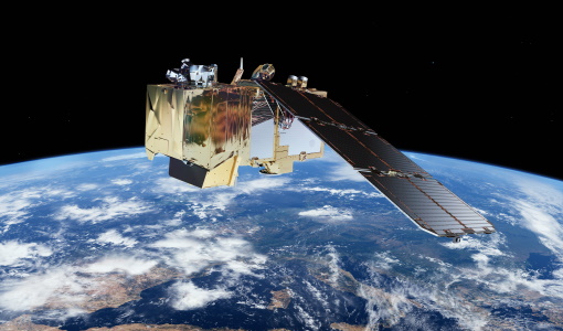
Copernicus Sentinel-3
Copernicus Sentinel-3 is an European Earth Observation satellite mission developed to support Copernicus ocean, land, atmospheric, emergency, security and cryospheric applications.
Mission - Copernicus Sentinels
Copernicus Sentinel-2
The Copernicus Sentinel-2 mission comprises a constellation of two polar-orbiting satellites placed in the same sun-synchronous orbit, phased at 180° to each other.
Mission - Third Party Missions

WorldView-4
WorldView-4 was an imaging and environment-monitoring satellite from Maxar of the United States, which offered very high resolution imagery.
Mission - Third Party Missions

WorldView-1
WorldView-1 helped meet the growing commercial demand for multi-spectral geospatial imagery.
Mission - Heritage Missions

IRS-1C and IRS-1D
The Indian Remote Sensing satellites IRS-1C and IRS-1D were identical Earth-imaging satellites operated by the Indian Space Research Organisation.
Mission - Heritage Missions

Landsat Series
The Landsat Series is the world's longest running system of satellites for moderate-resolution optical remote sensing for land, coastal areas and shallow waters.
Mission - Third Party Missions

WorldView Series
The WorldView constellation are environment-monitoring satellites that have been supplying imagery since 2007.
Mission - Heritage Missions
DMC First Generation
The Disaster Monitoring Constellation (DMC) is a constellation of microsatellites formerly coordinated by DMCii to provide frequent observations of the Earth for monitoring natural disasters.