- All Categories (102)
- Data (5)
- News (15)
- Missions (2)
- Events (7)
- Tools (5)
- Activities (2)
- Documents (66)
News - How to guides
HEDAVI Discover: a step-by-step guide
The Heritage Data Visualisation tool (HEDAVI) is a platform developed by the French Science Consulting for Earth Observation group, VisioTerra, which allows users to freely access over 40 years of ESA Earth Observation Heritage data, Third Party Missions and some Copernicus data.
News - Success Stories
Discover Earth like never before: the HEDAVI tool
The Heritage Data Visualisation tool, or HEDAVI, enables the analysis of global spatio-temporal dynamics of natural and artificial environments, covering over 40 years of ESA Earth Observation Heritage data, Third Party Missions and some Copernicus data.
News - Events and Proceedings
Workshop celebrates end of long-running PROBA-1 satellite
In January, ESA will mark the end of its long-running CHRIS sensor onboard the PROBA-1 satellite in a special workshop.
Data - Fast Registration with approval (Restrained)
ALOS PRISM L1C
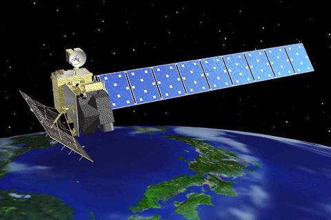
This collection provides access to the ALOS-1 PRISM (Panchromatic Remote-sensing Instrument for Stereo Mapping) OB1 L1C data acquired by ESA stations (Kiruna, Maspalomas, Matera, Tromsoe) in the ADEN zone, in addition to worldwide data requested by European scientists. The ADEN zone was the area belonging to the European Data node and covered both the European and African continents, a large part of Greenland and the Middle East. The full mission archive is included in this collection, though with gaps in spatial coverage outside of the ADEN zone. With respect to the L1B collection, only scenes acquired in sensor mode with a Cloud Coverage score lower than 70% and a sea percentage lower than 80% are published: Orbits: from 2768 to 27604 Path (corresponds to JAXA track number): from 1 to 665 Row (corresponds to JAXA scene centre frame number): from 310 to 6790. The L1C processing strongly improve accuracy compared to L1B1 from several tenths of metres in L1B1 (~40 m of northing geolocation error for Forward views and ~10-20 m for easting errors) to some metres in L1C scenes (< 10 m both in north and easting errors). The collection contains only the PSM_OB1_1C EO-SIP product type, using data from PRISM operating in OB1 mode with three views (Nadir, Forward, and Backward) at 35 km wide. Most of the products contain all three views, but the Nadir view is always available and is used for the frame number identification. All views are packaged together; each view, in CEOS format, is stored in a directory named according to the JAXA view ID naming convention.
News - Thematic area articles
Cloud-free collections key for land monitoring
Satellite imagery is a crucially important tool for monitoring the land, but cloud cover can often block parts of Earth’s surface from view, limiting subsequent analyses.
News - Data Release news
ALOS PRISM L1C European Coverage Cloud Free data collection now available for users
As part of Earthnet’s Third Party Missions Programme framework, ESA is pleased to announce that the ALOS PRISM L1C European Coverage Cloud Free data collection is now available for research purposes.
Data - Fast Registration with approval (Restrained)
ALOS PRISM L1C European Coverage Cloud Free
This collection is composed of a subset of ALOS-1 PRISM (Panchromatic Remote-sensing Instrument for Stereo Mapping) OB1 L1C products from the ALOS PRISM L1C collection (DOI: 10.57780/AL1-ff3877f) which have been chosen so as to provide a cloud-free coverage over Europe. 70% of the scenes contained within the collection have a cloud cover percentage of 0%, while the remaining 30% of the scenes have a cloud cover percentage of no more than 20%. The collection is composed of PSM_OB1_1C EO-SIP products, with the PRISM sensor operating in OB1 mode with three views (Nadir, Forward and Backward) at 35 km width.
News - Success Stories
New cross-calibration readies PROBA-1 data for climate research
While PROBA-1 has already exceeded expectations by suppling over 21 years of Earth observation hyperspectral data, recent cross-calibration activities are aiming to ensure the data will robustly serve long time-series research, even when the satellite ends operations.
News - Data Release news
ALOS PRISM Level 1C data collection now available for users
ESA offers registered users access to the ALOS PRISM (Panchromatic Remote-sensing Instrument for Stereo Mapping) OB1 L1C data acquired by ESA ground stations in the ADEN zone, plus some worldwide data requested by European scientists.
Document - Data Access Information
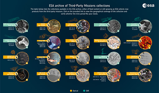
ESA-archive-third-party-mission-collections.pdf
Discover the ESA archive data collections offered for the Third Party Missions programme.
Tools - Catalogues
FedEO
FedEO is a data catalogue that provides a unique entry point to a number of scientific catalogues and services for, but not limited to, European and Canadian missions.
Tools - Catalogues
EO CAT
EO CAT is a data catalogue, offering a Next Generation Earth Observation system designed to manage end-user Earth Observation services.
Event - Conference
Dragon 3 2014 Symposium
The Dragon 3 2014 Symposium was part of the Dragon 3 Programme, focussed on exploitation of ESA, ESA's Third Party Missions and Chinese Earth observation data for geo-science and applications development in land, ocean and atmospheric applications.
Event - Conference
Dragon 3 2015 Symposium
The Dragon 3 2015 Symposium was part of the Dragon 3 Programme, focussed on exploitation of ESA, ESA's Third Party Missions and Chinese Earth observation data for geo-science and applications development in land, ocean and atmospheric applications.
Event - Conference
Dragon 3 2016 Symposium
The Dragon 3 2016 Symposium served as the close of the Dragon 3 Cooperation Programme (2012 to 2016) and formal kick off for Dragon 4 Cooperation projects.
Activity - Projects
Dragon 3 Cooperation Programme
The Dragon 3 Programme focussed on the exploitation of ESA, ESA's Third Party Missions and Chinese Earth observation data for geo-science and applications development in land, ocean and atmospheric applications.
Event - Conference
Living Planet Symposium 2022
Learn about the 2022 edition of ESA's Living Planet Symposium.
News - Infographics
A summary of ESA Third Party Mission collections
A new summary is available, showcasing the ESA archives for Third Party Mission collections.
News - Infographics
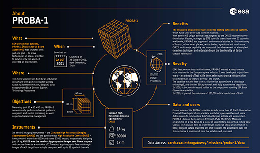
PROBA-1 - From technology demonstration to long-term Earth observation
Learn about ESA's PROBA-1 (Project for On-Board Autonomy) mission in our new infographic.
News - Events and Proceedings
Data preservation takes centre stage at Living Planet Symposium
Against the backdrop of the famed Rhine River, world-class scientists and Earth observation data-users are gathered this week in the historical city of Bonn, at the Living Planet Symposium (LPS).


