- All Categories (120)
- Data (12)
- News (13)
- Missions (4)
- Events (11)
- Tools (2)
- Campaigns (2)
- Documents (76)
News - General News
Go-to guide to Third Party Mission data offering
ESA’s latest Third Party Missions Data Access Guide has been published, providing technical details and information on available data collections for all current or past Third Party Missions.
News - Thematic area articles
How to use space data to probe humankind’s ancient past
Data disseminated by ESA’s Third Party Missions (TPM) programme are enabling archaeological investigations that could help to unravel the mysteries of past societies and cultures.
Data - Fast Registration with approval (Restrained)
ALOS PRISM L1C
This collection provides access to the ALOS-1 PRISM (Panchromatic Remote-sensing Instrument for Stereo Mapping) OB1 L1C data acquired by ESA stations (Kiruna, Maspalomas, Matera, Tromsoe) in the ADEN zone, in addition to worldwide data requested by European scientists. The ADEN zone was the area belonging to the European Data node and covered both the European and African continents, a large part of Greenland and the Middle East. The full mission archive is included in this collection, though with gaps in spatial coverage outside of the ADEN zone. With respect to the L1B collection, only scenes acquired in sensor mode with a Cloud Coverage score lower than 70% and a sea percentage lower than 80% are published: Orbits: from 2768 to 27604 Path (corresponds to JAXA track number): from 1 to 665 Row (corresponds to JAXA scene centre frame number): from 310 to 6790. The L1C processing strongly improve accuracy compared to L1B1 from several tenths of metres in L1B1 (~40 m of northing geolocation error for Forward views and ~10-20 m for easting errors) to some metres in L1C scenes (< 10 m both in north and easting errors). The collection contains only the PSM_OB1_1C EO-SIP product type, using data from PRISM operating in OB1 mode with three views (Nadir, Forward, and Backward) at 35 km wide. Most of the products contain all three views, but the Nadir view is always available and is used for the frame number identification. All views are packaged together; each view, in CEOS format, is stored in a directory named according to the JAXA view ID naming convention.
News - Thematic area articles
Cloud-free collections key for land monitoring
Satellite imagery is a crucially important tool for monitoring the land, but cloud cover can often block parts of Earth’s surface from view, limiting subsequent analyses.
News - Data Release news
ALOS PRISM L1C European Coverage Cloud Free data collection now available for users
As part of Earthnet’s Third Party Missions Programme framework, ESA is pleased to announce that the ALOS PRISM L1C European Coverage Cloud Free data collection is now available for research purposes.
Data - Fast Registration with approval (Restrained)
ALOS PRISM L1C European Coverage Cloud Free
This collection is composed of a subset of ALOS-1 PRISM (Panchromatic Remote-sensing Instrument for Stereo Mapping) OB1 L1C products from the ALOS PRISM L1C collection (DOI: 10.57780/AL1-ff3877f) which have been chosen so as to provide a cloud-free coverage over Europe. 70% of the scenes contained within the collection have a cloud cover percentage of 0%, while the remaining 30% of the scenes have a cloud cover percentage of no more than 20%. The collection is composed of PSM_OB1_1C EO-SIP products, with the PRISM sensor operating in OB1 mode with three views (Nadir, Forward and Backward) at 35 km width.
News - Success Stories
Commercial and international data for fire monitoring
As climate change sparks a surge in the frequency and intensity of wildfires, satellite data disseminated through ESA’s Third Party Missions (TPM) programme are helping scientists to track and investigate these potentially damaging natural events.
News - Success Stories
New worldwide dataset captures the planet in fine detail
Scientists have developed an open source planetwide dataset of high-resolution Earth observation imagery, thanks to commercial data delivered by ESA’s Third Party Missions (TPM) programme.
Event - Conference
Living Planet Symposium 2022
Learn about the 2022 edition of ESA's Living Planet Symposium.
Event - Workshop
Space and the Arctic 2009 Workshop
Temperatures in the Arctic are rising at an unprecedented rate. This workshop looked at the needs and challenges of working and living in the rapidly changing Arctic and explore how space-based services might help to meet those needs.
News - Infographics
An overview of ESA's Third Party Missions programme
ESA’s Third Party Missions programme consists of almost 50 satellite missions, which are owned by organisations around the world. ESA has agreements with these organisations to acquire, process, and distribute data from their missions
News - Events and Proceedings
Φ-Week Triumphs
In its fourth edition, Φ-Week presented the scientific community with amazing opportunities and projects—thus running alongside innovation at 360 degrees.
Data - Fast Registration with approval (Restrained)
ALOS AVNIR-2 L1C
This collection provides access to the ALOS-1 AVNIR-2 (Advanced Visible and Near Infrared Radiometer type 2) L1C data acquired by ESA stations in the ADEN zone plus some worldwide data requested by European scientists. The ADEN zone was the area belonging to the European Data node and covered both the European and African continents, a large part of Greenland and the Middle East. The full mission archive is included in this collection, though with gaps in spatial coverage Time window: from 2006-04-28 to 2011-04-20 Orbits: from 1375 to 27898 Path (corresponds to JAXA track number): from 1 to 670 Row (corresponds to JAXA scene centre frame number): from 370 to 5230. One single Level 1C product type is offered for the OBS instrument mode: AV2_OBS_1C. The Level 1C product is a multispectral image (three bands in VIS and one in NIR) in GEOTIFF format with 10 m resolution.
News - Data Release news
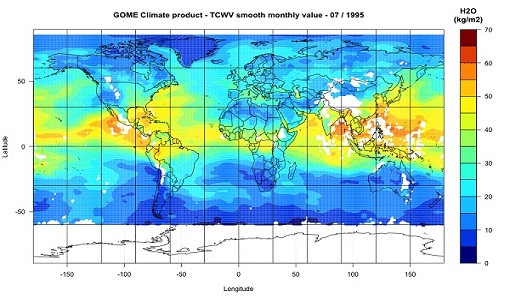
GOME TCWV Climate product available online
GOME Total Column Water Vapour (TCWV) Climate product developed within the ESA GOME-Evolution project is now accessible from the ESA data archives together with the ERS-2 GOME data.
Data - Project Proposal (Restrained)
SPOT-6 to 7 full archive and tasking
The SPOT 6 and 7 satellites ensure data continuity with the no longer operational SPOT 5 satellite and provide an archive of very high resolution optical acquisition as well as the possibility to task the satellites for new acquisitions. Following the completion of the SPOT 7 mission in March 2023, new acquisition tasking is only available for the SPOT 6 satellite. The ortho-products are automatically generated by the SPOT 6 and 7 ground segment, based on SRTM database or Reference3D when available. The projection available for SPOT 6 and 7 ortho-products is UTM, datum WGS84. Bands combinations: Pansharpened: colour image at 1.5 m resolution Bundle: 1.5 m panchromatic image and 6 m multispectral image. Geometric processing levels: Primary: The Primary product is the processing level closest to the natural image acquired by the sensor. This product restores perfect collection conditions: the sensor is placed in rectilinear geometry, and the image is clear of all radiometric distortion. Standard Ortho: The Ortho product is a georeferenced image in Earth geometry, corrected from acquisition and terrain off-nadir effects. Tailored ortho: Aside from the Standard Ortho product, when different specifications are needed, a custom orthorectification, with a more precise 3D model provided by the client or acquired for the purpose, can be provided on demand. As per ESA policy, very high-resolution imagery of conflict areas cannot be provided.
Tools - Other
Forestry TEP
The Forestry Thematic Exploitation Platform (TEP) enables users in the forestry sector to access satellite data based processing services and tools for generating value-added forest information products.
News - General News
OneAtlas Living Library subscription available for SPOT and Pléiades
To complement the traditional and fully customised ordering and download of selected Pléiades and SPOT images in a variety of data formats, users can now also request a subscription for access to the OneAtlas Living Library.
Document - Product Document
SPOT-Pleiades-data-terms-of-applicability.pdf
This document describes the terms of applicability for accessing data products from the SPOT and Pleiades missions.
Document - Proceedings
Fringe-2011-workshop-recommendations.pdf
This document contains the recommendations from the session summaries of the Fringe 2011 Workshop.
News - Data Release news
ALOS PRISM collection now open
A Japanese Earth-imaging satellite from JAXA, the Advanced Land Observing Satellite (ALOS-1) was part of ESA's Third Party Missions Programme, in which ESA has an agreement with JAXA to distribute its data products.


