- All Categories (24)
- Data (4)
- News (6)
- Missions (2)
- Tools (1)
- Documents (11)
News - Infographics
Explore sample data products from Third Party Missions
ESA’s Third Party Missions programme consists of over 50 satellite missions from commercial and public organisations worldwide.
Data - Sample Data (Open)
IRS-P6 (ResourceSat-1) Sample Data
Download free IRS-P6 (ResourceSat-1) sample datasets to preview products available for this mission.
News - Data Release news
Sample data products from ESA’s Third Party Missions
Samples of data products from a range of Third Party Missions are now available to download, offering a preview of what these missions provide.
News - Thematic area articles
Cloud-free collections key for land monitoring
Satellite imagery is a crucially important tool for monitoring the land, but cloud cover can often block parts of Earth’s surface from view, limiting subsequent analyses.
Document - General Reference

Heritage Space Programme interactive brochure
Learn about ESA's Heritage Space Programme in this interactive brochure.
Document - General Reference

Heritage Missions brochure
This brochure describes ESA's Heritage Space Programme and includes infographics describing some of the missions in the programme.
News - Infographics

Timeline to over 40 years of historical satellite missions
ESA's Heritage Space Programme preserves historical data from over 40 years of Earth observation missions.
News - General News

ESA and GAF AG continue to offer free-of-charge access to Third Party Mission data
In January 2021, ESA and GAF AG extended their agreement under ESA’s Third Party Missions programme regarding the provision of IRS data and DSMs until the end of 2021.
Document - Technical Note

Indian-Data-Terms-Of-Applicability.pdf
This document contains the Terms of Applicability and the Terms and Conditions for accessing the third party mission data from Indian data sources.
News - Success Stories

A stroll through Heritage Missions
At ESA's Earth Observation centre—ESRIN—in Frascati, Italy, there is a place where one can walk back in time, to better understand the history and importance of Heritage Missions and their data.
Document - Product Document

Image-2006-European-Coverage.pdf
GMES Fast Track Land Service 2006-2008 Orthorectification of SPOT and IRS-P6 products
Document - User Guide

TPM-L-OADS-dissemination-service-User-Manual.pdf
This guide describes the Third Party Missions Dissemination System.
Tools - Visualisation
EVDC Orbit Prediction Tool
The EVDC Orbit Prediction and Overpass Tool generates and visualises satellite's overpasses.
Data - Project Proposal (Restrained)
ResourceSat-1/IRS-P6 full archive
ResourceSat-1 (also known as IRS-P6) archive products are available as below: Sensor Type Resolution (m) Coverage (km x km) System or radiometrically corrected Ortho corrected (DN) Neustralitz archive Global archive LISS-IV Mono-Chromatic 5 70 x 70 X X 2004 – 2010 2003 - 2013 LISS-III Multi-spectral 20 140 x 140 X X 2004 – 2013 2003 - 2013 AWiFS Multi-spectral 60 370 x 370 X X 2004 – 2013 2003 - 2013 Note: LISS-IV: Mono-Chromatic, the band is selectable. In practice the red is used. For LISS-IV MN and LISS-III ortho corrected: If unavailable, user has to supply ground control information and DEM in suitable quality. For AWiFS ortho corrected: service based on in house available ground control information and DEM. The products are available as part of the GAF Imagery products from the Indian missions: IRS-1C, IRS-1D, CartoSat-1 (IRS-P5), ResourceSat-1 (IRS-P6) and ResourceSat-2 (IRS-R2) missions. 'ResourceSat-1 archive' collection has worldwide coverage: for data acquired over Neustrelitz footprint, the users can browse the EOWEB GeoPortal catalogue to search archived products; worldwide data (out the Neustrelitz footprint) can be requested by contacting GAF user support to check the readiness since no catalogue is not available. All details about the data provision, data access conditions and quota assignment procedure are described in the Terms of Applicability.
Data - Fast Registration with approval (Restrained)
Image 2006 European coverage
The Image 2006 collection is a SPOT-4, SPOT-5 and ResourceSat-1 (also known as IRS-P6) cloud free coverage over 38 European countries in 2006 (from February 2005 to November 2007). The Level 1 data provided in this collection originate from the SPOT-4 HRVIR instrument (with 20 m spatial resolution), from SPOT-5 HRG (with 10 m spatial resolution resampled to 20 m) and IRS-P6 LISS III (with 23 m spatial resolution), each with four spectral bands. The swath is of about 60 km for the SPOT satellites and 140 km for the IRS-P6 satellite. In addition to the Level 1, the collection provides the same data geometrically corrected towards a European Map Projection with 25 m resolution. Spatial coverage: Check the spatial coverage of the collection on a map available on the Third Party Missions Dissemination Service.
Data - Fast Registration with approval (Restrained)
IKONOS ESA archive
ESA maintains an archive of IKONOS Geo Ortho Kit data previously requested through the TPM scheme and acquired between 2000 and 2008, over Europe, North Africa and the Middle East. The imagery products gathered from IKONOS are categorised according to positional accuracy, which is determined by the reliability of an object in the image to be within the specified accuracy of the actual location of the object on the ground. Within each IKONOS-derived product, location error is defined by a circular error at 90% confidence (CE90), which means that locations of objects are represented on the image within the stated accuracy 90% of the time. There are six levels of IKONOS imagery products, determined by the level of positional accuracy: Geo, Standard Ortho, Reference, Pro, Precision and PrecisionPlus. The product provided by ESA to Category-1 users is the Geo Ortho Kit, consisting of IKONOS Black-and-White images with radiometric and geometric corrections (1-metre pixels, CE90=15 metres) bundled with IKONOS multispectral images with absolute radiometry (4-metre pixels, CE90=50 metres). IKONOS collects 1m and 4m Geo Ortho Kit imagery (nominally at nadir 0.82m for panchromatic image, 3.28m for multispectral mode) at an elevation angle between 60 and 90 degrees. To increase the positional accuracy of the final orthorectified imagery, customers should select imagery with IKONOS elevation angle between 72 and 90 degrees. The Geo Ortho Kit is tailored for sophisticated users such as photogrammetrists who want to control the orthorectification process. Geo Ortho Kit images include the camera geometry obtained at the time of image collection. Applying Geo Ortho Kit imagery, customers can produce their own highly accurate orthorectified products by using commercial off the shelf software, digital elevation models (DEMs) and optional ground control. Spatial coverage: Check the spatial coverage of the collection on a map available on the Third Party Missions Dissemination Service.
Mission - Heritage Missions
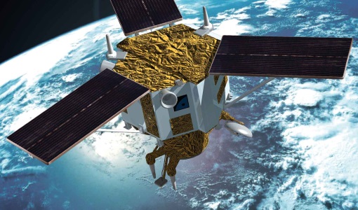
IRS-P6 (ResourceSat-1)
IRS-P6 (also known as ResourceSat-1) launched on 17 October 2003 from Satish Dhawan Space Centre by the Indian PSLV-C5, and came to an end on 30 September 2013.
Mission - Heritage Missions
IKONOS-2
At the time of its launch, IKONOS-2 brought imagery rivalling that of military satellites to the commercial market.
Document - Proceedings

Advances-in-Atmospheric-Science-and-Applications.pdf
Proceedings in Advances in Atmospheric Science and Applications held in 18-22 June 2012 in Bruges, Belgium.
Document - General Reference
BIOMASS-Report-for-Mission-Selection-An-Earth-Explorer-to-observe-forest-biomass.pdf
The objective of the BIOMASS Mission is to determine the global distribution of forest biomass by reducing the uncertainty in the calculation of carbon stock and fluxes associated with the terrestrial biosphere.