- All Categories (28)
- Data (1)
- News (12)
- Missions (1)
- Events (4)
- Tools (2)
- Activities (1)
- Documents (7)
Document - Conference Presentation - Poster

9_ApplicationsOfSARPolarimetry_Other.pdf
Session - Applications of SAR Polarimetry: Other
Document - Conference Presentation - Poster
7_POLinSAR2013_recommendations_land_applications.pdf
Applications of SAR Polarimetry on Land: Agriculture, Urban, Archaeology
Document - Conference Presentation - Poster
6_pres_polinsar_azzal.pdf
Analysis of a NLOS Canyon in an InSAR Image of a Urban area at KA-BAN A. Mokadem [Supelec - France]
Event - Workshop

2nd Space for Hydrology Workshop
The workshop aimed to assess the current stage of knowledge and activities in space-based hydrological observations and to exchange knowledge and know how with hydrologists and researchers.
Mission - Third Party Missions
Spire
Spire Global's constellation of Lemur nanosatellites offer satellite-based maritime, aviation and weather tracking.
Event - Conference

User Consultation for Infrastructures Planning and Monitoring Conference 2019
ESA hosted a joint DLR/ESA user consultation for infrastructures planning and monitoring conference on 26 and 27 February 2019.
News - Success Stories

Heritage data still widely used today
For about 30 years now, ESA satellites have been cruising some 800 km above our heads, collecting information about our planet-but why are older missions still so fundamental today?
News - General News

ICEYE data available for assessment
The SAR user community is invited to participate to the call to assess the suitability of the ICEYE constellation, for science and EO-based applications.
Data - Announcement of Opportunity (Restrained)

Announcement of Opportunity for NoR
ESA invites submissions for the Network of Resources (NoR) call, which aims to support research, development and pre-commercial users to innovate their working practices, moving from a data download paradigm towards a 'bring the user to the data' paradigm.
Document - Conference Presentation - Poster
4_POLinSAR2013_Ban_KTH.pdf
Multitemporal RADARSAT-2 Fine-Beam Polarimetric SAR for Urban Land Cover Mapping Y. Ban [KTH Royal Institute of Technology - Sweden]
Document - Conference Presentation - Poster
5_polinsar_Koeniguer.pdf
PolSARAP: Investigating the Benefits of Polarimetry for Urban Applications using X-Band SAR Images E. Koeniguer [ONERA - France]
Document - Conference Presentation - Poster
6_TROUVE_polinsar_2013_hybrid.pdf
Hybrid PolInSAR: High resolution & Polarimetry Applied to Urban N. Trouve [ONERA - France]
News - Success Stories

Using Satellite Data to Predict Floods and Droughts
Scientists are turning to remote sensing to fill the in-situ data gap in hydrological data models in some parts of the world.
Tools - Other

Hydrology TEP
The Hydrology Thematic Exploitation Platform (TEP) enables access, processing, uploading, visualisation, manipulation and comparison of hydrological data.
Tools - Other

Urban TEP
The Urban Thematic Exploitation Platform enables access, processing, uploading, visualisation, manipulation and comparison of data over urban areas.
News - Infographics
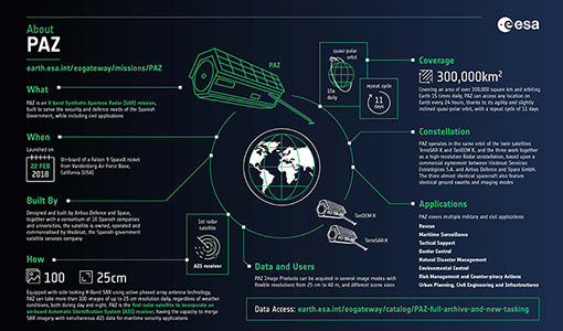
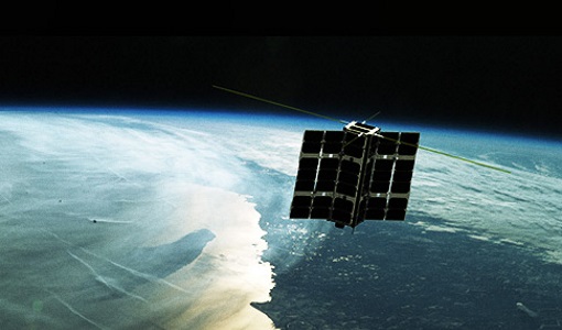
An overview of the PAZ SAR satellite mission
Learn more about the PAZ mission, a Spanish X-Band SAR satellite and part of ESA's Third Party Missions programme, in our latest infographic.
News - Infographics

PlanetScope and SkySat - The high-resolution nanosatellite constellation
Find out more about the PlanetScope and SkySat missions in our new infographic.
News - Infographics
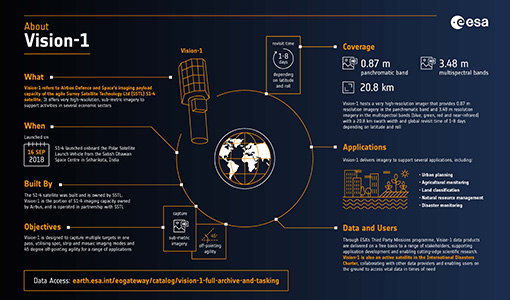
An overview of the very high-resolution Vision-1 satellite
Learn about Vision-1, which joined ESA's Third Party Missions programme in May, in our new infographic.
News - Data Release news

Spot Extended Area mode added to ICEYE on-demand portfolio
As an evolution of Spot mode, Spot Extended Area products are now available with the same resolution of Spot data (ground resolution of 1 m) but enabling to cover the area of 225 km2 (15 x 15 km) in a single SAR image.
Event - Training

EO Summer School 8
ESA's series of summer schools, on Monitoring of the Earth System, aims to promote the exploitation of Earth observation data.