- All Categories (29)
- Data (5)
- News (11)
- Missions (4)
- Events (4)
- Tools (2)
- Campaigns (3)
Event - Workshop

POLinSAR 2007
The POLinSAR 2007 workshop was open to ESA Principal Investigators and co-investigators, scientists and students working in the field of SAR Polarimetry and Polarimetric Interferometry, and to representatives from national, European and international space agencies and value adding industry.
Event - Workshop
2nd Space for Hydrology Workshop
The workshop aimed to assess the current stage of knowledge and activities in space-based hydrological observations and to exchange knowledge and know how with hydrologists and researchers.
Event - Workshop
BRIX-I: Workshop of First Biomass Retrieval Algorithm Inter-comparison Exercise
BRIX-I: Workshop of First Biomass Retrieval Algorithm Inter-comparison Exercise
Campaign

BioSAR 2007
The BioSAR campaign aimed to support geophysical algorithm development, calibration/validation and the simulation of future spaceborne Earth Observation missions.
Campaign

BioSAR 2010
The BioSAR-3 (BioSAR 2010) campaign was specifically planned and implemented to investigate possibilities for a future spaceborne P-band polarimetric and interferometric SAR with a life-time of multiple years.
Campaign

BioSAR 2008
The main objective of BioSAR-2 (BioSAR 2008) campaign was to record SAR data over boreal forests with topographic effects to investigate the effect on biomass retrieval.
Data - Campaigns (Open)
BioSAR 2007
The BioSAR campaign aimed to support geophysical algorithm development, calibration/validation and the simulation of future spaceborne Earth Observation missions.
Data - Campaigns (Open)
BioSAR 2008
The main objective of BioSAR-2 (BioSAR 2008) campaign was to record SAR data over boreal forests with topographic effects to investigate the effect on biomass retrieval.
Data - Campaigns (Open)

AfriSAR 2016
In order to further support the BIOMASS mission development, especially concerning the mission concept verification and the development of geophysical algorithms, ESA funded the AfriSAR campaign.
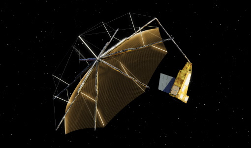
Mission - Earth Explorers
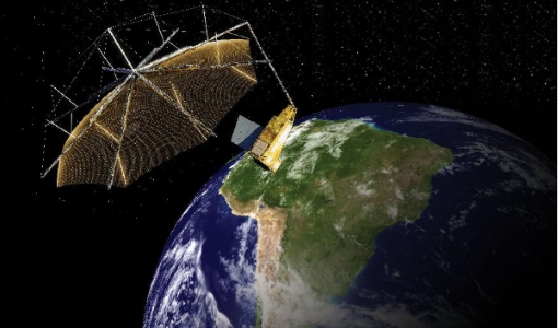
Biomass
The objective of the Biomass mission is to determine the global distribution of forest biomass.
Mission - Earth Watch

PROBA-V
The PROBA-V mission provides multispectral images to study the evolution of the vegetation cover on a daily and global basis.
News - General News

ICEYE data available for assessment
The SAR user community is invited to participate to the call to assess the suitability of the ICEYE constellation, for science and EO-based applications.
Event - Training

10th Advanced Training Course on Land Remote Sensing EO and AI for Forestry
This ESA course was dedicated to training the next generation of EO scientists and experts working in forestry domain to exploit data from EO missions and use AI for science and applications development.
Data - Announcement of Opportunity (Restrained)

Announcement of Opportunity for NoR
ESA invites submissions for the Network of Resources (NoR) call, which aims to support research, development and pre-commercial users to innovate their working practices, moving from a data download paradigm towards a 'bring the user to the data' paradigm.
News - Success Stories

Using Satellite Data to Predict Floods and Droughts
Scientists are turning to remote sensing to fill the in-situ data gap in hydrological data models in some parts of the world.
Tools - Other

Forestry TEP
The Forestry Thematic Exploitation Platform (TEP) enables users in the forestry sector to access satellite data based processing services and tools for generating value-added forest information products.
Tools - Other

Hydrology TEP
The Hydrology Thematic Exploitation Platform (TEP) enables access, processing, uploading, visualisation, manipulation and comparison of hydrological data.
News - Success Stories

Drone-based Laser Scanning of Tropical Forests for Biomass Cal/Val
ESA’s upcoming mission Biomass will deliver valuable P-band SAR data aimed at forest aboveground biomass (AGB) estimation across the humid tropics.
Mission - Third Party Missions

COSMO-SkyMed Second Generation
COSMO-SkyMed Second Generation is at the forefront of radar technology, will ensure improvements and guarantee continuity with the First Generation CSK satellites, preserving the high quality and the highest precision features, both required for the interferometric activities.
News - Success Stories
ESA's open source computing project for the Biomass mission goes live
The Biomass Product Algorithm Laboratory (BioPAL) is an open-source scientific computing project, which supports the development of ESA’s Biomass mission algorithms coded in Python.