- All Categories (278)
- Data (16)
- News (74)
- Missions (2)
- Events (13)
- Tools (19)
- Activities (6)
- Campaigns (3)
- Documents (145)
Document - Algorithms Theoretical Baseline Document

Aeolus Level 2A Algorithm Theoretical Baseline Document – AEL-FM and AEL-PRO products
This document describes Aeolus L2A Algorithm Theoretical Baseline
News - Events and Proceedings
Featuring the power of Earth observation data at EGU
The European Geosciences Union General Assembly 2024 brings together geoscientists from all over the world, aiming to provide a forum where scientists and early career researchers can present their work and discuss their ideas with experts, in all fields of geoscience.
News - How to guides
HEDAVI Discover: a step-by-step guide
The Heritage Data Visualisation tool (HEDAVI) is a platform developed by the French Science Consulting for Earth Observation group, VisioTerra, which allows users to freely access over 40 years of ESA Earth Observation Heritage data, Third Party Missions and some Copernicus data.
News - Maintenance News

ESA EO Dissemination Services - Maintenance on 25 and 26 March 2024
Scheduled software maintenance on ESA EO Dissemination Services on 25 and 26 March 2024
News - Operational News
Transition from FTP to FTPS for SMOS, Aeolus and Campaign data dissemination systems
As of 15 April 2024 access to the SMOS, Aeolus and Campaign data will be changed from simple FTP to FTPS.
News - General News
Go-to guide to Third Party Mission data offering
ESA’s latest Third Party Missions Data Access Guide has been published, providing technical details and information on available data collections for all current or past Third Party Missions.
News - General News
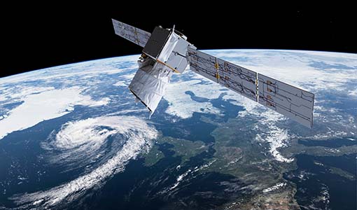
Aeolus wind data boosts innovative new global wind comparison tool
A new system for comparing wind data from multiple observing platforms, including ESA’s Aeolus wind satellite, puts global wind data - and the tools needed to analyse them - all in one place.
Tools - Apps
Earth Online Visuals
The Earth Online Visuals app displays interactive 3D models of ESA’s Earth Explorers and the Envisat and GOCE Heritage satellites. The models detail the mission payloads and where the instruments are placed on the satellites.
News - Success Stories
Discover Earth like never before: the HEDAVI tool
The Heritage Data Visualisation tool, or HEDAVI, enables the analysis of global spatio-temporal dynamics of natural and artificial environments, covering over 40 years of ESA Earth Observation Heritage data, Third Party Missions and some Copernicus data.
News - General News
Aeolus data and lessons learned: what happens next for ESA’s wind mission?
The Aeolus satellite returned to Earth on 28 July 2023, in an assisted reentry that marked the end of nearly five years in space. For scientists working with Aeolus data, however, the mission lives on.
News - Maintenance News
ESA EO Dissemination Services - Maintenance on 06 November 2023
Due to software maintenance on 06 November, several ESA Earth Observation data dissemination platforms will be unavailable.
News - Infographics
Overview of Aeolus Level-2b scientific wind data
Learn more about the Aeolus Level-2b scientific wind product in our latest infographic.
News - General News
3D Earth Online Visuals application takes off
A new app has just been launched, enabling you to explore ESA’s satellite missions in 3D and providing a new perspective on how satellite data contribute to our understanding of Earth systems, the climate, and their interactions.
Data - Fast Registration with approval (Restrained)
ALOS PRISM L1C
This collection provides access to the ALOS-1 PRISM (Panchromatic Remote-sensing Instrument for Stereo Mapping) OB1 L1C data acquired by ESA stations (Kiruna, Maspalomas, Matera, Tromsoe) in the ADEN zone, in addition to worldwide data requested by European scientists. The ADEN zone was the area belonging to the European Data node and covered both the European and African continents, a large part of Greenland and the Middle East. The full mission archive is included in this collection, though with gaps in spatial coverage outside of the ADEN zone. With respect to the L1B collection, only scenes acquired in sensor mode with a Cloud Coverage score lower than 70% and a sea percentage lower than 80% are published: Orbits: from 2768 to 27604 Path (corresponds to JAXA track number): from 1 to 665 Row (corresponds to JAXA scene centre frame number): from 310 to 6790. The L1C processing strongly improve accuracy compared to L1B1 from several tenths of metres in L1B1 (~40 m of northing geolocation error for Forward views and ~10-20 m for easting errors) to some metres in L1C scenes (< 10 m both in north and easting errors). The collection contains only the PSM_OB1_1C EO-SIP product type, using data from PRISM operating in OB1 mode with three views (Nadir, Forward, and Backward) at 35 km wide. Most of the products contain all three views, but the Nadir view is always available and is used for the frame number identification. All views are packaged together; each view, in CEOS format, is stored in a directory named according to the JAXA view ID naming convention.
News - Thematic area articles
Cloud-free collections key for land monitoring
Satellite imagery is a crucially important tool for monitoring the land, but cloud cover can often block parts of Earth’s surface from view, limiting subsequent analyses.
News - Data Release news
ALOS PRISM L1C European Coverage Cloud Free data collection now available for users
As part of Earthnet’s Third Party Missions Programme framework, ESA is pleased to announce that the ALOS PRISM L1C European Coverage Cloud Free data collection is now available for research purposes.
Data - Fast Registration with approval (Restrained)
ALOS PRISM L1C European Coverage Cloud Free
This collection is composed of a subset of ALOS-1 PRISM (Panchromatic Remote-sensing Instrument for Stereo Mapping) OB1 L1C products from the ALOS PRISM L1C collection (DOI: 10.57780/AL1-ff3877f) which have been chosen so as to provide a cloud-free coverage over Europe. 70% of the scenes contained within the collection have a cloud cover percentage of 0%, while the remaining 30% of the scenes have a cloud cover percentage of no more than 20%. The collection is composed of PSM_OB1_1C EO-SIP products, with the PRISM sensor operating in OB1 mode with three views (Nadir, Forward and Backward) at 35 km width.
News - Success Stories
Young scientists bid farewell to ESA's wind mission
Students and early career researchers are saying an emotional goodbye to Aeolus ahead of its upcoming reentry.
News - Spotlight on EO community
Meet the Quality Assurance for EO Team
The Quality Assurance For Earth Observation (also known as QA4EO) Service began its operations on 1 November 2019, providing support to the Data Quality and Algorithms Management Office at ESRIN, within the Sensor Performance, Processing and Algorithm section.
Document - Quality Report

Verification Report of the Third Reprocessing Campaign for First FM-A Period from September 2018 till June 2019
After the successful first and second Aeolus reprocessing campaigns covering the second Flight Model laser (FM-B) from 24 June 2019 to October 2020 ([RD-1] and [RD-2]), efforts were focused on the third reprocessing campaign covering the first operation period of Flight Model laser (FM-A) from 31 August 2018 to 16 June 2019