- All Categories (32)
- Data (8)
- News (14)
- Missions (5)
- Events (2)
- Tools (1)
- Activities (2)
Event - Meeting

VH-RODA and CEOS SAR workshop
The workshop provided an open forum for the presentation and discussion of current status and future developments related to the calibration and validation of space borne very high-resolution SAR and optical sensors and data products.
Data - Data Description
TropForest - ALOS, GEOSAT-1 & KOMPSAT-2 optical coverages over tropical forests
The objective of the ESA TropForest project was to create a harmonised geo-database of ready-to-use satellite imagery to support 2010 global forest assessment performed by the Joint Research Centre (JRC) of the European Commission and by the Food and Agriculture Organization (FAO). Assessments for year 2010 were essential for building realistic deforestation benchmark rates at global to regional levels. To reach this objective, the project aimed to create a harmonised ortho-rectified/pre-processed imagery geo-database based on satellite data acquisitions (ALOS AVNIR-2, GEOSAT-1 SLIM6, KOMPSAT-2 MSC) performed during year 2009 and 2010, for the Tropical Latin America (excluding Mexico) and for the Tropical South and Southeast Asia (excluding China), resulting in 1971 sites located at 1° x 1° geographical lat/long intersections. The project finally delivered 1866 sites (94.7% of target) due to cloud coverages too high for missing sites. Spatial coverage: Check the spatial coverage of the collection on a map available on the Third Party Missions Dissemination Service.
Activity - Quality
SLAP
The SLAP (Systematic Landsat Archive Processing) project covers the MSS, TM and ETM+ products from Landsat missions 1 – 7, and is the first systematic reprocessing of the ESA Landsat archive.
News - Thematic area articles
Remote sensing data map impacts of natural hazards
As climate change increases the frequency and severity of natural disasters, remote sensing data can warn about extreme events and help tackle emergency situations.
News - Data Release news

New reprocessed Landsat data on a new dissemination server
The full ESA Landsat archive has been reprocessed with the latest version of the processor to provide a homogenous dataset covering MSS, TM and ETM+ data.
News - Success Stories
New life for Landsat historical data
45 years of data, more than 1.8 million images, these are the numbers of an adventure started 48 years ago with the launch of the first Landsat satellite.
News - Data Release news
New data available: GEOSAT-2 Portugal Coverage 2021
A new collection is available to the public through ESA’s Earthnet Third Party Missions Programme: the GEOSAT-2 Portugal Coverage 2021.
Mission - Heritage Missions

Landsat-4 and Landsat-5
The Landsat-4 and Landsat-5 missions continued the Landsat programme's goal of providing moderate-resolution optical remote sensing for land, coastal areas and shallow waters.
Data - Data Description
Landsat TM ESA archive
This dataset contains all the Landsat-5 Thematic Mapper high-quality ortho-rectified L1T dataset acquired by ESA over the Fucino, Matera, Kiruna and Maspalomas visibility masks, as well as campaign data over Malindi, Bishkek, Chetumal, and Libreville. The acquired Landsat TM scene covers approximately 183 x 172.8 km. A standard full scene is nominally centred on the intersection between a path and row (the actual image centre can vary by up to 100 m). A full image is composed of 6920 pixels x 5760 lines and each band requires 40 MB of storage space (uncompressed) at 30 m spatial resolution in the VIS, NIR and SWIR as well as 120 m in the TIR spectral range. Kiruna Landsat TM GTC density map Maspalomas Landsat TM GTC density map Matera Landsat TM GTC density map
Mission - Heritage Missions

Landsat Series
The Landsat Series is the world's longest running system of satellites for moderate-resolution optical remote sensing for land, coastal areas and shallow waters.
Data - Data Description
Landsat MSS ESA Archive
This dataset contains all the Landsat 1 to Landsat 5 Multi Spectral Scanner (MSS) high-quality ortho-rectified Level 1 GEO and GTC dataset acquired by ESA over the Fucino, Kiruna (active from April to September only) and Maspalomas (on campaign basis) visibility masks. The acquired Landsat MSS scene covers approximately 183 x 172.8 km. A standard full scene is nominally centred on the intersection between a path and row (the actual image centre can vary by up to 200 m). The altitude changed from 917 km to 705 km and therefore two World Reference Systems (WRS) were used. A full image is composed of 3460 pixels x 2880 lines with a pixel size of 60 m. Two different product levels are available: Geometrically and terrain corrected GTC Products (L1T): The most accurate level of processing as they incorporate Ground Control Points (GCPs) and a Digital Elevation Model (DEM) to provide systematic geometric and topographic accuracy; with geodetic accuracy dependent on the number, spatial distribution and accuracy of the GCPs over the scene extent, and the resolution of the DEM used. Geometrically corrected GEO Product (L1G): Normally generated where there is a lack of GCPs, and are derived purely from data collected by the sensor and spacecraft e.g. ephemeris data. Matera density and coverage map Kiruna density and coverage map Maspalomas density and coverage map
Data - EO Sign In Authentication (Open)
Landsat 5 TM European and Mediterranean Countries Cloud Free Collection
This dataset contains the cloud-free products from Landsat 5 Thematic Mapper collection acquired over Europe, North Africa and the Middle East; for each scene only one product is selected, with the minimal cloud coverage. The acquired Landsat TM scene covers approximately 183 x 172.8 km. A standard full scene is nominally centred on the intersection between a path and row (the actual image centre can vary by up to 100 m). The data are system corrected.
News - Success Stories

How GEOSAT helps to unlock the potential of Earth observation data
High-resolution imagery delivered by a privately-owned system of European satellites is facilitating international efforts to boost prosperity, protect the environment, and tackle urgent global challenges.
News - Success Stories

Heritage data trains neural networks to detect urban sprawl
Using data from non-operational ESA remote sensing missions, researchers have trained a network of artificial neurons to recognise how cities change over decades. They hope this will help city planners reduce the impact that urbanisation has on the environment.
News - Data Release news
GEOSAT-2 Spain coverage new collection open for users
In the framework of ESA’s Earthnet Third Party Missions programme, we are glad to announce that there is a new collection open for users: the GEOSAT-2 Spain Coverage collection.
News - Data Release news
GEOSAT-2 Spain Coverage 2022 collection open to users
ESA’s Earthnet Third Party Missions Programme presents the latest addition to its collection: the GEOSAT-2 Spain Coverage 2022.
Data - Fast Registration with approval (Restrained)
GEOSAT-2 Spain Coverage
The GEOSAT-2 Spain Coverage collection consists of two separate coverages of Spain, including the Balearic and Canary islands, acquired by GEOSAT-2 between March and November of 2021 and 2022, respectively. The available imagery have a geolocation accuracy of < 4 m RMSE, a cloud cover percentage of < 10 %, and were acquired at an off-nadir angle from -30° to 30°. Spatial coverage of the 2021 collection. The following product types are available: Pan-sharpened: A four-band image, resulting from adding the information of each multispectral band to the panchromatic band. The fusion does not preserves all spectral features of the multispectral bands, so it should not be used for radiometric purposes. Resolution 1 m; Bands: All. Bundle: Panchromatic (1 m resolution) + Multispectral bands (4 m resolution): five-band image containing the panchromatic and multispectral products packaged together, with band co-registration. The available processing level is L1C orthorectified: a calibrated and radiometrically corrected product, manually orthorectified and resampled to a map grid. Property Spatial Resolution Pan-sharpened 1.0 m Bundle (PAN + MS) 1.0 m (PAN), 4.0 m (MS)
Data - Sample Data (Open)
GEOSAT-2 Sample Data
Download free GEOSAT-2 sample datasets to preview products available for this mission.
Data - Fast Registration with approval (Restrained)
GEOSAT-2 Portugal Coverage 2021
GEOSAT-2 Portugal coverage is a collection of 2021 data over the Portugal area, including islands. The available dataset has a cloud cover less than 10%, and is acquired up to 1m resolution with Geometric accuracy <6m CE90 based on Copernicus DEM @10m. GEOSAT-2 Portugal 2021 - Spatial Coverage of the Dataset The following product types are available: Pan-sharpened (4 bands, 321 Natural Colours or 432 False Colours): A four-band image, resulting from adding the information of each multispectral band to the panchromatic band. The fusion does not preserves all spectral features of the multispectral bands, so it should not be used for radiometric purposes. Resolution 1m; Bands: All, R-G-B or Ni-R-G Bundle: Panchromatic (1m resolution) + Multispectral bands (4m resolution): five-band image containing the panchromatic and multispectral products packaged together, with band co-registration. The available processing level is L1C orthorectified: a calibrated and radiometrically corrected product, manually orthorectified and resampled to a map grid. Product Type Processing Level and Spatial Resolution L1B (native) L1C (ortho) Pan-sharpened 1.0m 1.0m Bundle (PAN+MS) 1.0m (P), 4.0m (MS) 1.0m (P), 4.0m(MS)
Mission - Heritage Missions
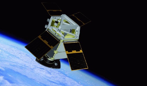
GEOSAT-2
GEOSAT-2 is the second satellite of the Deimos Earth Observation system, following GEOSAT-1.