- All Categories (44)
- News (3)
- Missions (2)
- Events (1)
- Tools (5)
- Activities (4)
- Documents (29)
Activity - General activities
EO Summer Schools
ESA's series of summer schools, on Monitoring of the Earth System, aims to promote the exploitation of Earth observation (EO) data.
News - Spotlight on EO community
Introducing Mirko Albani
In this short introduction, ESA's Heritage Missions Programme Manager describes what he likes most about ESA's long term archive of satellite mission data and his role in the programme.
Activity - Projects
Dragon 2 Cooperation Programme
The Dragon 2 Programme focussed on the exploitation of ESA, ESA's Third Party Missions and Chinese Earth observation data for science and applications development in land, ocean and atmospheric applications.
Tools - Apps
Heritage Missions app for iOS
Download the Heritage Missions application to discover what the missions were about, how it worked and what the elements of the space and ground segment that make these missions unique.
Tools - Apps
Heritage Missions app for Android
Download the Heritage Missions application to discover what the missions were about, how it worked and what the elements of the space and ground segment that make these missions unique.
News - Data Release news
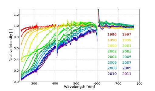
New ERS-2 GOME Level 1 v5.1 dataset available online
A new GOME Level 1b dataset has been generated for the 16-year mission period bringing relevant quality improvements for the revised calibration approach, compensating aging and instrument degradation, and provide enhanced accessibility.
Mission - Heritage Missions
Envisat
Envisat was ESA's successor to ERS. Envisat carried ten instruments aboard for a wide range of Earth observing fields. The mission was operational from 2002 to 2012.
Mission - Heritage Missions
ERS
The ERS programme was composed of two missions, ERS-1 and ERS-2, which together observed the Earth for 20 years, from 1991 to 2011.
Activity - Quality
SEOM CAWA
The Advanced Clouds, Aerosols and WAter vapour products for Sentinel-3/OLCI project aims to develop and improve the advanced atmospheric retrieval algorithms developed for MERIS and OLCI instruments.
Activity - Quality
REAPER
The REAPER (REprocessing of Altimeter Products for ERS) project covers both the ERS-1 and the ERS-2 altimetry missions. The project aims to support and maintain data quality.
Document - Algorithms Theoretical Baseline Document
MERIS ATBD 2-12
Pigment index, sediment and gelbstoff retrieval
Document - Algorithms Theoretical Baseline Document
MERIS ATBD 2-18
PHOTOSYNTHETICALLY AVAILABLE RADIATION (PAR)
Document - Algorithms Theoretical Baseline Document
MERIS ATBD 2-15
MERIS aerosol remote sensing over land
Document - Algorithms Theoretical Baseline Document
MERIS ATBD 2-22
MERIS Terrestrial Chlorophyll Index
Document - Algorithms Theoretical Baseline Document
MERIS ATBD 2-1
MERIS Cloud Albedo and Cloud Optical Thickness
Document - Algorithms Theoretical Baseline Document
MERIS ATBD 2-0
Introduction to MERIS Level 2 ATBDs
News - Data Release news
Updated Precise Orbit data (POD) for the full ERS-1 and ERS-2 mission available
The Precise Orbit files (ERS.ORB.POD) for the entire ERS-1 and ERS-2 mission periods have been reprocessed with up-to-date standards.
Document - Algorithms Theoretical Baseline Document
MERIS ATBD 2-01
CLOUD ALBEDO AND CLOUD OPTICAL THICKNESS


