- All Categories (283)
- Data (7)
- News (19)
- Missions (1)
- Events (15)
- Tools (8)
- Activities (5)
- Campaigns (1)
- Documents (227)
Document - Product Cal/Val Plan/Report

Validation Report following the 3rd MERIS data reprocessing
This document prepared by the MERIS Quality Working Group (QWG) corresponds to the Validation Report following the 3rd MERIS data reprocessing. It aims at qualifying and quantifying the accuracy of the MERIS L2 products generated with the version 8.0 of MERIS Ground Segment prototype (MEGS), delivered to the whole community through the ODESA software (http://earth.eo.esa.int/odesa/). It is equivalent to version 6.0 of the Instrument Processing Facilities (IPF) at ESRIN.
News - Data Release news

Updated Precise Orbit data (POD) for the full ERS-1 and ERS-2 mission available
The Precise Orbit files (ERS.ORB.POD) for the entire ERS-1 and ERS-2 mission periods have been reprocessed with up-to-date standards.
News - Thematic area articles
Tracking the world’s forests from space
As human activities continue to threaten the planet’s forests, data delivered by satellites are boosting global efforts to conserve these crucial natural resources.
Document - Campaign Report

SPARC-2004-data-acquisition-report.pdf
SPARC-2004 campaign objective was to collect a CHRIS/PROBA reference dataset for SPECTRA-related studies.
Data - Campaigns (Open)

SPARC
ESA's SPectra bARrax Campaign (SPARC) activity was part of the preparatory study for a proposed ESA Earth Explorer mission called SPECTRA. The objective was to collect a CHRIS/PROBA reference dataset for SPECTRA-related studies.
News - Thematic area articles
Space data support Earth’s ecosystems
ESA’s Earth observation (EO) missions are making a critical contribution to monitoring transformations in our planet’s ecosystems, helping track changes in the vegetation, soil, and ocean that affect these systems.
Tools - Analysis

SNAP
SNAP is a common architecture for all Sentinel Toolboxes. It is ideal for Earth observation processing and analysis.
Activity - Quality
SEOM CAWA
The Advanced Clouds, Aerosols and WAter vapour products for Sentinel-3/OLCI project aims to develop and improve the advanced atmospheric retrieval algorithms developed for MERIS and OLCI instruments.
Tools - Analysis

Sentinel-3 Toolbox
The Toolbox consists of a set of visualisation, analysis and processing tools for the exploitation of OLCI and SLSTR data.
Campaign

SEN3EXP
The main objective of Sen3Exp (Sentinel-3 Experimental Campaign) was to provide a comprehensive dataset that covers all Sentinel-3 OLCI and SLSTR bands that is to be used for the algorithm prototype and ground segment processor development.
News - Data Release news
Release of Envisat MERIS 4th reprocessing data
The data from the 4th MERIS reprocessing has been released to users and is now freely available from the new ESA Online Dissemination Service for MERIS.
Document - Technical Note

Reference Model for MERIS Level 2 Processing
The specifications provided here define the parameters to be used to generate inherent optical properties for the ocean and atmosphere as a function of geophysical properties and wavelengths, which can be the basis upon which to generate test data and auxiliary parameters needed for operation and end-to-end tests of the MERIS ground segment processor (i.e., mostly to generate water-leaving reflectances or total reflectances at the top of the atmosphere level). Parameters have been selected from various measurements and models in water, surface and atmosphere.
Document - Technical Note
Radiative transfer processes simulated within a coupled 'Atmosphere-Land-Ocean' system
The purpose of this document is to describe the radiative transfer processes simulated within a coupled 'Atmosphere-Land/Ocean' system by two different codes developed by ???? Freie Universit??t Berlin ???? (FUB) in Germany and ???? Laboratoire Interdisciplinaire en Sciences de l'Environnement - Universit?��� du Littoral (LISE/UdL) in France.
Document - Proceedings

PolInSAR-2007-Proceedings-of-the-3rd-International-Workshop-on-Science-and-Applications-of-SAR-Polarimetry-and-Polarimetric-Interferometry.pdf
Proceedings of PolInSAR 2007 held in Frascati, Italy on from 22-26 January 2007.
Tools - Analysis
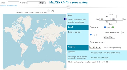
Optical Data processor of the European Space Agency
ODESA system provides a complete Level 2 processing environment for the MERIS instrument and future Sentinel-3 optical sensors.
Document - General Reference

Monitoring-Marine-Life-from-Space-Envisat-Experience-in-Chile.pdf
This article was published in the ESA Bulletin Nr. 126 and describes the use of satellite data for monitoring the environmental conditions of coastal waters and the health of southern oceans.
Document - Product Document

mkl3_product_handbook_is1r0.pdf
Envisat Meris Level 3 Demonstration Products
Document - Product Document
mgvi_demo_level3_description.pdf
Envisat Meris Level 3 Demonstration Products