- All Categories (87)
- Data (3)
- News (3)
- Missions (5)
- Events (2)
- Documents (74)
News - Thematic area articles
Cloud-free collections key for land monitoring
Satellite imagery is a crucially important tool for monitoring the land, but cloud cover can often block parts of Earth’s surface from view, limiting subsequent analyses.
Data - EO Sign In Authentication (Open)
Landsat RBV
This dataset contains Landsat 3 Return Beam Vidicon (RBV) products, acquired by ESA by the Fucino ground station over its visibility mask. The data (673 scenes) are the result of the digitalization of the original 70 millimetre (mm) black and white film rolls. The RBV instrument was mounted on board the Landsat 1 to 3 satellites between 1972 and 1983, with 80 metre resolution. Three independent co-aligned television cameras, one for each spectral band (band 1: blue-green, band 2: yellow-red, band 3: NIR), constituted this instrument. The RBV system was redesigned for Landsat 3 to use two cameras operating in one broad spectral band (green to near-infrared; 0.505–0.750 µm), mounted side-by-side, with panchromatic spectral response and higher spatial resolution than on Landsat 1 and Landsat 2. Each of the cameras produced a swath of about 90 km (for a total swath of 180 km), with a spatial resolution of 40 m.
News - Success Stories
New worldwide dataset captures the planet in fine detail
Scientists have developed an open source planetwide dataset of high-resolution Earth observation imagery, thanks to commercial data delivered by ESA’s Third Party Missions (TPM) programme.
Document - Technical Note
ESRIN-ERS-Central-Facility-GAP-Files-Interface-Specification.pdf
This document specifies the interface through which files of data related to the Global Activity Plan (GAP), stored in the ESRIN ERS Central Facility (EECF), are transmitted to the external entities. The EECF systems involved in this data exchange are the Interface Subset (ISS), responsible for telecommunication aspects and preprocessing, and the Central User Service (CUS), where the GAP resides.
Document - Technical Note
ERS-National-and-Foreign-Stations-Operators-Working-Group.pdf
This document presents material from the ERS National and Foreign Ground Station Operators Working Group Meeting, which took place in Toulouse, France, from 14 to 15 December 1995.
Data - Project Proposal (Restrained)
SPOT-6 to 7 full archive and tasking
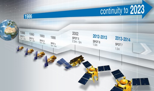
The SPOT 6 and 7 satellites ensure data continuity with the no longer operational SPOT 5 satellite and provide an archive of very high resolution optical acquisition as well as the possibility to task the satellites for new acquisitions. Following the completion of the SPOT 7 mission in March 2023, new acquisition tasking is only available for the SPOT 6 satellite. The ortho-products are automatically generated by the SPOT 6 and 7 ground segment, based on SRTM database or Reference3D when available. The projection available for SPOT 6 and 7 ortho-products is UTM, datum WGS84. Bands combinations: Pansharpened: colour image at 1.5 m resolution Bundle: 1.5 m panchromatic image and 6 m multispectral image. Geometric processing levels: Primary: The Primary product is the processing level closest to the natural image acquired by the sensor. This product restores perfect collection conditions: the sensor is placed in rectilinear geometry, and the image is clear of all radiometric distortion. Standard Ortho: The Ortho product is a georeferenced image in Earth geometry, corrected from acquisition and terrain off-nadir effects. Tailored ortho: Aside from the Standard Ortho product, when different specifications are needed, a custom orthorectification, with a more precise 3D model provided by the client or acquired for the purpose, can be provided on demand. As per ESA policy, very high-resolution imagery of conflict areas cannot be provided.
Document - Technical Note
Landsat 7 ETM Image Assessment System Radiometric Algorithm Theoretical Basis Document
Document - Technical Note
Landsat 7 ETM Image Assessment System Geometric Algorithm Theoretical Basis Document
News - Success Stories
New life for Landsat historical data
45 years of data, more than 1.8 million images, these are the numbers of an adventure started 48 years ago with the launch of the first Landsat satellite.
Data - Fast Registration with approval (Restrained)
SPOT 6 and 7 ESA archive
The SPOT 6 and 7 ESA archive is a dataset of SPOT 6 and SPOT 7 products that ESA collected over the years. The dataset regularly grows as ESA collects new SPOT 6 and 7 products. SPOT 6 and 7 Primary and Ortho products can be available in the following modes: Panchromatic image at 1.5m resolution Pansharpened colour image at 1.5m resolution Multispectral image in 4 spectral bands at 6m resolution Bundle (1.5m panchromatic image + 6m multispectral image) Spatial coverage: Check the spatial coverage of the collection on a map available on the Third Party Missions Dissemination Service. As per ESA policy, very high-resolution imagery of conflict areas cannot be provided.
Mission - Heritage Missions
Landsat Series
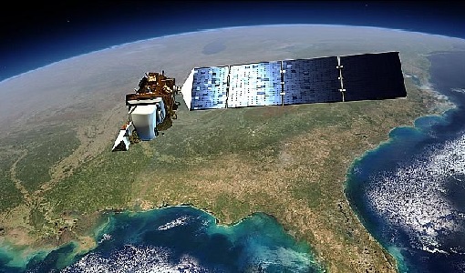
The Landsat Series is the world's longest running system of satellites for moderate-resolution optical remote sensing for land, coastal areas and shallow waters.
Mission - Heritage Missions
SPOT
The SPOT (from French "Satellite pour l'Observation de la Terre") series of missions has been supplying high-resolution, wide-area optical imagery since 1986.
Document - General Reference
Land and Sea - ERS-1 Applications
The information sheets in this brochure describe just some of the many projects utilising data products and images from ERS-1.
Document - General Reference
ERS - Envisat Symposium - Looking down to Earth in the New Millennium
The abstracts from the ERS-Envisat Symposium "Looking down to Earth in the new Millennium", which took place in Gothenburg, Sweden, from 16 to 20 October 2000 are presented here.
Document - General Reference
DRAGON 2 Programme - Brochure 2009
The Dragon Programme is a cooperation between ESA and the Ministry of Science and Technology (MOST) of the P.R. China. This brochure presents the activities undertaken since the formal start of the programme in April 2009, its background, objectives, partners and project themes.
Document - Technical Note
Landsat MSS State Vector Generation
Technical note describing the validation activities conducted to assess the geolocation accuracy and internal image geometry of the Landsat MSS products.
Document - Technical Note
Landsat Level 1 GTC MSS Geometric Validation
Technical Note detailing the results of the geometric validation of the ESA Landsat MSS products.
Document - Technical Note
ngEO Browse Report File Generic Interface (BRGICD)
Statistical description of the ngEO Generic Browse Report File.
Document - Proceedings
Earth Observation for Land-Atmosphere Interaction Science
Proceedings of the Topical Conference Earth Observation for Land-Atmosphere Interaction Science held from 3-5 November 2010 at the premises of ESA-ESRIN in Frascati (Rome) Italy.
Document - Proceedings
Dragon Programme Mid-Term Results
Proceedings of the 2005 Dragon Symposium held on 27 June - 1 July 2005 in Santorini, Greece.


