- All Categories (28)
- Data (2)
- News (9)
- Missions (1)
- Events (11)
- Activities (3)
- Documents (2)
News - Data Release news
FDR4ALT - ESA unveils new cutting-edge ERS/Envisat Altimeter and Microwave Radiometer Datasets
The European Space Agency (ESA) has developed a comprehensive suite of innovative Earth system data records as part of the Fundamental Data Records for Altimetry project - FDR4ALT.
News - Operational News

Temporary interruption to Envisat AATSR dissemination service
A planned downtime will affect the access to the ftp dissemination server for the Envisat AATSR data during the period 13-15 February 2024.
News - Infographics
Focusing on Envisat MERIS Full Resolution Level-2 data
ESA's Envisat mission continued and expanded upon the legacy of its predecessors, the ERS (European Remote Sensing) satellites. Operating between 2002 and 2012, the satellite's 10 instruments acquired a decade of data for many applications.
News - Events and Proceedings
Scientists to showcase value of Earth observation data at EGU
Remote sensing scientists are getting ready to present innovative and exciting applications of satellite data at the European Geosciences Union general assembly which will take place from 24 to 28 April in Vienna, Austria.
News - Success Stories
Envisat data show how volcanoes communicate with each other
Using radar data from ESA’s Envisat mission, scientists have recently proven the elastic interaction between two Hawaiian volcanoes.
Activity - General activities
EO Summer Schools
ESA's series of summer schools, on Monitoring of the Earth System, aims to promote the exploitation of Earth observation (EO) data.
News - Spotlight on EO community

Meet a young researcher who studies the behaviour of volcanoes worldwide
Researcher Camila Novoa Lizama, of the University of Leeds, recently analysed how the use of Synthetic Aperture Radar (SAR) imagery over the Puyehue Cordón-Caulle Volcanic Complex, in Chile, acquired by ALOS-1, Envisat and the Copernicus Sentinel-1 satellites, helped her team to better comprehend the temporal and spatial behaviour of ground displacements before, during and after the volcano’s last eruption.
Event - Training

EO Summer School 8
ESA's series of summer schools, on Monitoring of the Earth System, aims to promote the exploitation of Earth observation data.
Event - Training
EO Summer School 7
ESA's series of summer schools, on Monitoring of the Earth System, aims to promote the exploitation of Earth observation data.
Activity - General activities

International Charter Space and Major Disasters
Learn about the International Charter Space and Major Disasters, which ESA participate in disaster monitoring.
News - Events and Proceedings

Data preservation takes centre stage at Living Planet Symposium
Against the backdrop of the famed Rhine River, world-class scientists and Earth observation data-users are gathered this week in the historical city of Bonn, at the Living Planet Symposium (LPS).
News - Success Stories

How Envisat helped to shape global understanding of Earth’s systems
Twenty years have passed since a ground-breaking European spacecraft designed to deliver unprecedented insight into the planet’s changing environment was lofted into orbit.
Event - Workshop

Fringe 2003 Workshop
The third ESA International Workshop on ERS SAR Interferometry and its first Workshop on ASAR interferometry: Advances in SAR interferometry from ERS and Envisat missions.
Activity - Projects
Dragon Cooperation Programme
The Dragon Programme focussed on science and applications development in China using mainly data from the ERS and Envisat missions. The Prgramme was a cooperation between ESA and the National Remote Sensing Centre of China.
News - Data Release news
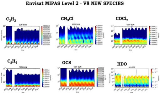
New Envisat MIPAS L2 dataset reprocessed with ORM v8.22 available
The Level 2 reprocessing of the full Envisat MIPAS mission with the ESA ORM processor version 8.22 has been completed.
Document - Proceedings

Fringe-2011-workshop-recommendations.pdf
This document contains the recommendations from the session summaries of the Fringe 2011 Workshop.
Event - Conference

GRSG 2015 Conference
The 26th Annual GRSG Conference 'Challenges in Geological Remote Sensing' focused on a wide range of remote sensing applications, tools, latest developments and sensors.
Event - Workshop

Fringe 2011 Workshop
Fringe 2011 was the 8th International Workshop on "Advances in the Science and Applications of SAR Interferometry".
Data - Fast Registration with immediate access (Open)

Envisat DORIS Doppler [DOR_DOP_1P]
This product was generated by the Centre de Traitement Doris Poseidon (CTDP). The DORIS Doppler product (DOR_DOP_1P) was consolidated offline 2-4 weeks after sensing and stored in the F-PAC archive. The file size is 0.5 Mbytes per orbit.
Data - Fast Registration with immediate access (Open)
Envisat DORIS Precise Orbit [DOR_VOR_AX]
The latest version of the Envisat DORIS Precise Orbit product, DOR_VOR_AX, was generated by the Centre de Traitement Doris Poseidon (CTDP) using the Geophysical Data Records F standards (GDR-F). The product is used to obtain the satellite orbital parameters (latitude, longitude, height and height rate) by using orbit computation routines. The most significant changes related to the GDR-F standards concern the new ocean tide model (FES2014) and the updated Terrestrial Reference Frame (ITRF2014). The new standards significantly improve all Precise Orbit Determination (POD) metrics with respect to GDR-E. The mean difference and variance of Sea Surface Height (SSH) at crossovers is slightly reduced. The DOR_VOR_AX product adopts the Envisat format, and the size is 0.2 Mbytes per orbit. Users are recommended to apply the GDR-F version, but the previous datasets are still available (i.e. GDR-D and GDR-E versions). See further details in the readme file for Envisat DORIS Precise Orbit Determination files. Comparison of Envisat Sea Level Anomaly trends obtained using DORIS Precise Orbit GDR-E and F standards. North/South patterns are evident. Credits: CNES/CLS.