- All Categories (23)
- Data (7)
- News (6)
- Missions (3)
- Events (2)
- Tools (4)
- Documents (1)
Data - Sample Data (Open)
GEOSAT-2 Sample Data
Download free GEOSAT-2 sample datasets to preview products available for this mission.
News - Data Release news
GEOSAT-2 Spain Coverage 2022 collection open to users
ESA’s Earthnet Third Party Missions Programme presents the latest addition to its collection: the GEOSAT-2 Spain Coverage 2022.
News - General News
GEOSAT collaborates with ESA to boost understanding of the planet
Researchers around the world are exploring innovative scientific applications of high quality satellite data from commercial provider GEOSAT, thanks to a successful collaboration between the firm and ESA’s Third Party Missions (TPM) programme.
News - Data Release news
GEOSAT-2 Spain coverage new collection open for users
In the framework of ESA’s Earthnet Third Party Missions programme, we are glad to announce that there is a new collection open for users: the GEOSAT-2 Spain Coverage collection.
Data - Fast Registration with approval (Restrained)
GEOSAT-2 Spain Coverage
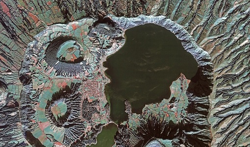
The GEOSAT-2 Spain Coverage collection consists of two separate coverages of Spain, including the Balearic and Canary islands, acquired by GEOSAT-2 between March and November of 2021 and 2022, respectively. The available imagery have a geolocation accuracy of < 4 m RMSE, a cloud cover percentage of < 10 %, and were acquired at an off-nadir angle from -30° to 30°. Spatial coverage of the 2021 collection. The following product types are available: Pan-sharpened: A four-band image, resulting from adding the information of each multispectral band to the panchromatic band. The fusion does not preserves all spectral features of the multispectral bands, so it should not be used for radiometric purposes. Resolution 1 m; Bands: All. Bundle: Panchromatic (1 m resolution) + Multispectral bands (4 m resolution): five-band image containing the panchromatic and multispectral products packaged together, with band co-registration. The available processing level is L1C orthorectified: a calibrated and radiometrically corrected product, manually orthorectified and resampled to a map grid. Property Spatial Resolution Pan-sharpened 1.0 m Bundle (PAN + MS) 1.0 m (PAN), 4.0 m (MS)
News - Data Release news
New data available: GEOSAT-2 Portugal Coverage 2021
A new collection is available to the public through ESA’s Earthnet Third Party Missions Programme: the GEOSAT-2 Portugal Coverage 2021.
Data - Fast Registration with approval (Restrained)
GEOSAT-2 Portugal Coverage 2021
GEOSAT-2 Portugal coverage is a collection of 2021 data over the Portugal area, including islands. The available dataset has a cloud cover less than 10%, and is acquired up to 1m resolution with Geometric accuracy <6m CE90 based on Copernicus DEM @10m. GEOSAT-2 Portugal 2021 - Spatial Coverage of the Dataset The following product types are available: Pan-sharpened (4 bands, 321 Natural Colours or 432 False Colours): A four-band image, resulting from adding the information of each multispectral band to the panchromatic band. The fusion does not preserves all spectral features of the multispectral bands, so it should not be used for radiometric purposes. Resolution 1m; Bands: All, R-G-B or Ni-R-G Bundle: Panchromatic (1m resolution) + Multispectral bands (4m resolution): five-band image containing the panchromatic and multispectral products packaged together, with band co-registration. The available processing level is L1C orthorectified: a calibrated and radiometrically corrected product, manually orthorectified and resampled to a map grid. Product Type Processing Level and Spatial Resolution L1B (native) L1C (ortho) Pan-sharpened 1.0m 1.0m Bundle (PAN+MS) 1.0m (P), 4.0m (MS) 1.0m (P), 4.0m(MS)
Tools - Catalogues

FedEO
FedEO is a data catalogue that provides a unique entry point to a number of scientific catalogues and services for, but not limited to, European and Canadian missions.
Tools - Catalogues

EO CAT
EO CAT is a data catalogue, offering a Next Generation Earth Observation system designed to manage end-user Earth Observation services.
Data - Fast Registration with approval (Restrained)
GEOSAT-1 and 2 ESA archive
GEOSAT-1 and 2 dataset is composed of products acquired by the GEOSAT-1 and GEOSAT-2 Spanish satellites. The dataset regularly grows as ESA collects new products. GEOSAT-1 standard products offered are: SL6_22P: SLIM6, 22m spatial resolution, from bank P SL6_22S: SLIM6, 22m spatial resolution, from bank S SL6_22T: SLIM6, 22m spatial resolution, 2 banks merged together. GEOSAT-1 products are available in two different processing levels: Level 1R: All 3 Spectral channels combined into a band-registered image using L0R data. Geopositioned product based on rigorous sensor model. Coefficients derived from internal and external satellite orientation parameters coming from telemetry and appended to metadata. Level 1T: Data orthorectified to sub-pixel accuracy (10 metres RMS error approximately) with respect to Landsat ETM+ reference data and hole-filled seamless SRTM DEM data V3, 2006 (90 m). The use of the GCPs, it is not automatic, as it is done manually, which gives greater precision. (GCPs by human operators). GEOSAT-2 standard products offered are: Pan-sharpened (HRA_PSH four-band image, HRA_PS3 321 Natural Colours, HRA_PS4 432 False Colours): a four-band image, resulting from adding the information of each multispectral band to the panchromatic band. The fusion does not preserve all spectral features of the multispectral bands, so it should not be used for radiometric purposes. Panchromatic (HRA_PAN): a single-band image acquired by the panchromatic sensor. Multispectral (HRA_MS4): a four-band image acquired by the multispectral sensor, with band co-registration. Bundle (HRA_PM4): a five-band image contains the panchromatic and multispectral products packaged together, with band co-registration. Stereo Pair (HRA_STP): The image products obtained from two acquisitions of the same target performed from different viewpoints in the same pass by using the agility feature of the platform. It can be provided as a pair of pan sharpened or panchromatic images. GEOSAT-2 products are available in two different processing levels: Level 1B: A calibrated and radiometrically corrected product, but not resampled. The product includes the Rational Polynomial Coefficients (RPC), the metadata with gain and bias values for each band, needed to convert the digital numbers into radiances at pixel level, and information about geographic projection (EPGS), corners geolocation, etc. Level 1C: A calibrated and radiometrically corrected product, manually orthorectified and resampled to a map grid. The geometric information is contained in the GeoTIFF tags. Spatial coverage: Check the spatial coverage of the collection on a map available on the Third Party Missions Dissemination Service. As per ESA policy, very high-resolution imagery of conflict areas cannot be provided.
News - Infographics

An overview of the GEOSAT-2 high-resolution mission
The GEOSAT series consists of two very high-resolution satellites, capable of acquiring sub-metric multispectral images. The missions are part of ESA's Third Party Missions programme, and GEOSAT-2 is summarised in our latest infographic.
Event - Conference

Atmospheric Science Conference 2006
The 2006 conference was dedicated the theme atmosphere to provide scientists and data users with the opportunity to present first-hand and up-to-date results from their ongoing research activities ESA Mission instruments.
Data - Project Proposal (Restrained)
GEOSAT-2 full archive and tasking
GEOSAT-2 full archive and new tasking products are available in different bands combinations: Pan-sharpened (4 bands, 321 Natural Colours or 432 False Colours): A four-band image, resulting from adding the information of each multispectral band to the panchromatic band. The fusion does not preserves all spectral features of the multispectral bands, so it should not be used for radiometric purposes. Resolution 1m (L1B), 0.75m (L1C) or 0.40m (L1D); Bands: All, R-G-B or Ni-R-G Panchromatic: Single-band image coming from the panchromatic sensor. Resolution 1m (L1B) or 0.75m (L1C) Multispectral: Four-band image coming for the multispectral sensor, with band co-registration. Resolution 4m (L1B) or 3m (L1C) Bundle: Panchromatic + Multispectral bands: five-band image containing the panchromatic and multispectral products packaged together, with band co-registration. Resolution 1m+4m (L1B), 0.75m+3m (L1C) or 0.40m+1.6m (L1D); And in addition: Stereo Pair: Obtained from two acquisitions of the same target performed from different viewpoints in the same pass by using the agility feature of the platform. It can be provided as a pair of pan-sharpened or panchromatic images. The image products are delivered in GeoTIFF image format by default. JPEG-2000 format is also available on demand. Available processing levels are ortho-ready L1B (not resampled) and ortho L1C (orthorectified and resampled ). In addition, for Pan-sharpened and Bundle, also L1D (enhanced ortho) super-resolution products are available: based on artificial intelligence, this technology increases the original resolution and detail of an image without losing quality with respect to the original product. Product Type Processing Level and Spatial Resolution Spectral Bands L1B (orthoready) L1C (ortho) L1D (Enhanced Ortho) Pan-sharpened 1.0 m 0.75 m 0.4 m All R, G, B NI, R, G Pan 1.0 m 0.75 m Only Pan band MS 4.0 m 3.00 m Only MS band Bundle (PAN+MS) 1.0 m (P), 4.0 m (MS) 0.75 m (P), 3.0 m (MS) 0.4 m (P), 1.6 m (MS) All As per ESA policy, very high-resolution imagery of conflict areas cannot be provided.
Tools - Visualisation
EVDC Orbit Prediction Tool
The EVDC Orbit Prediction and Overpass Tool generates and visualises satellite's overpasses.
Data - External Data (Restrained)
Aura OMI complete NASA dataset
The OMI observations provide the following capabilities and features: A mapping of ozone columns at 13 km x 24 km and profiles at 13 km x 48 km A measurement of key air quality components: NO2, SO2, BrO, HCHO, and aerosol The ability to distinguish between aerosol types, such as smoke, dust and sulfates The ability to measure aerosol absorption capacity in terms of aerosol absorption optical depth or single scattering albedo A measurement of cloud pressure and coverage A mapping of the global distribution and trends in UV-B radiation. The OMI data are available in the following four levels: Level 0, Level 1B, Level 2, and Level 3. Level 0 products are raw sensor counts. Level 0 data are packaged into two-hour "chunks" of observations in the life of the spacecraft (and the OMI aboard it) irrespective of orbital boundaries. They contain orbital swath data. Level 1B processing takes Level 0 data and calibrates, geo-locates and packages the data into orbits. They contain orbital swath data. Level 2 products contain orbital swath data. Level 3 products contain global data that are composited over time (daily or monthly) or over space for small equal angle (latitude longitude) grids covering the whole globe.
Mission - Heritage Missions
GEOSAT
The GEOSAT series consists of GEOSAT-1 and GEOSAT-2 missions. They are Earth imaging satellites. GEOSAT-2, a high resolution satellite, became the first European fully-private satellite capable of providing sub-metric multi-spectral imagery.
Data - Announcement of Opportunity (Restrained)

Closed ESA announcement of opportunities
Find out about closed ESA announcement of opportunities and what these opportunities involved, for historical reference.
Tools - Processing
Atmospheric Toolbox
The Atmospheric Toolbox (previously known as BEAT) is a collection of executable tools and API, developed to facilitate the utilisation, viewing and processing of e.g. GOMOS, MIPAS, SCIAMACHY and GOME data.
Event - Workshop

Copernicus Sentinel-5 Precursor Validation Team Workshop
The purpose of the workshop was to gather feedback from the Sentinel-5P Validation Team (S5PVT) about the uncertainty characterisation of all Copernicus Sentinel-5P products.
Mission - Third Party Missions

Aura
NASA's Aura mission studies the chemistry and dynamics of Earth's atmosphere from the ground through the mesosphere.