- All Categories (5)
- Data (3)
- News (1)
- Missions (1)
Data - Sample Data (Open)
GEOSAT-1 sample data
Download free GEOSAT-1 sample datasets to preview products available for this mission.
News - General News
GEOSAT collaborates with ESA to boost understanding of the planet
Researchers around the world are exploring innovative scientific applications of high quality satellite data from commercial provider GEOSAT, thanks to a successful collaboration between the firm and ESA’s Third Party Missions (TPM) programme.
Data - Data Description
TropForest - ALOS, GEOSAT-1 & KOMPSAT-2 optical coverages over tropical forests
The objective of the ESA TropForest project was to create a harmonised geo-database of ready-to-use satellite imagery to support 2010 global forest assessment performed by the Joint Research Centre (JRC) of the European Commission and by the Food and Agriculture Organization (FAO). Assessments for year 2010 were essential for building realistic deforestation benchmark rates at global to regional levels. To reach this objective, the project aimed to create a harmonised ortho-rectified/pre-processed imagery geo-database based on satellite data acquisitions (ALOS AVNIR-2, GEOSAT-1 SLIM6, KOMPSAT-2 MSC) performed during year 2009 and 2010, for the Tropical Latin America (excluding Mexico) and for the Tropical South and Southeast Asia (excluding China), resulting in 1971 sites located at 1° x 1° geographical lat/long intersections. The project finally delivered 1866 sites (94.7% of target) due to cloud coverages too high for missing sites. Spatial coverage: Check the spatial coverage of the collection on a map available on the Third Party Missions Dissemination Service.
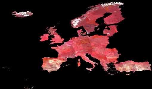
Data - Fast Registration with approval (Restrained)
Image 2007 European coverage
The Image 2007 collection is composed by products acquired by Disaster Monitoring Constellation 1st generation (DMC-1) satellites over European countries (plus Turkey) in 2007. The data provided in this collection are 32m multispectral images captured by the DMC SLIM-6 imager sensor, with two processing levels: L1R Band registered product derived from the L0R product L1T Orthorectified product derived from the L1R product using manually collected GCPs from Landsat ETM+ data and SRTM DEM V31 data Data disseminated come from the following satellites belonging to DMC-1 constellation: UK-DMC-1 Bejing-1 NigeriaSat-1 Spatial coverage: Check the spatial coverage of the collection on a map available on the Third Party Missions Dissemination Service.
Mission - Heritage Missions
DMC First Generation
The Disaster Monitoring Constellation (DMC) is a constellation of microsatellites formerly coordinated by DMCii to provide frequent observations of the Earth for monitoring natural disasters.