- All Categories (26)
- Data (4)
- News (16)
- Events (3)
- Activities (1)
- Campaigns (2)
News - General News

ESA's improved Earth system data records: what is in store for the future?
Fundamental Data Records (FDRs) are instrumental in advancing our understanding of Earth systems and for addressing societal challenges effectively. These long-term records contain uncertainty-quantified, calibrated and geo-located multi-instrument/multi-platform satellite sensor data spanning several decades to support climate-related applications.
News - Infographics
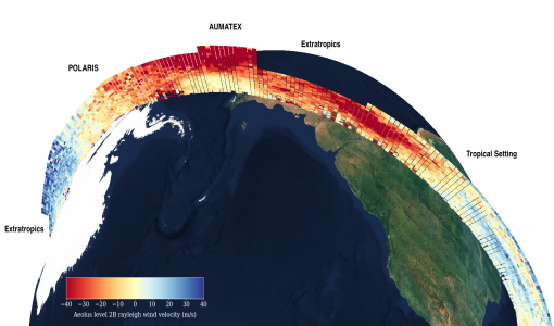
Overview of Aeolus Level-2b scientific wind data
Learn more about the Aeolus Level-2b scientific wind product in our latest infographic.
News - Success Stories
Young scientists bid farewell to ESA's wind mission
Students and early career researchers are saying an emotional goodbye to Aeolus ahead of its upcoming reentry.
News - Infographics
Overview of the Aeolus Level-1B wind product
Learn about the Aeolus Level-1B wind product, which supports applications for the weather, atmospheric processes and climate research, in our latest infographic.
News - Operational News
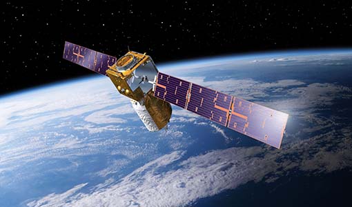
The divine keeper of the winds retires
ESA’s fifth Earth Explorer - Aeolus - is due to retire soon, but will provide fully nominal data up to the end of operations on 30 April.
News - Operational News
New Aeolus Processing Baseline 16 now activated
The new Aeolus processing baseline 16 was activated on Tuesday 18 April 2023.
News - Spotlight on EO community

An overview of the Aeolus mission
In this overview video, ESA's mission manager, Tommaso Parrinello, describes the successes and challenges of this amazing mission, whose impacts will live long beyond its lifetime in space.
News - Spotlight on EO community
Introducing the Aeolus and CryoSat missions
In this video, Tommaso Parrinello - Mission Manager of Aeolus and CryoSat - describes what is involved in managing the missions and the unique challenges offered by such innovative satellites.
News - Data Release news
Aeolus Level-2A old Baseline-11 data now publicly available
We are pleased to inform Aeolus users that 3232 Level 2A products in Baseline 11 that were not previously released are now available for browsing and download on the Aeolus Dissemination server.
News - Data Release news

Improved Aeolus wind data now available
ESA’s Aeolus mission continues to advance weather forecasting with further data improvements, thanks to a third reprocessing campaign.
News - Infographics
The JATAC campaign - Supporting ESA's Aeolus mission
A new infographic has been released for the Joint Aeolus Tropical Atlantic Campaign (JATAC).
News - Infographics
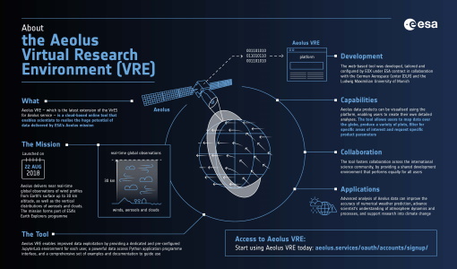
What is Aeolus VRE?
Learn more about the the Aeolus Virtual Research Environment (VRE), the latest extension to the VirES for Aeolus service, in this infographic.
News - Success Stories
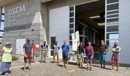
Askos campaign validates Aeolus data
From July to September 2021, the European Space Agency (ESA) organised the Joint Aeolus Tropical Atlantic Campaign (JATAC) in Cape Verde.
Data - EO Sign In Authentication (Open)
Aeolus L2A Aerosol/Cloud optical product
The Level 2A aerosol/cloud optical products of the Aeolus mission include: Geo-located consolidated backscatter and extinction profiles Backscatter-to-extinction coefficient LIDAR ratio, scene classification Heterogeneity index Attenuated backscatter signals. Resolution: Horizontal resolution of L2A optical properties at observation scale (~87 km); Exceptions are group properties (horizontal accumulation of measurements from ~3 km to ~87 km) and attenuated backscatters (~3 km). Note: The resolution of "groups" in the L2A can only go down to 5 measurements at the moment, i.e. ~15 km horizontal resolution. This could be configured to go to 1 measurement - Vertical resolution 250-2000 m (Defined by Range Bin Settings).
News - Operational News
A Guide to Aeolus Range Bin Settings
After almost two years in space, Aeolus' near-real time observations have been assimilated into the Numerical Weather Prediction models of several European meteorological services, and have proven crucial during the COVID-19 pandemic, which led to a sharp decrease in meteorological observations.
News - Operational News
Aeolus set for Instrument Telescope Refocussing exercise
Aeolus's telescope requires periodic collimation and refocussing. To this end, the Instrument Telescope Refocussing activity aims to improve the radiometric performance of the Atmospheric Laser Doppler Instrument's telescope, ALADIN.
News - Success Stories
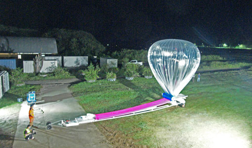
Around the world in eight balloons with Strateole-2
Strateole-2 is a French-US project supported by ESA that uses CNES superpressure balloons drifting around the globe to study the climate processes in the Tropical Tropopause Layer (TTL) and the lower stratosphere, helping Aeolus validation activities along the way.
Activity - Quality
Aeolus DISC
The Aeolus DISC is the core element in ESA's data quality framework for the Aeolus mission, comprised of an international expert consortium to study and improve the data quality of Aeolus products.
Data - Fast Registration with approval (Restrained)
ERS-1/2 ATSR Averaged Surface Temperature [AT1/AT2_AR__2P]
The Averaged Surface Temperature Product (AST) contains averaged geophysical data at two different resolutions, and with respect to two different averaging schemes: measurement data sets at resolutions of 0.5 by 0.5 degrees and 10 by 10 arcmin with respect to a latitude/longitude grid; other data sets contain data averaged over equal area cells of 50 by 50 km and 17 by 17 km aligned with the satellite ground track. Both top-of-atmosphere and surface data sets are provided. The surface temperature data sets provide, for sea cells, nadir and dual view sea surface temperatures, and for land cells, land surface temperature (currently 11 micron BT) and NDVI. Cloud data is also included. No ADS are included in the AST product; auxiliary data is contained within the MDS. The data sets of the AST product are arranged by surface type and resolution. The 3rd reprocessing of ATSR data was performed in 2013; the processing updates that have been put in place and the scientific improvements are outlined in full in the User Summary Note for the Third ERS ATSR Reprocessing.
Data - Fast Registration with approval (Restrained)
ERS-1/2 ATSR Gridded Brightness Temperature/Reflectance [AT1/AT2_TOA_1P]
The Gridded Brightness Temperature/Reflectance (GBTR) product contains top of atmosphere (TOA) brightness temperature (BT) values for the infra-red channels and reflectance values for the visible channels. Values for each channel and for the nadir and forward views occupy separate measurement data sets. Additional MDS contain cloud and land/sea flags and confidence flags for each image pixel. The 3rd reprocessing of ATSR data was performed in 2013; the processing updates that have been put in place and the scientific improvements are outlined in full in the User Summary Note for the Third ERS ATSR Reprocessing.